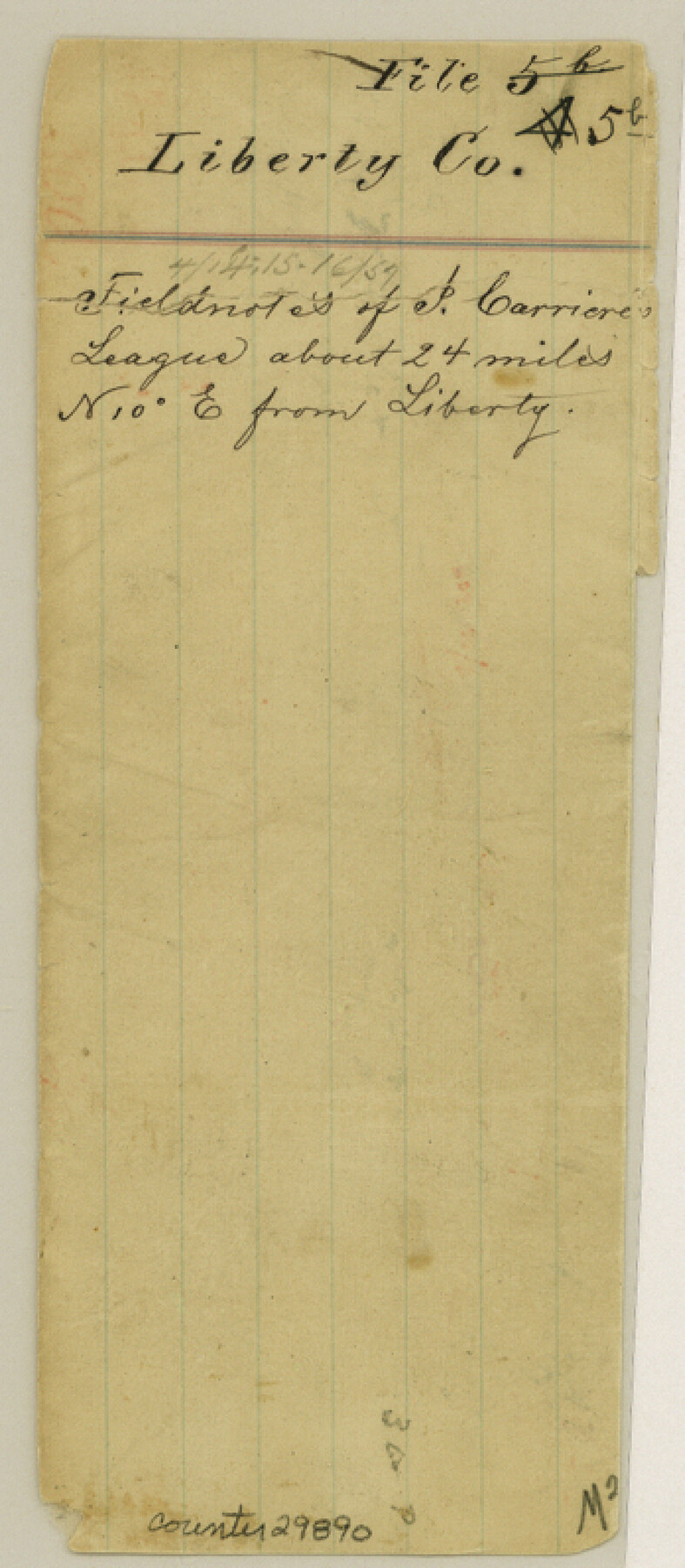
Liberty County Sketch File 5b
[Field notes and sketch of a league of land titled to Joseph Carriere in the north part of the county on the Liberty-Hardin County line]
-
Map/Doc
29890
-
Collection
General Map Collection
-
Object Dates
4/18/1857 (Creation Date)
4/16/1857 (Survey Date)
-
People and Organizations
A.B. Worsham (Chainman/Field Personnel)
Carson Obar (Chainman/Field Personnel)
John Brinkley (Chainman/Field Personnel)
A.N.B. Tompkins (Surveyor/Engineer)
-
Counties
Liberty Hardin
-
Subjects
Surveying Sketch File
-
Height x Width
8.0 x 3.5 inches
20.3 x 8.9 cm
-
Medium
paper, manuscript
-
Features
Pine Island Bayou
Menard's Creek
Part of: General Map Collection
Pecos County Rolled Sketch 185

Print $20.00
- Digital $50.00
Pecos County Rolled Sketch 185
1985
Size 34.9 x 29.0 inches
Map/Doc 7304
Right of Way and Track Map, Galveston, Harrisburg & San Antonio Ry. operated by the T. & N. O. R.R. Co., Victoria Division, Rosenberg to Beeville

Print $40.00
- Digital $50.00
Right of Way and Track Map, Galveston, Harrisburg & San Antonio Ry. operated by the T. & N. O. R.R. Co., Victoria Division, Rosenberg to Beeville
1918
Size 24.8 x 57.1 inches
Map/Doc 76159
Montgomery County Rolled Sketch 27

Print $20.00
- Digital $50.00
Montgomery County Rolled Sketch 27
Size 34.5 x 34.4 inches
Map/Doc 9536
Pecos County Sketch File 1A

Print $20.00
- Digital $50.00
Pecos County Sketch File 1A
1919
Size 34.3 x 23.7 inches
Map/Doc 12155
Stephens County Working Sketch 36

Print $20.00
- Digital $50.00
Stephens County Working Sketch 36
1980
Size 35.5 x 32.3 inches
Map/Doc 63979
San Augustine County Working Sketch 5

Print $20.00
- Digital $50.00
San Augustine County Working Sketch 5
1935
Size 39.0 x 37.4 inches
Map/Doc 63692

Reeves County Rolled Sketch N

Print $40.00
- Digital $50.00
Reeves County Rolled Sketch N
Size 44.5 x 74.7 inches
Map/Doc 9846
Val Verde County Working Sketch 112

Print $40.00
- Digital $50.00
Val Verde County Working Sketch 112
1990
Size 48.2 x 30.8 inches
Map/Doc 72247
Presidio County Rolled Sketch 146

Print $20.00
- Digital $50.00
Presidio County Rolled Sketch 146
2018
Size 29.8 x 41.8 inches
Map/Doc 95821
Anderson County Working Sketch 11a

Print $40.00
- Digital $50.00
Anderson County Working Sketch 11a
1933
Size 42.7 x 64.2 inches
Map/Doc 67011
San Patricio County NRC Article 33.136 Location Key Sheet

Print $20.00
- Digital $50.00
San Patricio County NRC Article 33.136 Location Key Sheet
1975
Size 27.0 x 23.0 inches
Map/Doc 77035
You may also like
Leon County Rolled Sketch 34

Print $20.00
- Digital $50.00
Leon County Rolled Sketch 34
1999
Size 31.8 x 37.1 inches
Map/Doc 87502
Duval County Sketch File 40a

Print $10.00
- Digital $50.00
Duval County Sketch File 40a
Size 13.9 x 8.8 inches
Map/Doc 21389
Brown County Sketch File 10

Print $40.00
- Digital $50.00
Brown County Sketch File 10
1868
Size 17.4 x 22.3 inches
Map/Doc 11019
Foard County Aerial Photograph Index Sheet 2

Print $20.00
- Digital $50.00
Foard County Aerial Photograph Index Sheet 2
1950
Size 22.1 x 18.8 inches
Map/Doc 83689
Flight Mission No. CGI-4N, Frame 185, Cameron County

Print $20.00
- Digital $50.00
Flight Mission No. CGI-4N, Frame 185, Cameron County
1955
Size 18.6 x 22.3 inches
Map/Doc 84688
Hutchinson County Rolled Sketch 2

Print $20.00
- Digital $50.00
Hutchinson County Rolled Sketch 2
Size 36.1 x 42.0 inches
Map/Doc 76069

Map Showing the Route of the Arkansas Regiment from Shreveport La. To San Antonio de Bexar Texas

Print $20.00
- Digital $50.00
Map Showing the Route of the Arkansas Regiment from Shreveport La. To San Antonio de Bexar Texas
Size 12.5 x 19.5 inches
Map/Doc 94000
Flight Mission No. BRA-16M, Frame 87, Jefferson County

Print $20.00
- Digital $50.00
Flight Mission No. BRA-16M, Frame 87, Jefferson County
1953
Size 18.6 x 22.3 inches
Map/Doc 85699
General Highway Map, Freestone County, Texas

Print $20.00
General Highway Map, Freestone County, Texas
1940
Size 18.6 x 25.1 inches
Map/Doc 79094
[Area around Lee County School Land Leagues]
![90804, [Area around Lee County School Land Leagues], Twichell Survey Records](https://historictexasmaps.com/wmedia_w700/maps/90804-1.tif.jpg)
Print $3.00
- Digital $50.00
[Area around Lee County School Land Leagues]
Size 9.7 x 15.2 inches
Map/Doc 90804
PSL Field Notes for Blocks 1 and 2, Hansford and Sherman Counties, Blocks 3 and 4, Hansford County, Blocks A1, A2, A4, A5, and A6 in Hartley County, Block C0 in Hockley, Lubbock, Lynn, and Terry Counties, and Blocks A and B in Kent County

PSL Field Notes for Blocks 1 and 2, Hansford and Sherman Counties, Blocks 3 and 4, Hansford County, Blocks A1, A2, A4, A5, and A6 in Hartley County, Block C0 in Hockley, Lubbock, Lynn, and Terry Counties, and Blocks A and B in Kent County
Map/Doc 81655