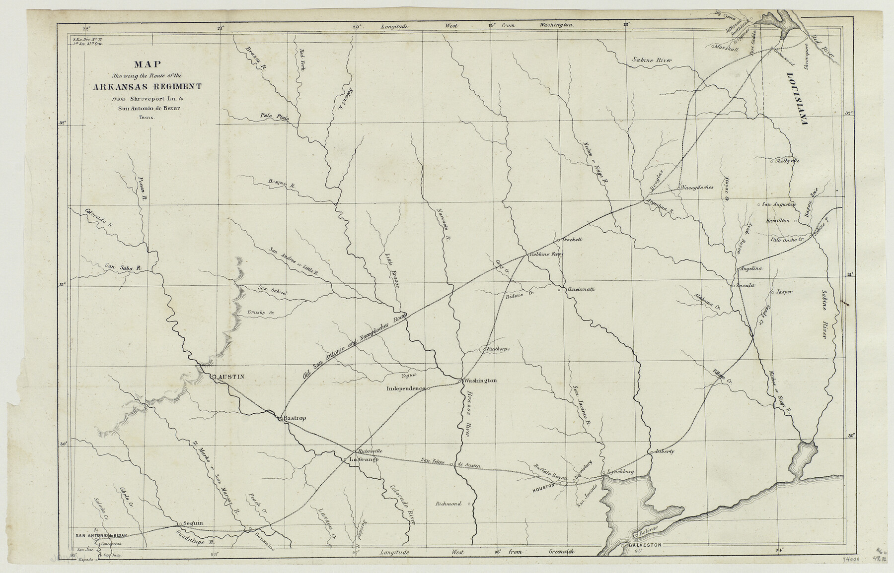
Map Showing the Route of the Arkansas Regiment from Shreveport La. To San Antonio de Bexar Texas
-
Map/Doc
94000
-
Collection
General Map Collection
-
Object Dates
1850 (Publication Date)
-
Subjects
Military
-
Height x Width
12.5 x 19.5 inches
31.8 x 49.5 cm
-
Medium
paper, etching/engraving/lithograph
-
Comments
Map published in S. Ex. Doc No. 32, 1st Session, 31st Congress.
Part of: General Map Collection
El Paso County Sketch File 36

Print $2.00
- Digital $50.00
El Paso County Sketch File 36
1984
Size 11.6 x 9.0 inches
Map/Doc 24123
Webb County Sketch File 6-1

Print $6.00
- Digital $50.00
Webb County Sketch File 6-1
1877
Size 9.8 x 12.7 inches
Map/Doc 39737
Webb County Working Sketch 76

Print $20.00
- Digital $50.00
Webb County Working Sketch 76
1975
Size 43.3 x 37.5 inches
Map/Doc 72443
Current Miscellaneous File 49

Print $4.00
- Digital $50.00
Current Miscellaneous File 49
Size 11.2 x 8.8 inches
Map/Doc 74012
Red River County Rolled Sketch 8

Print $20.00
- Digital $50.00
Red River County Rolled Sketch 8
Size 32.5 x 17.3 inches
Map/Doc 7474

Dimmit County Working Sketch 50

Print $20.00
- Digital $50.00
Dimmit County Working Sketch 50
1981
Size 34.0 x 39.0 inches
Map/Doc 68711
Hudspeth County Working Sketch 34

Print $40.00
- Digital $50.00
Hudspeth County Working Sketch 34
1977
Size 63.1 x 37.3 inches
Map/Doc 66319
Edwards County Working Sketch 114

Print $20.00
- Digital $50.00
Edwards County Working Sketch 114
1972
Size 33.6 x 33.1 inches
Map/Doc 68990
Canada, United States of America, Estados Unidos Mexicanos

Print $20.00
- Digital $50.00
Canada, United States of America, Estados Unidos Mexicanos
Size 41.9 x 36.1 inches
Map/Doc 96512
Shackelford County Working Sketch 9

Print $20.00
- Digital $50.00
Shackelford County Working Sketch 9
1974
Size 30.1 x 22.2 inches
Map/Doc 63849
Stephens County Sketch File 15

Print $4.00
- Digital $50.00
Stephens County Sketch File 15
1890
Size 9.1 x 6.7 inches
Map/Doc 37068
You may also like
Atascosa County Rolled Sketch 10

Print $40.00
- Digital $50.00
Atascosa County Rolled Sketch 10
1943
Size 36.0 x 77.6 inches
Map/Doc 8428
Montague County Working Sketch 22

Print $20.00
- Digital $50.00
Montague County Working Sketch 22
1952
Size 29.5 x 24.6 inches
Map/Doc 71088
Chambers County Rolled Sketch 11

Print $20.00
- Digital $50.00
Chambers County Rolled Sketch 11
Size 20.0 x 26.5 inches
Map/Doc 5424
Robertson County Rolled Sketch 5

Print $20.00
- Digital $50.00
Robertson County Rolled Sketch 5
1976
Size 34.1 x 36.4 inches
Map/Doc 9864
Crockett County Rolled Sketch 66

Print $20.00
- Digital $50.00
Crockett County Rolled Sketch 66
1947
Size 22.4 x 23.3 inches
Map/Doc 5609
Van Zandt County Sketch File 14

Print $4.00
- Digital $50.00
Van Zandt County Sketch File 14
1858
Size 7.9 x 8.1 inches
Map/Doc 39404
Flight Mission No. CGI-3N, Frame 51, Cameron County

Print $20.00
- Digital $50.00
Flight Mission No. CGI-3N, Frame 51, Cameron County
1954
Size 18.6 x 22.2 inches
Map/Doc 84557
Bee County Working Sketch 7

Print $20.00
- Digital $50.00
Bee County Working Sketch 7
1939
Size 17.8 x 20.6 inches
Map/Doc 67257
Donley County Sketch File 28

Print $40.00
- Digital $50.00
Donley County Sketch File 28
Size 25.7 x 9.1 inches
Map/Doc 21266
Travis County Sketch File XYZ

Print $4.00
- Digital $50.00
Travis County Sketch File XYZ
Size 10.1 x 8.3 inches
Map/Doc 38352
Gaines County, Texas

Print $40.00
- Digital $50.00
Gaines County, Texas
1915
Size 54.1 x 33.0 inches
Map/Doc 89843
General Highway Map, Dawson County, Texas

Print $20.00
General Highway Map, Dawson County, Texas
1961
Size 18.0 x 24.5 inches
Map/Doc 79436