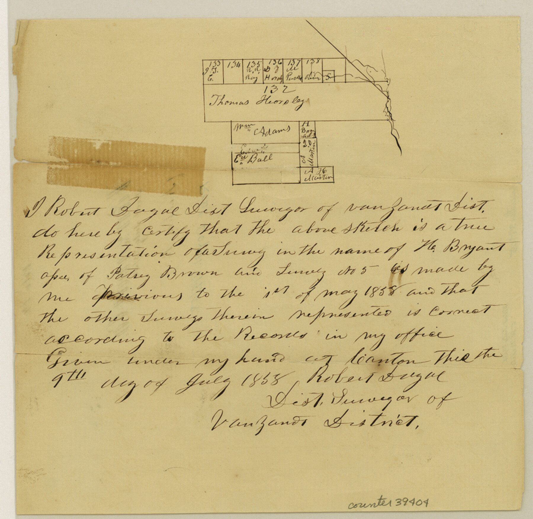
Van Zandt County Sketch File 14
[Sketch of surveys on the west side of the Neches River in the southeast part of the county]
-
Map/Doc
39404
-
Collection
General Map Collection
-
Object Dates
7/9/1858 (Creation Date)
7/23/1858 (File Date)
-
People and Organizations
Robert Doyal (Surveyor/Engineer)
-
Counties
Van Zandt
-
Subjects
Surveying Sketch File
-
Height x Width
7.9 x 8.1 inches
20.1 x 20.6 cm
-
Medium
paper, manuscript
-
Features
Neches River
Part of: General Map Collection
Flight Mission No. DCL-7C, Frame 142, Kenedy County

Print $20.00
- Digital $50.00
Flight Mission No. DCL-7C, Frame 142, Kenedy County
1943
Size 18.6 x 22.5 inches
Map/Doc 86099
Current Miscellaneous File 118

Print $214.00
- Digital $50.00
Current Miscellaneous File 118
Map/Doc 87238
Edwards County Sketch File A

Print $20.00
- Digital $50.00
Edwards County Sketch File A
Size 25.3 x 35.5 inches
Map/Doc 11448
Schleicher County Sketch File 22

Print $9.00
- Digital $50.00
Schleicher County Sketch File 22
1927
Size 12.8 x 11.7 inches
Map/Doc 36512
Val Verde County Sketch File 49

Print $20.00
- Digital $50.00
Val Verde County Sketch File 49
1953
Size 27.1 x 20.2 inches
Map/Doc 12590
Dickens County Rolled Sketch 7

Print $20.00
- Digital $50.00
Dickens County Rolled Sketch 7
1947
Size 33.6 x 23.6 inches
Map/Doc 5706
Map of certain tidal areas in Harris and Galveston Counties showing subdivision thereof for mineral development

Print $20.00
- Digital $50.00
Map of certain tidal areas in Harris and Galveston Counties showing subdivision thereof for mineral development
1938
Size 34.3 x 26.7 inches
Map/Doc 2936
Bee County Sketch File 14

Print $40.00
- Digital $50.00
Bee County Sketch File 14
1878
Size 14.5 x 12.5 inches
Map/Doc 14297
Brewster County Rolled Sketch 60

Print $20.00
- Digital $50.00
Brewster County Rolled Sketch 60
Size 25.0 x 37.5 inches
Map/Doc 8484
Flight Mission No. DIX-6P, Frame 118, Aransas County

Print $20.00
- Digital $50.00
Flight Mission No. DIX-6P, Frame 118, Aransas County
1956
Size 19.1 x 22.9 inches
Map/Doc 83824
Intracoastal Waterway - Laguna Madre - Chubby Island to Stover Point including the Arroyo Colorado, Texas

Print $20.00
- Digital $50.00
Intracoastal Waterway - Laguna Madre - Chubby Island to Stover Point including the Arroyo Colorado, Texas
1976
Size 15.6 x 43.8 inches
Map/Doc 75900
Andrews County

Print $40.00
- Digital $50.00
Andrews County
1901
Size 35.9 x 49.7 inches
Map/Doc 4872
You may also like
Presidio County Working Sketch 101

Print $20.00
- Digital $50.00
Presidio County Working Sketch 101
1979
Size 37.6 x 31.0 inches
Map/Doc 71778
Polk County Sketch File 24

Print $20.00
- Digital $50.00
Polk County Sketch File 24
Size 14.3 x 30.8 inches
Map/Doc 12193
Map of Gonzales County

Print $40.00
- Digital $50.00
Map of Gonzales County
1842
Size 59.5 x 50.0 inches
Map/Doc 16839
[Surveys in the Liberty District in Tyler and Polk Counties]
![331, [Surveys in the Liberty District in Tyler and Polk Counties], General Map Collection](https://historictexasmaps.com/wmedia_w700/maps/331.tif.jpg)
Print $2.00
- Digital $50.00
[Surveys in the Liberty District in Tyler and Polk Counties]
1847
Size 5.9 x 8.4 inches
Map/Doc 331
[Galveston, Harrisburg & San Antonio through El Paso County]
![64012, [Galveston, Harrisburg & San Antonio through El Paso County], General Map Collection](https://historictexasmaps.com/wmedia_w700/maps/64012.tif.jpg)
Print $20.00
- Digital $50.00
[Galveston, Harrisburg & San Antonio through El Paso County]
1906
Size 13.6 x 33.8 inches
Map/Doc 64012
Wheeler County

Print $20.00
- Digital $50.00
Wheeler County
1899
Size 44.2 x 38.7 inches
Map/Doc 63121
Kinney County Sketch File 36

Print $20.00
- Digital $50.00
Kinney County Sketch File 36
1946
Size 19.2 x 22.0 inches
Map/Doc 11949
Reeves County Working Sketch 52
Print $40.00
- Digital $50.00
Reeves County Working Sketch 52
1977
Size 60.3 x 41.9 inches
Map/Doc 63495
Eastland County Working Sketch 5

Print $20.00
- Digital $50.00
Eastland County Working Sketch 5
1918
Size 16.1 x 19.3 inches
Map/Doc 68786
Freestone County Working Sketch 23

Print $20.00
- Digital $50.00
Freestone County Working Sketch 23
1982
Size 20.1 x 17.0 inches
Map/Doc 69265
Kendall County Sketch File 23

Print $40.00
- Digital $50.00
Kendall County Sketch File 23
1938
Size 15.5 x 15.9 inches
Map/Doc 28716
Current Miscellaneous File 120

Print $14.00
- Digital $50.00
Current Miscellaneous File 120
Size 8.5 x 11.0 inches
Map/Doc 88754