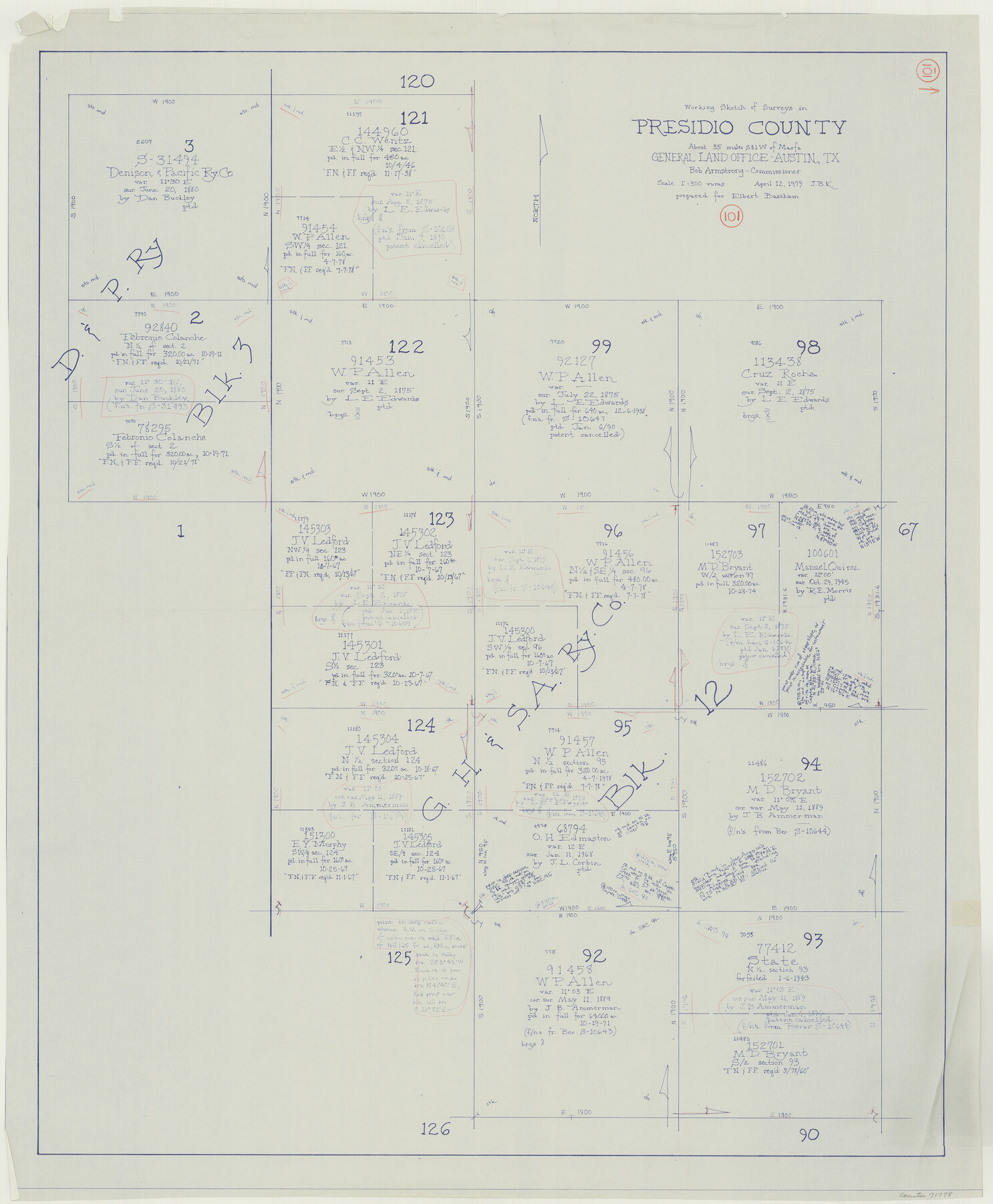
Presidio County Working Sketch 101
-
Map/Doc
71778
-
Collection
General Map Collection
-
Object Dates
4/12/1979 (Creation Date)
-
People and Organizations
Joan Kilpatrick (Draftsman)
-
Counties
Presidio
-
Subjects
Surveying Working Sketch
-
Height x Width
37.6 x 31.0 inches
95.5 x 78.7 cm
-
Scale
1" = 300 varas
Part of: General Map Collection
[Texas & Pacific Railway through Callahan County]
![64232, [Texas & Pacific Railway through Callahan County], General Map Collection](https://historictexasmaps.com/wmedia_w700/maps/64232.tif.jpg)
Print $20.00
- Digital $50.00
[Texas & Pacific Railway through Callahan County]
1918
Size 20.8 x 9.4 inches
Map/Doc 64232
Duval County Sketch File 65

Print $6.00
- Digital $50.00
Duval County Sketch File 65
1943
Size 14.4 x 9.1 inches
Map/Doc 21441
Packery Channel

Print $20.00
- Digital $50.00
Packery Channel
1950
Size 17.6 x 17.5 inches
Map/Doc 2997
Reeves County Rolled Sketch 40

Print $20.00
- Digital $50.00
Reeves County Rolled Sketch 40
2019
Size 18.1 x 24.2 inches
Map/Doc 95826
San Patricio County Rolled Sketch 46D

Print $20.00
- Digital $50.00
San Patricio County Rolled Sketch 46D
1983
Size 14.8 x 36.0 inches
Map/Doc 8375
Maps of Gulf Intracoastal Waterway, Texas - Sabine River to the Rio Grande and connecting waterways including ship channels

Print $20.00
- Digital $50.00
Maps of Gulf Intracoastal Waterway, Texas - Sabine River to the Rio Grande and connecting waterways including ship channels
1966
Size 14.6 x 21.6 inches
Map/Doc 61982
Potter County Sketch File 6A

Print $20.00
- Digital $50.00
Potter County Sketch File 6A
Size 16.7 x 17.3 inches
Map/Doc 12196
Stonewall County Working Sketch 4

Print $20.00
- Digital $50.00
Stonewall County Working Sketch 4
1919
Size 28.7 x 23.8 inches
Map/Doc 63998
Flight Mission No. CGI-3N, Frame 126, Cameron County

Print $20.00
- Digital $50.00
Flight Mission No. CGI-3N, Frame 126, Cameron County
1954
Size 18.5 x 22.1 inches
Map/Doc 84599
Foard County Sketch File XX

Print $40.00
- Digital $50.00
Foard County Sketch File XX
1884
Size 14.0 x 16.4 inches
Map/Doc 22802
The University of Texas at Austin

The University of Texas at Austin
Size 16.0 x 17.1 inches
Map/Doc 94388
Montgomery County Sketch File 2a

Print $4.00
- Digital $50.00
Montgomery County Sketch File 2a
1849
Size 8.0 x 12.3 inches
Map/Doc 31768
You may also like
Polk County Sketch File 22

Print $6.00
- Digital $50.00
Polk County Sketch File 22
1887
Size 8.9 x 7.5 inches
Map/Doc 34173
Pecos County Rolled Sketch 32

Print $20.00
- Digital $50.00
Pecos County Rolled Sketch 32
1890
Size 21.0 x 14.1 inches
Map/Doc 7214
Presidio County Working Sketch 72

Print $20.00
- Digital $50.00
Presidio County Working Sketch 72
1962
Size 22.1 x 21.1 inches
Map/Doc 71749
Travis County Sketch File 62

Print $20.00
- Digital $50.00
Travis County Sketch File 62
1929
Size 20.6 x 18.2 inches
Map/Doc 12473
Reagan County Boundary File 1d

Print $36.00
- Digital $50.00
Reagan County Boundary File 1d
Size 9.2 x 8.3 inches
Map/Doc 58181
Montgomery County Working Sketch 18

Print $20.00
- Digital $50.00
Montgomery County Working Sketch 18
1935
Size 34.0 x 39.1 inches
Map/Doc 71125
Flight Mission No. CUG-3P, Frame 13, Kleberg County

Print $20.00
- Digital $50.00
Flight Mission No. CUG-3P, Frame 13, Kleberg County
1956
Size 18.6 x 22.1 inches
Map/Doc 86223
Brazoria County Sketch File 26

Print $40.00
- Digital $50.00
Brazoria County Sketch File 26
Size 13.6 x 13.6 inches
Map/Doc 15028
Real County Working Sketch 76

Print $20.00
- Digital $50.00
Real County Working Sketch 76
1979
Size 30.6 x 21.1 inches
Map/Doc 71968
Jones County Sketch File 8

Print $20.00
- Digital $50.00
Jones County Sketch File 8
Size 18.5 x 22.8 inches
Map/Doc 11898
Nueces County Rolled Sketch 34

Print $20.00
- Digital $50.00
Nueces County Rolled Sketch 34
1951
Size 47.9 x 37.5 inches
Map/Doc 9601
Sketch in Cochran County, Texas

Print $20.00
- Digital $50.00
Sketch in Cochran County, Texas
1940
Size 33.1 x 26.5 inches
Map/Doc 92489