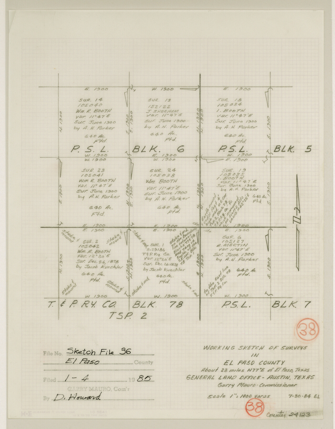
El Paso County Sketch File 36
Working Sketch of surveys in El Paso County
-
Map/Doc
24123
-
Collection
General Map Collection
-
Object Dates
1984/7/30 (Creation Date)
1985/1/4 (File Date)
1900 (Survey Date)
1878/12/26 (Survey Date)
-
People and Organizations
E.L. (Draftsman)
-
Counties
El Paso
-
Subjects
Surveying Sketch File
-
Height x Width
11.6 x 9.0 inches
29.5 x 22.9 cm
-
Medium
paper, manuscript
-
Scale
1" = 1000 varas
Part of: General Map Collection
Comal County State Real Property Sketch 1

Print $134.00
- Digital $50.00
Comal County State Real Property Sketch 1
2006
Size 23.8 x 35.4 inches
Map/Doc 88635
Located Line of the Panhandle & Gulf Ry. through State Lands

Print $40.00
- Digital $50.00
Located Line of the Panhandle & Gulf Ry. through State Lands
1904
Size 12.4 x 78.0 inches
Map/Doc 64104
McLennan County Sketch File 31

Print $22.00
- Digital $50.00
McLennan County Sketch File 31
Size 14.2 x 17.2 inches
Map/Doc 31306
Map of Located Land of Gulf, Colorado & Santa Fe Ry. Co. through Denton

Print $40.00
- Digital $50.00
Map of Located Land of Gulf, Colorado & Santa Fe Ry. Co. through Denton
Size 55.5 x 25.8 inches
Map/Doc 64341
La Salle County Sketch File 30

Print $22.00
- Digital $50.00
La Salle County Sketch File 30
1880
Size 12.6 x 8.2 inches
Map/Doc 29565
Austin Street Map & Guide

Digital $50.00
Austin Street Map & Guide
Size 35.3 x 23.2 inches
Map/Doc 94434
Real County Sketch File 10

Print $6.00
- Digital $50.00
Real County Sketch File 10
1932
Size 10.3 x 15.0 inches
Map/Doc 35063
[Beaumont, Sour Lake and Western Ry. Right of Way and Alignment - Frisco]
![64123, [Beaumont, Sour Lake and Western Ry. Right of Way and Alignment - Frisco], General Map Collection](https://historictexasmaps.com/wmedia_w700/maps/64123.tif.jpg)
Print $20.00
- Digital $50.00
[Beaumont, Sour Lake and Western Ry. Right of Way and Alignment - Frisco]
1910
Size 20.4 x 46.2 inches
Map/Doc 64123
Flight Mission No. DCL-7C, Frame 14, Kenedy County

Print $20.00
- Digital $50.00
Flight Mission No. DCL-7C, Frame 14, Kenedy County
1943
Size 15.3 x 15.2 inches
Map/Doc 86006
Flight Mission No. DQN-1K, Frame 139, Calhoun County

Print $20.00
- Digital $50.00
Flight Mission No. DQN-1K, Frame 139, Calhoun County
1953
Size 18.4 x 22.3 inches
Map/Doc 84202
Edwards County Rolled Sketch O

Print $20.00
- Digital $50.00
Edwards County Rolled Sketch O
Size 13.6 x 18.3 inches
Map/Doc 5820
Reeves County Working Sketch 2

Print $20.00
- Digital $50.00
Reeves County Working Sketch 2
1903
Size 22.6 x 42.4 inches
Map/Doc 63444
You may also like
Flight Mission No. DQO-7K, Frame 113, Galveston County

Print $20.00
- Digital $50.00
Flight Mission No. DQO-7K, Frame 113, Galveston County
1952
Size 18.7 x 22.3 inches
Map/Doc 85128
Maverick County Sketch File 17

Print $20.00
- Digital $50.00
Maverick County Sketch File 17
Size 15.4 x 18.2 inches
Map/Doc 12052
Concho County Sketch File 8 1/4

Print $20.00
- Digital $50.00
Concho County Sketch File 8 1/4
Size 23.4 x 15.0 inches
Map/Doc 11149
Yellow Fever Deaths in the United States

Yellow Fever Deaths in the United States
2022
Size 8.5 x 11.0 inches
Map/Doc 97093
Webb County Sketch File 25

Print $20.00
- Digital $50.00
Webb County Sketch File 25
1936
Size 18.2 x 30.7 inches
Map/Doc 12639
Jeff Davis County Sketch File 34

Print $16.00
- Digital $50.00
Jeff Davis County Sketch File 34
1915
Size 8.5 x 5.4 inches
Map/Doc 28040
[Surveys in the Bexar District along the Sabinal River and Rancheros Creek]
![95, [Surveys in the Bexar District along the Sabinal River and Rancheros Creek], General Map Collection](https://historictexasmaps.com/wmedia_w700/maps/95.tif.jpg)
Print $2.00
- Digital $50.00
[Surveys in the Bexar District along the Sabinal River and Rancheros Creek]
1846
Size 8.6 x 7.8 inches
Map/Doc 95
Flight Mission No. DQO-8K, Frame 132, Galveston County

Print $20.00
- Digital $50.00
Flight Mission No. DQO-8K, Frame 132, Galveston County
1952
Size 18.8 x 22.6 inches
Map/Doc 85197
Pecos County Sketch File 23

Print $20.00
- Digital $50.00
Pecos County Sketch File 23
1886
Size 18.0 x 18.0 inches
Map/Doc 12162
Flight Mission No. DQO-2K, Frame 163, Galveston County

Print $20.00
- Digital $50.00
Flight Mission No. DQO-2K, Frame 163, Galveston County
1952
Size 18.8 x 22.5 inches
Map/Doc 85052
Correct Map of the Railway and Steamship Lines operated by the Southern Pacific Company

Print $20.00
Correct Map of the Railway and Steamship Lines operated by the Southern Pacific Company
1894
Size 17.0 x 40.1 inches
Map/Doc 79333
Presidio County Working Sketch 102

Print $20.00
- Digital $50.00
Presidio County Working Sketch 102
1980
Size 30.9 x 28.9 inches
Map/Doc 71779