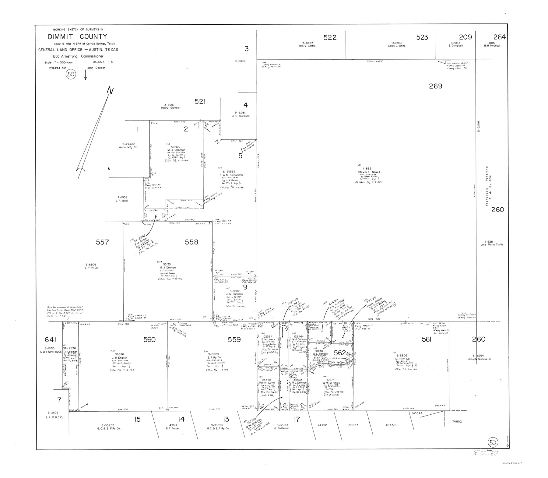
Dimmit County Working Sketch 50
-
Map/Doc
68711
-
Collection
General Map Collection
-
Object Dates
10/26/1981 (Creation Date)
-
People and Organizations
Jana Brod (Draftsman)
-
Counties
Dimmit
-
Subjects
Surveying Working Sketch
-
Height x Width
34.0 x 39.0 inches
86.4 x 99.1 cm
-
Scale
1" = 300 varas
Part of: General Map Collection
Flight Mission No. DCL-3C, Frame 105, Kenedy County

Print $20.00
- Digital $50.00
Flight Mission No. DCL-3C, Frame 105, Kenedy County
1943
Size 18.6 x 22.2 inches
Map/Doc 85800
Jack County Working Sketch 3

Print $20.00
- Digital $50.00
Jack County Working Sketch 3
1940
Size 18.8 x 26.0 inches
Map/Doc 66429
Menard County Working Sketch 33

Print $20.00
- Digital $50.00
Menard County Working Sketch 33
1989
Size 27.2 x 25.2 inches
Map/Doc 70980
Ward County Working Sketch 30

Print $40.00
- Digital $50.00
Ward County Working Sketch 30
1964
Size 118.5 x 43.4 inches
Map/Doc 72336
Edwards County Sketch File 7

Print $26.00
- Digital $50.00
Edwards County Sketch File 7
1880
Size 8.0 x 7.9 inches
Map/Doc 21684
[Surveys in Austin's Colony along the east bank of Mill Creek]
![216, [Surveys in Austin's Colony along the east bank of Mill Creek], General Map Collection](https://historictexasmaps.com/wmedia_w700/maps/216.tif.jpg)
Print $3.00
- Digital $50.00
[Surveys in Austin's Colony along the east bank of Mill Creek]
1827
Size 14.4 x 11.1 inches
Map/Doc 216
Stonewall County Sketch File 26

Print $20.00
- Digital $50.00
Stonewall County Sketch File 26
1953
Size 35.7 x 36.8 inches
Map/Doc 10376
Baylor County Sketch File 19

Print $4.00
- Digital $50.00
Baylor County Sketch File 19
1885
Size 11.5 x 8.8 inches
Map/Doc 14193
Nolan County Working Sketch 2

Print $20.00
- Digital $50.00
Nolan County Working Sketch 2
1943
Size 26.7 x 25.0 inches
Map/Doc 71293
Montgomery County Sketch File 14

Print $42.00
- Digital $50.00
Montgomery County Sketch File 14
1905
Size 11.0 x 8.8 inches
Map/Doc 31805
Map of Callahan County

Print $20.00
- Digital $50.00
Map of Callahan County
1859
Size 24.5 x 19.4 inches
Map/Doc 3360
Refugio County Sketch File 8b

Print $4.00
- Digital $50.00
Refugio County Sketch File 8b
1876
Size 8.5 x 10.5 inches
Map/Doc 35254
You may also like
[Map of California and Nevada]
![96620, [Map of California and Nevada], Cobb Digital Map Collection](https://historictexasmaps.com/wmedia_w700/maps/96620.tif.jpg)
Print $20.00
- Digital $50.00
[Map of California and Nevada]
1869
Size 9.1 x 10.6 inches
Map/Doc 96620
Padre Island National Seashore, Texas - Dependent Resurvey

Print $2.00
- Digital $50.00
Padre Island National Seashore, Texas - Dependent Resurvey
Size 11.5 x 8.3 inches
Map/Doc 60542
Runnels County Working Sketch 30b

Print $20.00
- Digital $50.00
Runnels County Working Sketch 30b
Size 23.2 x 25.3 inches
Map/Doc 63627
Real County Working Sketch 2

Print $20.00
- Digital $50.00
Real County Working Sketch 2
1891
Size 19.7 x 20.6 inches
Map/Doc 71894
Midland County Working Sketch Graphic Index

Print $20.00
- Digital $50.00
Midland County Working Sketch Graphic Index
1930
Size 43.3 x 35.3 inches
Map/Doc 76641
Flight Mission No. CGI-3N, Frame 185, Cameron County

Print $20.00
- Digital $50.00
Flight Mission No. CGI-3N, Frame 185, Cameron County
1954
Size 18.6 x 22.4 inches
Map/Doc 84649
El Paso County Boundary File 7

Print $14.00
- Digital $50.00
El Paso County Boundary File 7
Size 14.0 x 8.8 inches
Map/Doc 53087
Dickens County Rolled Sketch 5A

Print $40.00
- Digital $50.00
Dickens County Rolled Sketch 5A
1947
Size 60.3 x 40.9 inches
Map/Doc 8788
Leon County Sketch File 5

Print $4.00
- Digital $50.00
Leon County Sketch File 5
Size 8.0 x 7.8 inches
Map/Doc 29715
Liberty County Sketch File B

Print $4.00
- Digital $50.00
Liberty County Sketch File B
1869
Size 12.0 x 8.2 inches
Map/Doc 30066
Nueces County Sketch File 26

Print $40.00
- Digital $50.00
Nueces County Sketch File 26
1890
Size 26.7 x 23.2 inches
Map/Doc 42184
Boundary Between the United States & Mexico Agreed upon by the Joint Commission under the Treaty of Guadalupe Hidalgo

Print $4.00
- Digital $50.00
Boundary Between the United States & Mexico Agreed upon by the Joint Commission under the Treaty of Guadalupe Hidalgo
1853
Size 18.2 x 26.8 inches
Map/Doc 72879