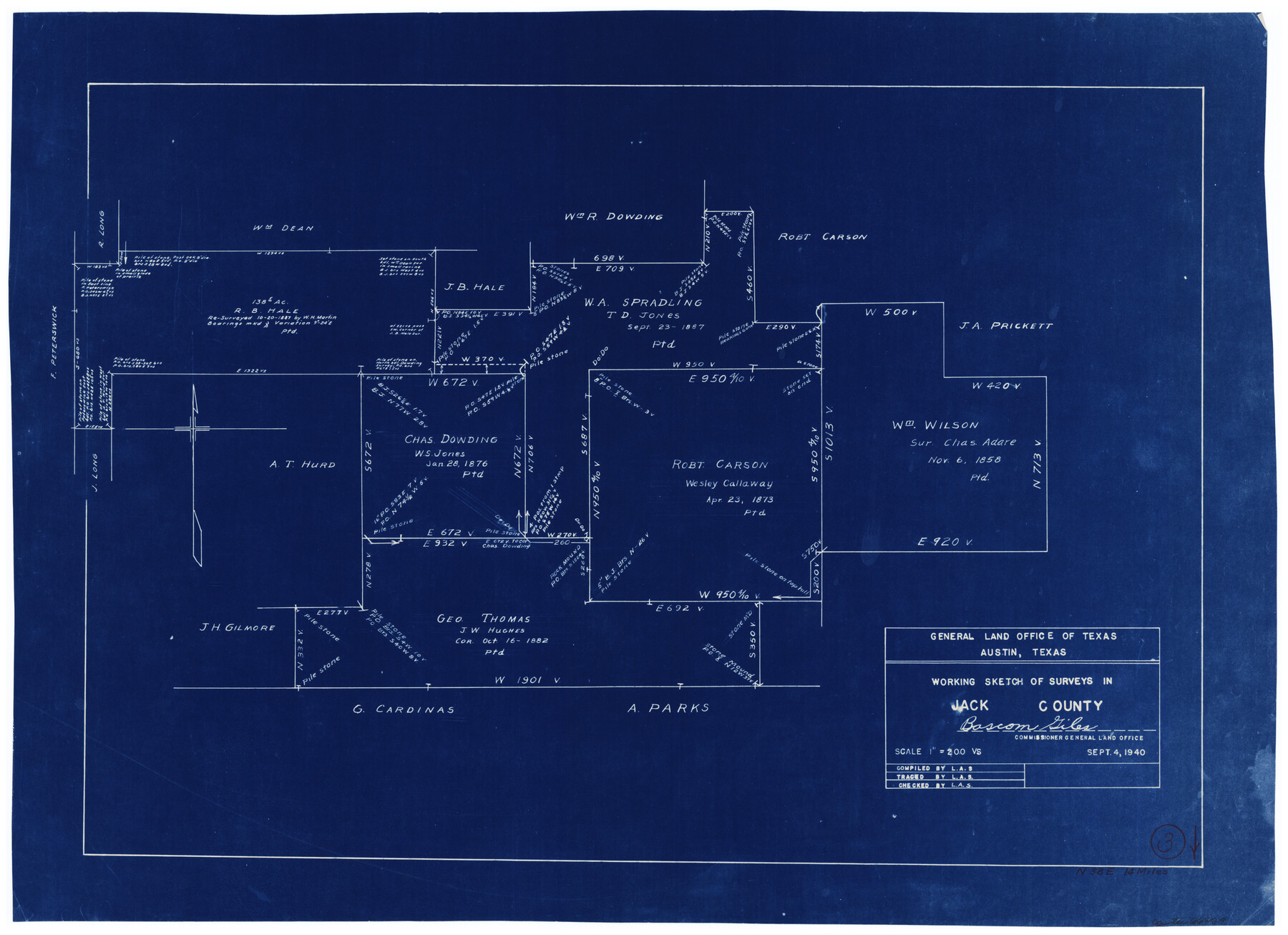
Jack County Working Sketch 3
-
Map/Doc
66429
-
Collection
General Map Collection
-
Object Dates
9/4/1940 (Creation Date)
-
Counties
Jack
-
Subjects
Surveying Working Sketch
-
Height x Width
18.8 x 26.0 inches
47.8 x 66.0 cm
-
Scale
1" = 200 varas
Part of: General Map Collection
Flight Mission No. DQN-5K, Frame 52, Calhoun County

Print $20.00
- Digital $50.00
Flight Mission No. DQN-5K, Frame 52, Calhoun County
1953
Size 18.6 x 22.3 inches
Map/Doc 84397
Flight Mission No. CGI-3N, Frame 180, Cameron County

Print $20.00
- Digital $50.00
Flight Mission No. CGI-3N, Frame 180, Cameron County
1954
Size 18.6 x 22.2 inches
Map/Doc 84644
Milam County Rolled Sketch 3B

Print $20.00
- Digital $50.00
Milam County Rolled Sketch 3B
1967
Size 30.8 x 24.5 inches
Map/Doc 6775
Cooke County Working Sketch 33

Print $20.00
- Digital $50.00
Cooke County Working Sketch 33
1984
Size 25.6 x 28.6 inches
Map/Doc 68270
Victoria County Working Sketch 11

Print $20.00
- Digital $50.00
Victoria County Working Sketch 11
2004
Size 34.7 x 36.0 inches
Map/Doc 83591
Coke County Rolled Sketch 16

Print $20.00
- Digital $50.00
Coke County Rolled Sketch 16
1950
Size 44.0 x 34.3 inches
Map/Doc 8630
Caldwell County Working Sketch 7

Print $20.00
- Digital $50.00
Caldwell County Working Sketch 7
1958
Size 29.7 x 37.2 inches
Map/Doc 67837
Borden County Boundary File 3

Print $62.00
- Digital $50.00
Borden County Boundary File 3
1908
Size 28.7 x 82.9 inches
Map/Doc 1695
Sutton County

Print $40.00
- Digital $50.00
Sutton County
1941
Size 43.9 x 56.1 inches
Map/Doc 73296
Dallas County Sketch File 24

Print $4.00
- Digital $50.00
Dallas County Sketch File 24
1860
Size 14.9 x 8.4 inches
Map/Doc 20459
Collin County Boundary File 18e

Print $16.00
- Digital $50.00
Collin County Boundary File 18e
Size 6.8 x 8.1 inches
Map/Doc 51749
Starr County Working Sketch 14

Print $20.00
- Digital $50.00
Starr County Working Sketch 14
1952
Size 23.4 x 20.9 inches
Map/Doc 63930
You may also like
Harris County Working Sketch 105

Print $20.00
- Digital $50.00
Harris County Working Sketch 105
1980
Size 36.6 x 44.9 inches
Map/Doc 65997
Flight Mission No. DQO-2K, Frame 146, Galveston County

Print $20.00
- Digital $50.00
Flight Mission No. DQO-2K, Frame 146, Galveston County
1952
Size 18.7 x 22.4 inches
Map/Doc 85043
Lamar County State Real Property Sketch 1

Print $20.00
- Digital $50.00
Lamar County State Real Property Sketch 1
2013
Size 24.0 x 36.0 inches
Map/Doc 93657
Refugio County Working Sketch 1

Print $20.00
- Digital $50.00
Refugio County Working Sketch 1
1917
Size 18.8 x 18.0 inches
Map/Doc 63510
Map of Southeastern Part of Young Territory

Print $40.00
- Digital $50.00
Map of Southeastern Part of Young Territory
1874
Size 54.7 x 30.1 inches
Map/Doc 1989
Wood County Boundary File 1

Print $4.00
- Digital $50.00
Wood County Boundary File 1
Size 12.6 x 8.1 inches
Map/Doc 60154
Wilson County Sketch File 13

Print $4.00
- Digital $50.00
Wilson County Sketch File 13
1873
Size 10.2 x 8.0 inches
Map/Doc 40429
Matagorda Light to Aransas Pass

Print $20.00
- Digital $50.00
Matagorda Light to Aransas Pass
1962
Size 35.7 x 44.8 inches
Map/Doc 73397
Kinney County Working Sketch 10

Print $20.00
- Digital $50.00
Kinney County Working Sketch 10
1933
Size 23.1 x 18.4 inches
Map/Doc 70192
Lynn County Boundary File 7

Print $10.00
- Digital $50.00
Lynn County Boundary File 7
Size 11.5 x 8.8 inches
Map/Doc 56642
Goliad County Working Sketch 21

Print $20.00
- Digital $50.00
Goliad County Working Sketch 21
1961
Size 42.9 x 39.6 inches
Map/Doc 63211
[North line of County]
![93142, [North line of County], Twichell Survey Records](https://historictexasmaps.com/wmedia_w700/maps/93142-1.tif.jpg)
Print $40.00
- Digital $50.00
[North line of County]
Size 120.1 x 7.0 inches
Map/Doc 93142