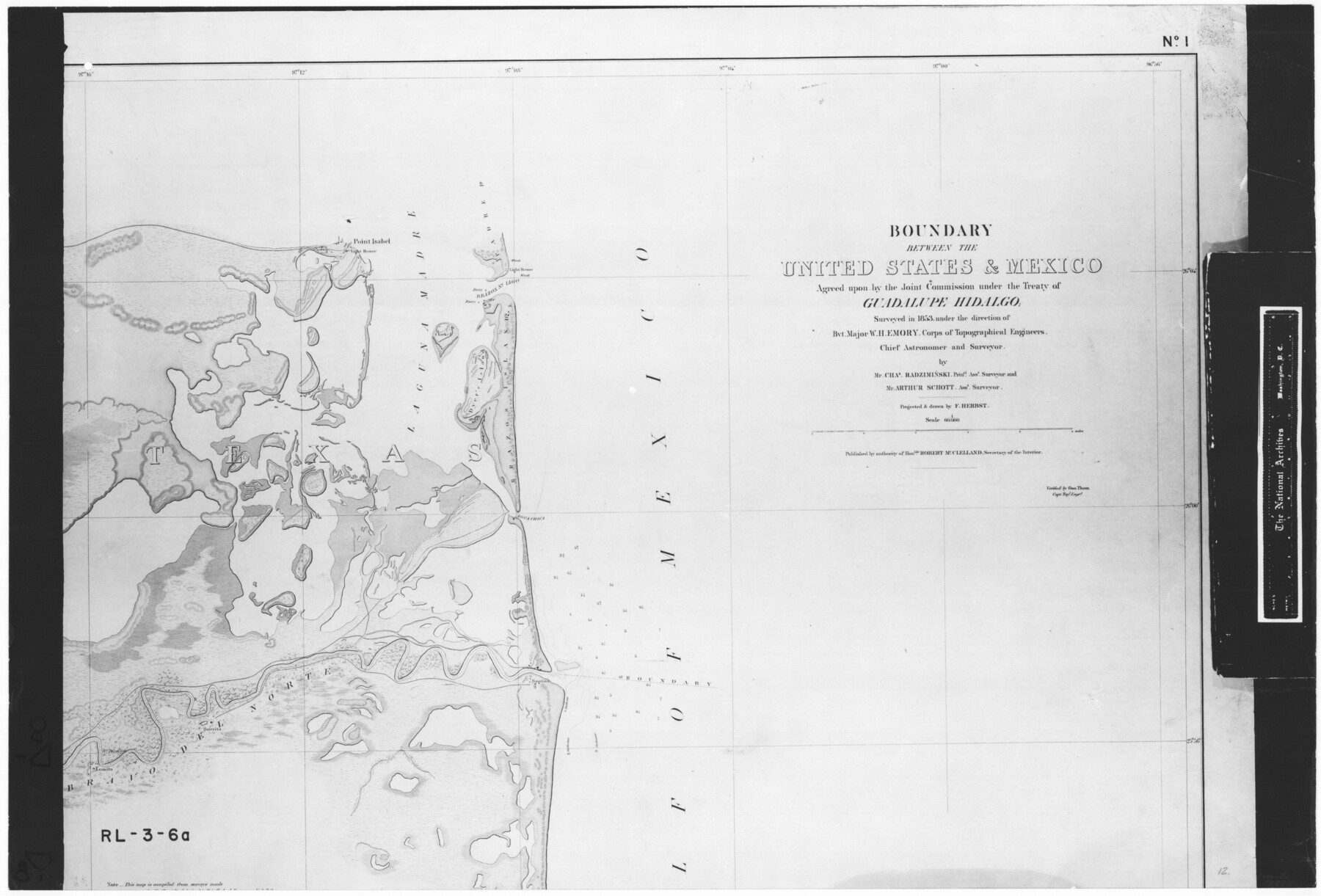
Boundary Between the United States & Mexico Agreed upon by the Joint Commission under the Treaty of Guadalupe Hidalgo
RL-3-6a
-
Map/Doc
72879
-
Collection
General Map Collection
-
Object Dates
1853 (Creation Date)
-
People and Organizations
Department of the Interior (Publisher)
Selmar Siebert (Printer)
Corps of Topographical Engineers (Author)
Francis Herbst (Draftsman)
Arthur Schott (Surveyor/Engineer)
Charles Radziminski (Surveyor/Engineer)
-
Subjects
Texas Boundaries
-
Height x Width
18.2 x 26.8 inches
46.2 x 68.1 cm
-
Comments
B/W photostat copy from National Archives in multiple pieces.
Part of: General Map Collection
Brewster County Rolled Sketch 57

Print $20.00
- Digital $50.00
Brewster County Rolled Sketch 57
1937
Size 43.1 x 37.8 inches
Map/Doc 8482
Uvalde County Boundary File 3

Print $28.00
- Digital $50.00
Uvalde County Boundary File 3
Size 13.1 x 8.4 inches
Map/Doc 59558
Crosby County Working Sketch 17

Print $20.00
- Digital $50.00
Crosby County Working Sketch 17
1982
Size 32.8 x 43.9 inches
Map/Doc 68451
Flight Mission No. DCL-7C, Frame 15, Kenedy County

Print $20.00
- Digital $50.00
Flight Mission No. DCL-7C, Frame 15, Kenedy County
1943
Size 15.4 x 15.3 inches
Map/Doc 86007
Ochiltree County Working Sketch 2

Print $20.00
- Digital $50.00
Ochiltree County Working Sketch 2
1959
Size 23.9 x 20.8 inches
Map/Doc 71315
Edwards County Working Sketch 105

Print $40.00
- Digital $50.00
Edwards County Working Sketch 105
1972
Size 55.3 x 34.2 inches
Map/Doc 68981
Blanco County Sketch File 12

Print $20.00
- Digital $50.00
Blanco County Sketch File 12
Size 15.0 x 19.8 inches
Map/Doc 10928
Walker County Working Sketch 14

Print $40.00
- Digital $50.00
Walker County Working Sketch 14
1958
Size 19.8 x 51.0 inches
Map/Doc 72294
Webb County Sketch File 56

Print $20.00
- Digital $50.00
Webb County Sketch File 56
1940
Size 18.4 x 20.7 inches
Map/Doc 12651
Cottle County Sketch File 3a

Print $14.00
- Digital $50.00
Cottle County Sketch File 3a
Size 12.9 x 8.8 inches
Map/Doc 19459
Dickens County Sketch File 20

Print $2.00
- Digital $50.00
Dickens County Sketch File 20
1911
Size 11.5 x 8.9 inches
Map/Doc 20984
Cottle County Working Sketch 19

Print $20.00
- Digital $50.00
Cottle County Working Sketch 19
1978
Size 33.2 x 29.3 inches
Map/Doc 68329
You may also like
Map of a part of Laguna Madre showing subdivision for mineral development

Print $20.00
- Digital $50.00
Map of a part of Laguna Madre showing subdivision for mineral development
1948
Size 37.4 x 27.7 inches
Map/Doc 2914
East Line of Lipscomb County

Print $20.00
- Digital $50.00
East Line of Lipscomb County
Size 8.9 x 21.8 inches
Map/Doc 91318
Ward County Working Sketch 55

Print $20.00
- Digital $50.00
Ward County Working Sketch 55
1986
Size 30.0 x 36.8 inches
Map/Doc 72361
Frio County Rolled Sketch 13

Print $20.00
- Digital $50.00
Frio County Rolled Sketch 13
1949
Size 36.8 x 26.7 inches
Map/Doc 5920
Castro County Texas

Print $20.00
- Digital $50.00
Castro County Texas
Size 34.0 x 37.5 inches
Map/Doc 92618
Tom Green County Rolled Sketch 25

Print $20.00
- Digital $50.00
Tom Green County Rolled Sketch 25
1882
Size 14.0 x 18.5 inches
Map/Doc 8007
Chambers County Sketch File 55

Print $10.00
- Digital $50.00
Chambers County Sketch File 55
1935
Size 14.3 x 8.6 inches
Map/Doc 18094
Flight Mission No. DQN-3K, Frame 5, Calhoun County

Print $20.00
- Digital $50.00
Flight Mission No. DQN-3K, Frame 5, Calhoun County
1953
Size 18.4 x 22.1 inches
Map/Doc 84337
Crane County Sketch File 26

Print $10.00
- Digital $50.00
Crane County Sketch File 26
1939
Size 11.5 x 9.0 inches
Map/Doc 19598
Young Territory

Print $20.00
- Digital $50.00
Young Territory
1874
Size 29.4 x 29.2 inches
Map/Doc 1977
Crockett County Rolled Sketch LO

Print $20.00
- Digital $50.00
Crockett County Rolled Sketch LO
Size 38.7 x 21.1 inches
Map/Doc 5638
Map of the Republic of Texas Shewing [sic] its division into Counties and Latest Improvements to 1837
![476, Map of the Republic of Texas Shewing [sic] its division into Counties and Latest Improvements to 1837, General Map Collection](https://historictexasmaps.com/wmedia_w700/maps/476-1.tif.jpg)
Print $20.00
- Digital $50.00
Map of the Republic of Texas Shewing [sic] its division into Counties and Latest Improvements to 1837
1837
Size 28.2 x 23.0 inches
Map/Doc 476