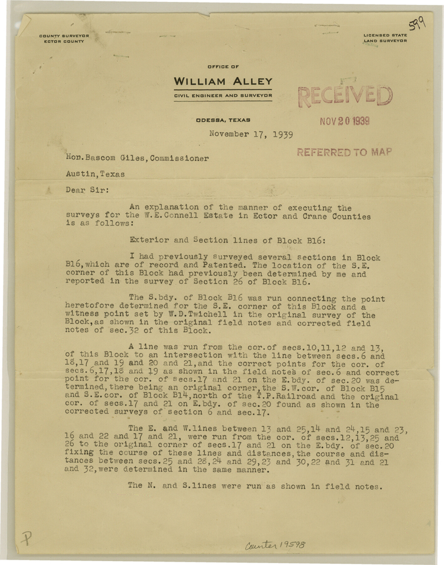
Crane County Sketch File 26
[Report of survey for W. E. Connell estate]
-
Map/Doc
19598
-
Collection
General Map Collection
-
Object Dates
1939/12/6 (Creation Date)
1939/12/8 (File Date)
-
People and Organizations
William Alley (Surveyor/Engineer)
W.D. Twichell (Surveyor/Engineer)
Frank F. Friend (Surveyor/Engineer)
-
Counties
Crane Ector
-
Subjects
Surveying Sketch File
-
Height x Width
11.5 x 9.0 inches
29.2 x 22.9 cm
-
Medium
paper, print
Part of: General Map Collection
Bell County Working Sketch 21

Print $20.00
- Digital $50.00
Bell County Working Sketch 21
2008
Size 41.0 x 29.5 inches
Map/Doc 88887
Flight Mission No. CGI-2N, Frame 155, Cameron County

Print $20.00
- Digital $50.00
Flight Mission No. CGI-2N, Frame 155, Cameron County
1954
Size 18.5 x 22.1 inches
Map/Doc 84537
Dickens County Sketch File 31

Print $20.00
- Digital $50.00
Dickens County Sketch File 31
Size 22.3 x 9.5 inches
Map/Doc 11327
Wilbarger County Sketch File 5a

Print $20.00
- Digital $50.00
Wilbarger County Sketch File 5a
Size 13.4 x 19.7 inches
Map/Doc 12690
Uvalde County Rolled Sketch 24

Print $20.00
- Digital $50.00
Uvalde County Rolled Sketch 24
2014
Size 16.2 x 16.1 inches
Map/Doc 93722
Bosque County Sketch File 15

Print $14.00
- Digital $50.00
Bosque County Sketch File 15
1863
Size 12.3 x 7.7 inches
Map/Doc 14774
Reagan County Sketch File 19

Print $26.00
- Digital $50.00
Reagan County Sketch File 19
1937
Size 14.0 x 28.7 inches
Map/Doc 12220
Flight Mission No. BQR-20K, Frame 5, Brazoria County

Print $20.00
- Digital $50.00
Flight Mission No. BQR-20K, Frame 5, Brazoria County
1952
Size 18.6 x 22.3 inches
Map/Doc 84107
Hutchinson County Working Sketch 17

Print $20.00
- Digital $50.00
Hutchinson County Working Sketch 17
Size 45.8 x 44.2 inches
Map/Doc 66376
Hudspeth County Sketch File 17

Print $11.00
- Digital $50.00
Hudspeth County Sketch File 17
1929
Size 9.3 x 14.6 inches
Map/Doc 26954
Van Zandt County Working Sketch 2

Print $20.00
- Digital $50.00
Van Zandt County Working Sketch 2
1910
Size 17.8 x 11.6 inches
Map/Doc 72251
Gillespie County

Print $40.00
- Digital $50.00
Gillespie County
1945
Size 41.0 x 50.0 inches
Map/Doc 95507
You may also like

Rio Grande Rectification Project, El Paso and Juarez Valley

Print $20.00
- Digital $50.00
Rio Grande Rectification Project, El Paso and Juarez Valley
1935
Size 10.9 x 29.7 inches
Map/Doc 60860
Atascosa County Sketch File 21

Print $40.00
- Digital $50.00
Atascosa County Sketch File 21
Size 20.0 x 19.8 inches
Map/Doc 10859
Matagorda County Sketch File 5

Print $4.00
- Digital $50.00
Matagorda County Sketch File 5
Size 10.0 x 8.0 inches
Map/Doc 30736
El Paso County Rolled Sketch VD

Print $40.00
- Digital $50.00
El Paso County Rolled Sketch VD
1915
Size 18.4 x 67.4 inches
Map/Doc 8862

Map of Liberty County

Print $20.00
- Digital $50.00
Map of Liberty County
Size 27.6 x 26.2 inches
Map/Doc 91079
Baylor County Aerial Photograph Index Sheet 3

Print $20.00
- Digital $50.00
Baylor County Aerial Photograph Index Sheet 3
1950
Size 20.4 x 15.5 inches
Map/Doc 83665
Young County Working Sketch 13

Print $20.00
- Digital $50.00
Young County Working Sketch 13
1938
Size 46.0 x 40.4 inches
Map/Doc 62036
Mexico, California and Texas

Print $20.00
Mexico, California and Texas
1850
Size 11.1 x 15.0 inches
Map/Doc 82964
Henderson County

Print $40.00
- Digital $50.00
Henderson County
1922
Size 33.3 x 62.4 inches
Map/Doc 1854
Jeff Davis County Sketch File 18a

Print $14.00
- Digital $50.00
Jeff Davis County Sketch File 18a
Size 9.3 x 6.0 inches
Map/Doc 27966