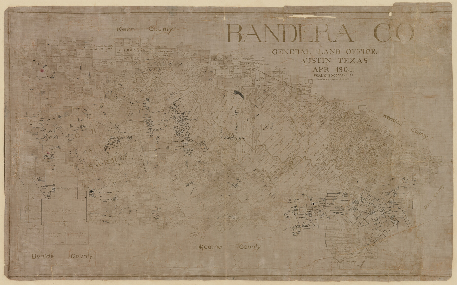
Bandera Co.
-
Map/Doc
4770
-
Collection
General Map Collection
-
Object Dates
1904 (Creation Date)
-
People and Organizations
Texas General Land Office (Publisher)
-
Counties
Bandera
-
Subjects
County
-
Height x Width
31.2 x 50.8 inches
79.2 x 129.0 cm
-
Comments
Traced in September 1918 by Jno. C. Newton.
Copy 2. -
Features
Hondo River
Old San Antonio Road
Winens Creek
Spires Creek
San Julian Creek
Bandera
East Verde Creek
West Prong of Medina River
Middle Verde Creek
Secco Creek
Sabinal River
Ward's Creek
HE&WT
Commissioner's Creek
Thomas Creek
Williams Creek
Medina River
Coker Creek
Bandera Creek
Mason's Creek
Privilege [sic] Creek
Medina
Verde Creek
Part of: General Map Collection
Fannin County Sketch File 8

Print $4.00
- Digital $50.00
Fannin County Sketch File 8
Size 8.7 x 13.3 inches
Map/Doc 22453
Sketch of Surveys on Peach Point, J. Perry's Property

Print $20.00
- Digital $50.00
Sketch of Surveys on Peach Point, J. Perry's Property
1832
Size 14.0 x 20.6 inches
Map/Doc 219
Wilson County Sketch File 8

Print $8.00
- Digital $50.00
Wilson County Sketch File 8
1879
Size 10.4 x 8.2 inches
Map/Doc 40413
Matagorda County Rolled Sketch 9

Print $20.00
- Digital $50.00
Matagorda County Rolled Sketch 9
Size 36.8 x 30.0 inches
Map/Doc 6680
Calhoun County Working Sketch 2b

Print $20.00
- Digital $50.00
Calhoun County Working Sketch 2b
1913
Size 17.3 x 15.8 inches
Map/Doc 67818
Haskell County Working Sketch 15

Print $40.00
- Digital $50.00
Haskell County Working Sketch 15
1983
Size 48.0 x 57.5 inches
Map/Doc 66073
Hutchinson County Working Sketch 7

Print $20.00
- Digital $50.00
Hutchinson County Working Sketch 7
1917
Size 16.5 x 11.9 inches
Map/Doc 66365
Intracoastal Waterway in Texas - Corpus Christi to Point Isabel including Arroyo Colorado to Mo. Pac. R.R. Bridge Near Harlingen

Print $20.00
- Digital $50.00
Intracoastal Waterway in Texas - Corpus Christi to Point Isabel including Arroyo Colorado to Mo. Pac. R.R. Bridge Near Harlingen
1933
Size 28.0 x 40.7 inches
Map/Doc 61848
Coryell County Working Sketch 12

Print $20.00
- Digital $50.00
Coryell County Working Sketch 12
1949
Size 36.0 x 38.7 inches
Map/Doc 68219
Zapata County Working Sketch 1

Print $20.00
- Digital $50.00
Zapata County Working Sketch 1
1912
Size 26.2 x 25.7 inches
Map/Doc 62052
Flight Mission No. BQR-9K, Frame 9, Brazoria County

Print $20.00
- Digital $50.00
Flight Mission No. BQR-9K, Frame 9, Brazoria County
1952
Size 18.6 x 22.3 inches
Map/Doc 84038
Harrison County Rolled Sketch 11

Print $20.00
- Digital $50.00
Harrison County Rolled Sketch 11
1957
Size 24.7 x 30.2 inches
Map/Doc 6154
You may also like
[Beaumont, Sour Lake and Western Ry. Right of Way and Alignment - Frisco]
![64125, [Beaumont, Sour Lake and Western Ry. Right of Way and Alignment - Frisco], General Map Collection](https://historictexasmaps.com/wmedia_w700/maps/64125.tif.jpg)
Print $20.00
- Digital $50.00
[Beaumont, Sour Lake and Western Ry. Right of Way and Alignment - Frisco]
1910
Size 20.1 x 45.9 inches
Map/Doc 64125
Haskell County Sketch File 1

Print $20.00
- Digital $50.00
Haskell County Sketch File 1
1856
Size 19.9 x 10.6 inches
Map/Doc 11738
Matagorda County NRC Article 33.136 Location Key Sheet

Print $20.00
- Digital $50.00
Matagorda County NRC Article 33.136 Location Key Sheet
1973
Size 27.0 x 23.0 inches
Map/Doc 88833
Goliad County

Print $20.00
- Digital $50.00
Goliad County
1946
Size 40.9 x 43.6 inches
Map/Doc 77291
Current Miscellaneous File 38

Print $8.00
- Digital $50.00
Current Miscellaneous File 38
Size 8.6 x 13.0 inches
Map/Doc 73958
[Surveys in the Bexar District along the Pedernales River]
![177, [Surveys in the Bexar District along the Pedernales River], General Map Collection](https://historictexasmaps.com/wmedia_w700/maps/177.tif.jpg)
Print $20.00
- Digital $50.00
[Surveys in the Bexar District along the Pedernales River]
1845
Size 18.7 x 11.0 inches
Map/Doc 177
Travis County Rolled Sketch 13

Print $20.00
- Digital $50.00
Travis County Rolled Sketch 13
Size 28.0 x 20.4 inches
Map/Doc 8016

Flight Mission No. BRE-1P, Frame 66, Nueces County

Print $20.00
- Digital $50.00
Flight Mission No. BRE-1P, Frame 66, Nueces County
1956
Size 18.5 x 22.4 inches
Map/Doc 86648
Victoria County Aerial Photograph Index Sheet 4

Print $20.00
- Digital $50.00
Victoria County Aerial Photograph Index Sheet 4
1953
Size 19.8 x 23.4 inches
Map/Doc 83748
Menard County Rolled Sketch 6

Print $20.00
- Digital $50.00
Menard County Rolled Sketch 6
Size 17.3 x 21.2 inches
Map/Doc 6755
Western Waters of the Clear Fork of the Brazos River below Phantom-Hill

Print $20.00
- Digital $50.00
Western Waters of the Clear Fork of the Brazos River below Phantom-Hill
1857
Size 16.0 x 12.5 inches
Map/Doc 4664