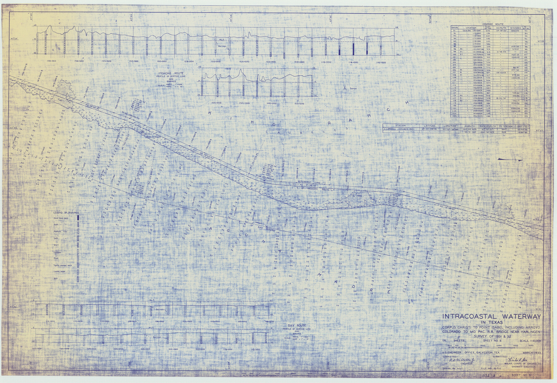
Intracoastal Waterway in Texas - Corpus Christi to Point Isabel including Arroyo Colorado to Mo. Pac. R.R. Bridge Near Harlingen
-
Map/Doc
61848
-
Collection
General Map Collection
-
Object Dates
1933 (Creation Date)
-
Subjects
Intracoastal Waterways
-
Height x Width
28.0 x 40.7 inches
71.1 x 103.4 cm
Part of: General Map Collection
Crane County Rolled Sketch 19

Print $20.00
- Digital $50.00
Crane County Rolled Sketch 19
1926
Size 26.4 x 28.3 inches
Map/Doc 5577
Ellis County Boundary File 2

Print $12.00
- Digital $50.00
Ellis County Boundary File 2
Size 10.7 x 8.3 inches
Map/Doc 52944
Borden County Boundary File 4

Print $66.00
- Digital $50.00
Borden County Boundary File 4
1908
Size 23.7 x 125.7 inches
Map/Doc 1694
Travis County Appraisal District Plat Map 2_0502

Print $20.00
- Digital $50.00
Travis County Appraisal District Plat Map 2_0502
Size 21.4 x 26.4 inches
Map/Doc 94236
[Surveys along the Sabine River made under G.W. Smyth, Commissioner]
![90, [Surveys along the Sabine River made under G.W. Smyth, Commissioner], General Map Collection](https://historictexasmaps.com/wmedia_w700/maps/90.tif.jpg)
Print $20.00
- Digital $50.00
[Surveys along the Sabine River made under G.W. Smyth, Commissioner]
1837
Size 13.9 x 17.0 inches
Map/Doc 90
Flight Mission No. DAH-9M, Frame 202, Orange County

Print $20.00
- Digital $50.00
Flight Mission No. DAH-9M, Frame 202, Orange County
1953
Size 18.5 x 22.6 inches
Map/Doc 86870
Collingsworth County

Print $20.00
- Digital $50.00
Collingsworth County
1971
Size 42.5 x 36.2 inches
Map/Doc 73111
Val Verde County Sketch File 51a

Print $8.00
- Digital $50.00
Val Verde County Sketch File 51a
1959
Size 11.4 x 8.8 inches
Map/Doc 39325
Crosby County Working Sketch 16

Print $40.00
- Digital $50.00
Crosby County Working Sketch 16
1979
Size 37.4 x 59.3 inches
Map/Doc 68450
Hill County Rolled Sketch 1

Print $20.00
- Digital $50.00
Hill County Rolled Sketch 1
1950
Size 13.1 x 41.0 inches
Map/Doc 6214
Menard County Working Sketch 22

Print $20.00
- Digital $50.00
Menard County Working Sketch 22
1950
Size 31.7 x 38.7 inches
Map/Doc 70969
Shelby County Sketch File 24

Print $36.00
- Digital $50.00
Shelby County Sketch File 24
1850
Size 13.0 x 8.1 inches
Map/Doc 36647
You may also like
Falls County Sketch File 24

Print $4.00
- Digital $50.00
Falls County Sketch File 24
1859
Size 13.1 x 8.2 inches
Map/Doc 22428
Goliad County Rolled Sketch 3

Print $4.00
- Digital $50.00
Goliad County Rolled Sketch 3
1945
Size 24.2 x 26.9 inches
Map/Doc 6024
Brewster County Sketch File N-9

Print $40.00
- Digital $50.00
Brewster County Sketch File N-9
Size 17.4 x 15.7 inches
Map/Doc 10964
![[San Benito Promotional Booklet]](https://historictexasmaps.com/wmedia_w700/pdf_converted_jpg/qi_pdf_thumbnail_64211.jpg)
Leon County Sketch File 3

Print $4.00
- Digital $50.00
Leon County Sketch File 3
Size 12.4 x 7.9 inches
Map/Doc 29713
General Highway Map, Hall County, Texas

Print $20.00
General Highway Map, Hall County, Texas
1961
Size 18.2 x 24.6 inches
Map/Doc 79495
Medina County Sketch File 19

Print $20.00
- Digital $50.00
Medina County Sketch File 19
1989
Size 32.5 x 21.0 inches
Map/Doc 12071
Runnels County Rolled Sketch 32

Print $20.00
- Digital $50.00
Runnels County Rolled Sketch 32
Size 34.9 x 44.5 inches
Map/Doc 9868
Spanish and Mexican Land Grants in Texas

Print $20.00
Spanish and Mexican Land Grants in Texas
2015
Size 34.0 x 44.0 inches
Map/Doc 93755
Duval County Working Sketch 18

Print $20.00
- Digital $50.00
Duval County Working Sketch 18
1939
Size 23.5 x 19.6 inches
Map/Doc 68731
Panola County Rolled Sketch 1

Print $20.00
- Digital $50.00
Panola County Rolled Sketch 1
Size 17.5 x 23.9 inches
Map/Doc 7196
[North part of PSL Block A-19 and adjoining School Land Leagues]
![93024, [North part of PSL Block A-19 and adjoining School Land Leagues], Twichell Survey Records](https://historictexasmaps.com/wmedia_w700/maps/93024-1.tif.jpg)
Print $20.00
- Digital $50.00
[North part of PSL Block A-19 and adjoining School Land Leagues]
Size 23.5 x 19.1 inches
Map/Doc 93024