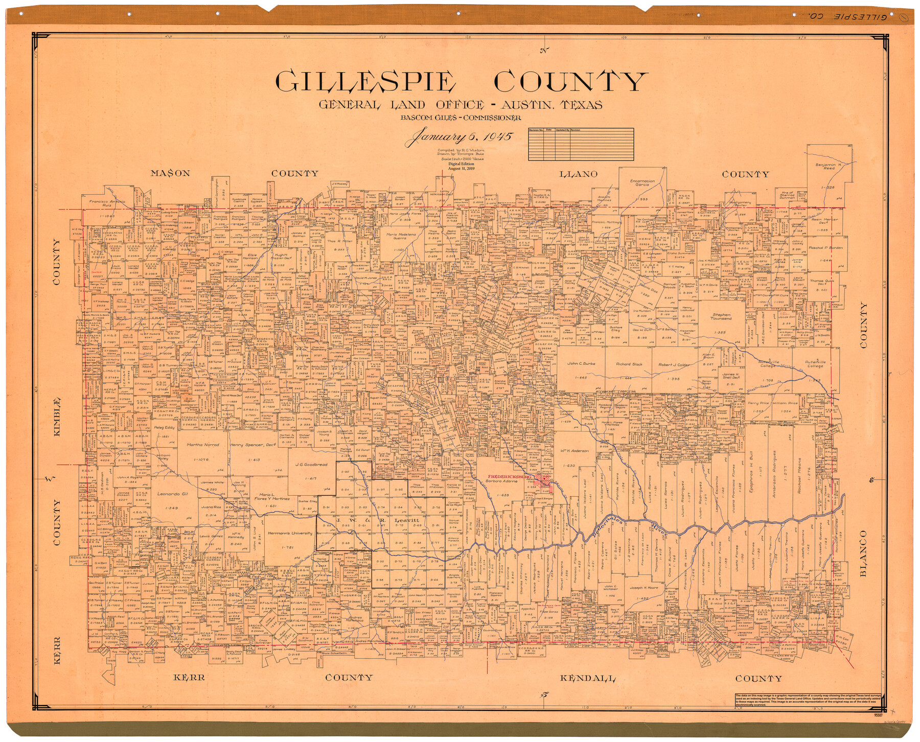
Gillespie County
General Land Office Official County Map
-
Map/Doc
95507
-
Collection
General Map Collection
-
Object Dates
1945/1/6 (Creation Date)
2019/8/31 (Revision Date)
-
People and Organizations
R.C. Wisdom (Compiler)
Tommye Buie (Draftsman)
Cheyenne Betancourt (Draftsman)
Bascom Giles (GLO Commissioner)
-
Counties
Gillespie
-
Subjects
County OCM
-
Height x Width
41.0 x 50.0 inches
104.1 x 127.0 cm
-
Medium
digital image
-
Scale
1" = 2000 varas
Part of: General Map Collection
Comanche County Sketch File 16

Print $6.00
- Digital $50.00
Comanche County Sketch File 16
Size 11.8 x 11.5 inches
Map/Doc 19082
San Jacinto County Working Sketch 3

Print $20.00
- Digital $50.00
San Jacinto County Working Sketch 3
1926
Size 16.7 x 19.7 inches
Map/Doc 63716
Rusk County Sketch File 33

Print $10.00
Rusk County Sketch File 33
1949
Size 11.5 x 8.8 inches
Map/Doc 35568
Reagan County Rolled Sketch 14

Print $20.00
- Digital $50.00
Reagan County Rolled Sketch 14
1942
Size 19.8 x 21.2 inches
Map/Doc 7442
Real County Rolled Sketch 18

Print $20.00
- Digital $50.00
Real County Rolled Sketch 18
Size 22.1 x 28.0 inches
Map/Doc 7467
Brazoria County Rolled Sketch 18

Print $20.00
- Digital $50.00
Brazoria County Rolled Sketch 18
Size 28.0 x 22.5 inches
Map/Doc 5163
Culberson County Working Sketch 70

Print $40.00
- Digital $50.00
Culberson County Working Sketch 70
1975
Size 50.3 x 32.2 inches
Map/Doc 68524
Webb County Rolled Sketch 35

Print $20.00
- Digital $50.00
Webb County Rolled Sketch 35
1939
Size 23.1 x 12.7 inches
Map/Doc 8190
Jack County Working Sketch 5

Print $20.00
- Digital $50.00
Jack County Working Sketch 5
1952
Size 25.7 x 22.1 inches
Map/Doc 66431

Outer Continental Shelf Leasing Maps (Louisiana Offshore Operations)

Print $20.00
- Digital $50.00
Outer Continental Shelf Leasing Maps (Louisiana Offshore Operations)
1954
Size 13.0 x 15.0 inches
Map/Doc 76111
San Jacinto County Rolled Sketch 9

Print $20.00
- Digital $50.00
San Jacinto County Rolled Sketch 9
1944
Size 39.9 x 36.8 inches
Map/Doc 9881
You may also like
Principal Highways of the Southwest with particular reference to New Mexico, Oklahoma, Texas, Arkansas and Louisiana

Print $20.00
Principal Highways of the Southwest with particular reference to New Mexico, Oklahoma, Texas, Arkansas and Louisiana
1933
Size 24.3 x 18.4 inches
Map/Doc 76302
Ochiltree County Sketch File A

Print $22.00
- Digital $50.00
Ochiltree County Sketch File A
1888
Size 8.7 x 5.7 inches
Map/Doc 33167
Working Sketch in Stephens County

Print $20.00
- Digital $50.00
Working Sketch in Stephens County
1919
Size 11.1 x 20.6 inches
Map/Doc 91903
La Salle County Working Sketch 54

Print $20.00
- Digital $50.00
La Salle County Working Sketch 54
2009
Size 23.2 x 46.2 inches
Map/Doc 89048
Wichita County Working Sketch Graphic Index

Print $20.00
- Digital $50.00
Wichita County Working Sketch Graphic Index
1971
Size 36.7 x 38.5 inches
Map/Doc 76739
[Blocks M17, M18, M23, H, I, Z, and XO2]
![91245, [Blocks M17, M18, M23, H, I, Z, and XO2], Twichell Survey Records](https://historictexasmaps.com/wmedia_w700/maps/91245-1.tif.jpg)
Print $20.00
- Digital $50.00
[Blocks M17, M18, M23, H, I, Z, and XO2]
Size 34.5 x 27.2 inches
Map/Doc 91245
Frio County Working Sketch 4

Print $20.00
- Digital $50.00
Frio County Working Sketch 4
1924
Size 26.4 x 27.2 inches
Map/Doc 69278
Ellis County Boundary File 2

Print $12.00
- Digital $50.00
Ellis County Boundary File 2
Size 10.7 x 8.3 inches
Map/Doc 52944
Nueces County Rolled Sketch 76

Print $20.00
- Digital $50.00
Nueces County Rolled Sketch 76
1981
Size 18.3 x 23.6 inches
Map/Doc 6937

Dimmit County Working Sketch 22

Print $20.00
- Digital $50.00
Dimmit County Working Sketch 22
1951
Size 37.3 x 38.7 inches
Map/Doc 68683
General Highway Map, Brown County, Texas

Print $20.00
General Highway Map, Brown County, Texas
1961
Size 24.8 x 18.2 inches
Map/Doc 79389