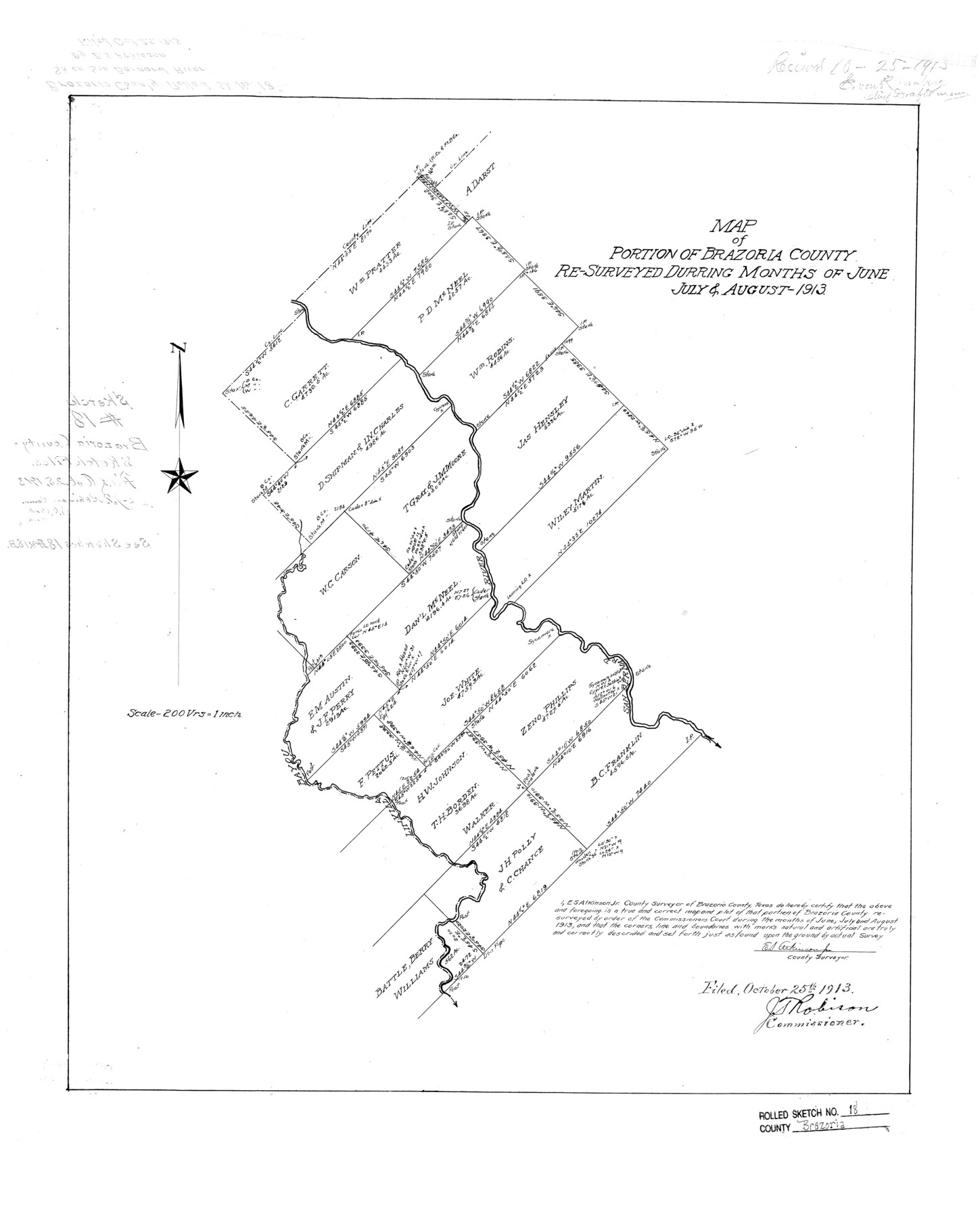
Brazoria County Rolled Sketch 18
Map of portion of Brazoria County re-surveyed during months of June, July & August 1913
-
Map/Doc
5163
-
Collection
General Map Collection
-
Object Dates
10/25/1913 (File Date)
8/1913 (Survey Date)
-
People and Organizations
E.S. Atkinson Jr. (Surveyor/Engineer)
-
Counties
Brazoria
-
Subjects
Surveying Rolled Sketch
-
Height x Width
28.0 x 22.5 inches
71.1 x 57.2 cm
-
Scale
1" = 200 varas
-
Comments
See Bowie County Rolled Sketch 18A (5164) and Bowie County Rolled Sketch 18B (5165) for related sketches.
See also GSC 000002:1 for correspondence regarding the filing of corrected field notes.
Misspelled title: Map of portion of Brazoria County re-surveyed during months of June, July & August 1913
Related maps
Brazoria County Rolled Sketch 18A

Print $20.00
- Digital $50.00
Brazoria County Rolled Sketch 18A
1913
Size 28.3 x 25.1 inches
Map/Doc 5164
Brazoria County Rolled Sketch 18B

Print $20.00
- Digital $50.00
Brazoria County Rolled Sketch 18B
1914
Size 10.0 x 17.3 inches
Map/Doc 5165
Part of: General Map Collection
Crosby County Sketch File 28

Print $20.00
- Digital $50.00
Crosby County Sketch File 28
Size 33.4 x 37.4 inches
Map/Doc 10353
Brown County Sketch File 24

Print $6.00
- Digital $50.00
Brown County Sketch File 24
1889
Size 11.7 x 15.9 inches
Map/Doc 11022
Shackelford County Working Sketch 9

Print $20.00
- Digital $50.00
Shackelford County Working Sketch 9
1974
Size 30.1 x 22.2 inches
Map/Doc 63849
Jasper County Working Sketch 13

Print $20.00
- Digital $50.00
Jasper County Working Sketch 13
1920
Size 24.3 x 17.1 inches
Map/Doc 66475

Cherokee County Working Sketch 6

Print $20.00
- Digital $50.00
Cherokee County Working Sketch 6
1953
Size 40.9 x 35.1 inches
Map/Doc 67961
Limestone County Sketch File 16

Print $4.00
- Digital $50.00
Limestone County Sketch File 16
Size 12.8 x 8.3 inches
Map/Doc 30185
Ochiltree County Rolled Sketch 2

Print $20.00
- Digital $50.00
Ochiltree County Rolled Sketch 2
Size 23.0 x 17.7 inches
Map/Doc 7172
Bee County Sketch File 11

Print $40.00
- Digital $50.00
Bee County Sketch File 11
Size 20.8 x 25.0 inches
Map/Doc 10915
Amistad International Reservoir on Rio Grande 75

Print $20.00
- Digital $50.00
Amistad International Reservoir on Rio Grande 75
1949
Size 28.5 x 40.1 inches
Map/Doc 75503
Fayette County Working Sketch 1

Print $20.00
- Digital $50.00
Fayette County Working Sketch 1
1949
Size 25.4 x 18.0 inches
Map/Doc 69165
Potter County Sketch File 24

Print $13.00
- Digital $50.00
Potter County Sketch File 24
Size 11.0 x 8.5 inches
Map/Doc 82463
You may also like
Nueces County Rolled Sketch 109

Print $20.00
- Digital $50.00
Nueces County Rolled Sketch 109
1989
Size 18.8 x 25.0 inches
Map/Doc 7116
Dimmit County Working Sketch 40

Print $40.00
- Digital $50.00
Dimmit County Working Sketch 40
1968
Size 42.9 x 59.0 inches
Map/Doc 68701
Western Cotton Oil Co. Property Lamb County, Texas

Print $20.00
- Digital $50.00
Western Cotton Oil Co. Property Lamb County, Texas
1951
Size 20.9 x 16.9 inches
Map/Doc 92166
Lamb County Sketch File B

Print $6.00
- Digital $50.00
Lamb County Sketch File B
1902
Size 11.2 x 8.8 inches
Map/Doc 29344
Nueces County Rolled Sketch 66

Print $46.00
- Digital $50.00
Nueces County Rolled Sketch 66
1979
Size 26.1 x 37.4 inches
Map/Doc 9608
Morris County Rolled Sketch 2A

Print $20.00
- Digital $50.00
Morris County Rolled Sketch 2A
Size 24.0 x 18.7 inches
Map/Doc 10277
Montgomery County Sketch File 23

Print $6.00
- Digital $50.00
Montgomery County Sketch File 23
1841
Size 10.2 x 10.8 inches
Map/Doc 31865
Dickens County Sketch File 38

Print $4.00
- Digital $50.00
Dickens County Sketch File 38
1904
Size 10.8 x 7.3 inches
Map/Doc 21048
Webb County Sketch File 46

Print $20.00
- Digital $50.00
Webb County Sketch File 46
1879
Size 19.6 x 14.9 inches
Map/Doc 12644
Presidio County Rolled Sketch 144

Print $20.00
- Digital $50.00
Presidio County Rolled Sketch 144
2010
Size 36.0 x 24.0 inches
Map/Doc 89602
Hall County, Texas

Print $20.00
- Digital $50.00
Hall County, Texas
1880
Size 24.9 x 20.4 inches
Map/Doc 480
Brewster County Sketch File N-5

Print $6.00
- Digital $50.00
Brewster County Sketch File N-5
Size 12.9 x 8.6 inches
Map/Doc 15605