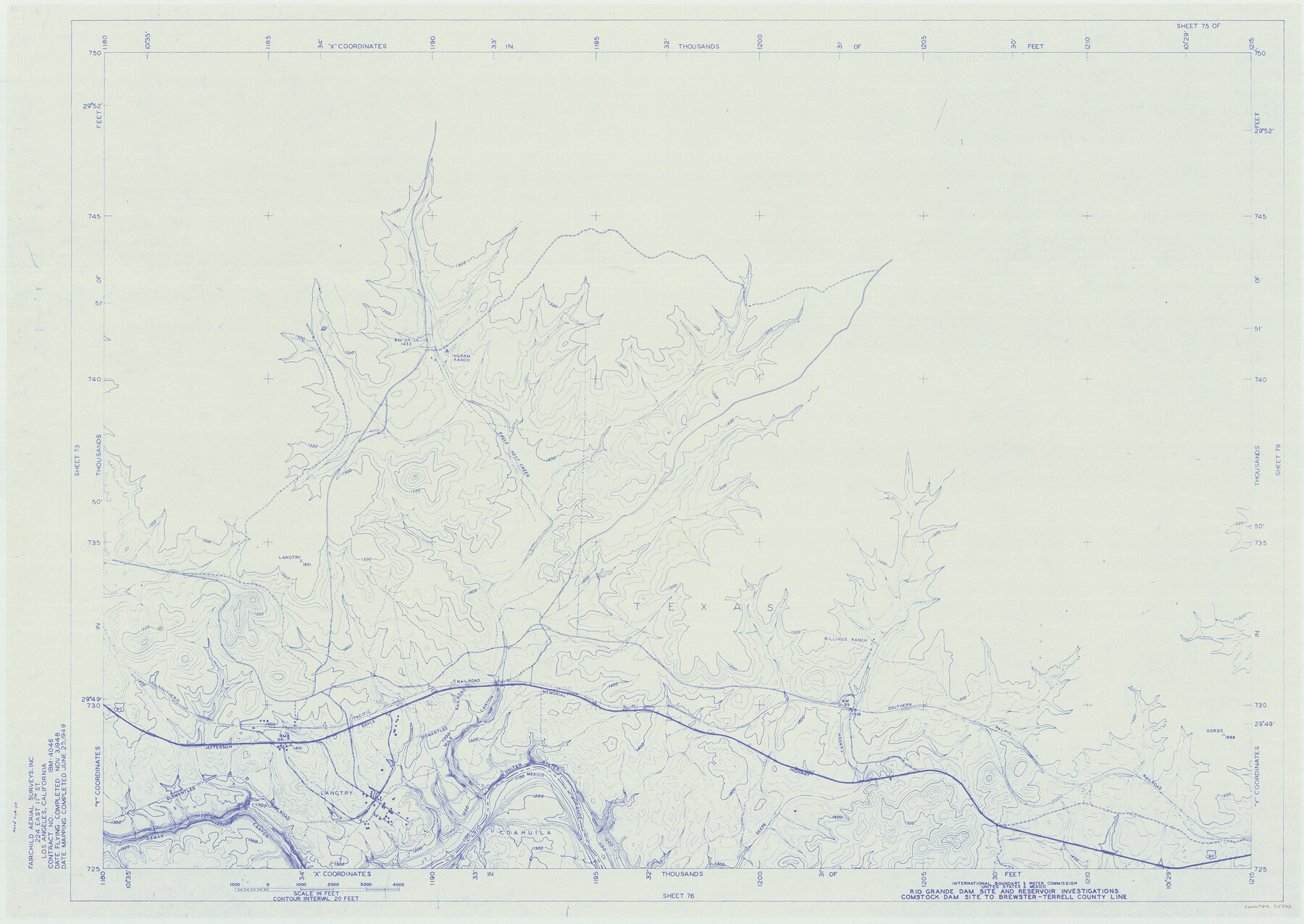
Amistad International Reservoir on Rio Grande 75
Rio Grande Dam Site and Reservoir Investigations
-
Map/Doc
75503
-
Collection
General Map Collection
-
Object Dates
1949/6/25 (Creation Date)
-
People and Organizations
International Boundary and Water Commission (Publisher)
Fairchild Aerial Surveys Inc. (Surveyor/Engineer)
-
Counties
Val Verde
-
Subjects
Texas Boundaries Topographic
-
Height x Width
28.5 x 40.1 inches
72.4 x 101.9 cm
-
Medium
blueline
-
Comments
Comstock Dam site to Brewster-Terrell County line. Shows dismantled railroad bed leading into Langtry.
Part of: General Map Collection
Kimble County Working Sketch 6

Print $20.00
- Digital $50.00
Kimble County Working Sketch 6
1915
Size 24.4 x 26.5 inches
Map/Doc 70074
Liberty County Working Sketch 58

Print $40.00
- Digital $50.00
Liberty County Working Sketch 58
1968
Size 37.3 x 70.3 inches
Map/Doc 70518
Matagorda Light to Aransas Pass

Print $20.00
- Digital $50.00
Matagorda Light to Aransas Pass
1961
Size 35.9 x 44.7 inches
Map/Doc 73396
Pass Cavallo, Entrance to Matagorda Bay, Texas

Print $20.00
- Digital $50.00
Pass Cavallo, Entrance to Matagorda Bay, Texas
1882
Size 24.3 x 18.7 inches
Map/Doc 73375
Sterling County Rolled Sketch 12

Print $20.00
- Digital $50.00
Sterling County Rolled Sketch 12
1941
Size 35.6 x 35.0 inches
Map/Doc 9946
Freestone County Sketch File 19

Print $8.00
- Digital $50.00
Freestone County Sketch File 19
Size 12.4 x 8.1 inches
Map/Doc 23078
Llano County Sketch File 6

Print $8.00
- Digital $50.00
Llano County Sketch File 6
1877
Size 9.4 x 7.9 inches
Map/Doc 30358
Upton County Rolled Sketch 59

Print $40.00
- Digital $50.00
Upton County Rolled Sketch 59
Size 37.8 x 48.4 inches
Map/Doc 10062
Mexican Boundary B. - Extract from the Treaty Map of Disturnell of 1847 referred to in Col. Graham's report to the Hon. The Secretary of the Interior of Aug. 16th, 1851

Print $20.00
- Digital $50.00
Mexican Boundary B. - Extract from the Treaty Map of Disturnell of 1847 referred to in Col. Graham's report to the Hon. The Secretary of the Interior of Aug. 16th, 1851
1851
Size 10.1 x 16.5 inches
Map/Doc 96525
Terrell County Sketch File 24

Print $20.00
- Digital $50.00
Terrell County Sketch File 24
1932
Size 22.0 x 41.8 inches
Map/Doc 10387
Trinity River, Five Mile Creek Sheet

Print $20.00
- Digital $50.00
Trinity River, Five Mile Creek Sheet
1923
Size 20.0 x 40.4 inches
Map/Doc 65197
Presidio County Working Sketch 39

Print $20.00
- Digital $50.00
Presidio County Working Sketch 39
1948
Size 44.6 x 43.4 inches
Map/Doc 71716
You may also like
Flight Mission No. DCL-7C, Frame 97, Kenedy County

Print $20.00
- Digital $50.00
Flight Mission No. DCL-7C, Frame 97, Kenedy County
1943
Size 15.3 x 15.2 inches
Map/Doc 86069
Uvalde County Sketch File 29

Print $8.00
- Digital $50.00
Uvalde County Sketch File 29
1873
Size 13.0 x 8.3 inches
Map/Doc 39028
Dallas County Sketch File 13

Print $12.00
- Digital $50.00
Dallas County Sketch File 13
1866
Size 12.8 x 8.2 inches
Map/Doc 20422
Lynn County Boundary File 4

Print $4.00
- Digital $50.00
Lynn County Boundary File 4
Size 11.3 x 8.7 inches
Map/Doc 56626
Cooke County Sketch File 46

Print $36.00
- Digital $50.00
Cooke County Sketch File 46
2002
Size 10.5 x 8.0 inches
Map/Doc 82578
Jasper County Working Sketch 27

Print $20.00
- Digital $50.00
Jasper County Working Sketch 27
1954
Size 38.3 x 19.4 inches
Map/Doc 66489
Topographic Map, Low Rent Housing Project Texas 18-1, Housing Authority of the City of Lubbock (Plan No. 2)

Print $20.00
- Digital $50.00
Topographic Map, Low Rent Housing Project Texas 18-1, Housing Authority of the City of Lubbock (Plan No. 2)
1941
Size 42.4 x 27.2 inches
Map/Doc 92757
Pecos County Rolled Sketch 123

Print $20.00
- Digital $50.00
Pecos County Rolled Sketch 123
Size 20.3 x 25.4 inches
Map/Doc 7264
Subdivision Map of Childress County School Land situated in Bailey and Cochran Counties, Tex.

Print $20.00
- Digital $50.00
Subdivision Map of Childress County School Land situated in Bailey and Cochran Counties, Tex.
Size 22.8 x 26.2 inches
Map/Doc 90200
[Warren Additions 3 and 4 and vicinity]
![92464, [Warren Additions 3 and 4 and vicinity], Twichell Survey Records](https://historictexasmaps.com/wmedia_w700/maps/92464-1.tif.jpg)
Print $20.00
- Digital $50.00
[Warren Additions 3 and 4 and vicinity]
Size 23.9 x 19.5 inches
Map/Doc 92464
Flight Mission No. DQN-3K, Frame 4, Calhoun County

Print $20.00
- Digital $50.00
Flight Mission No. DQN-3K, Frame 4, Calhoun County
1953
Size 17.0 x 18.9 inches
Map/Doc 84336
Culberson County Sketch File 39

Print $12.00
- Digital $50.00
Culberson County Sketch File 39
1968
Size 11.2 x 8.7 inches
Map/Doc 20306