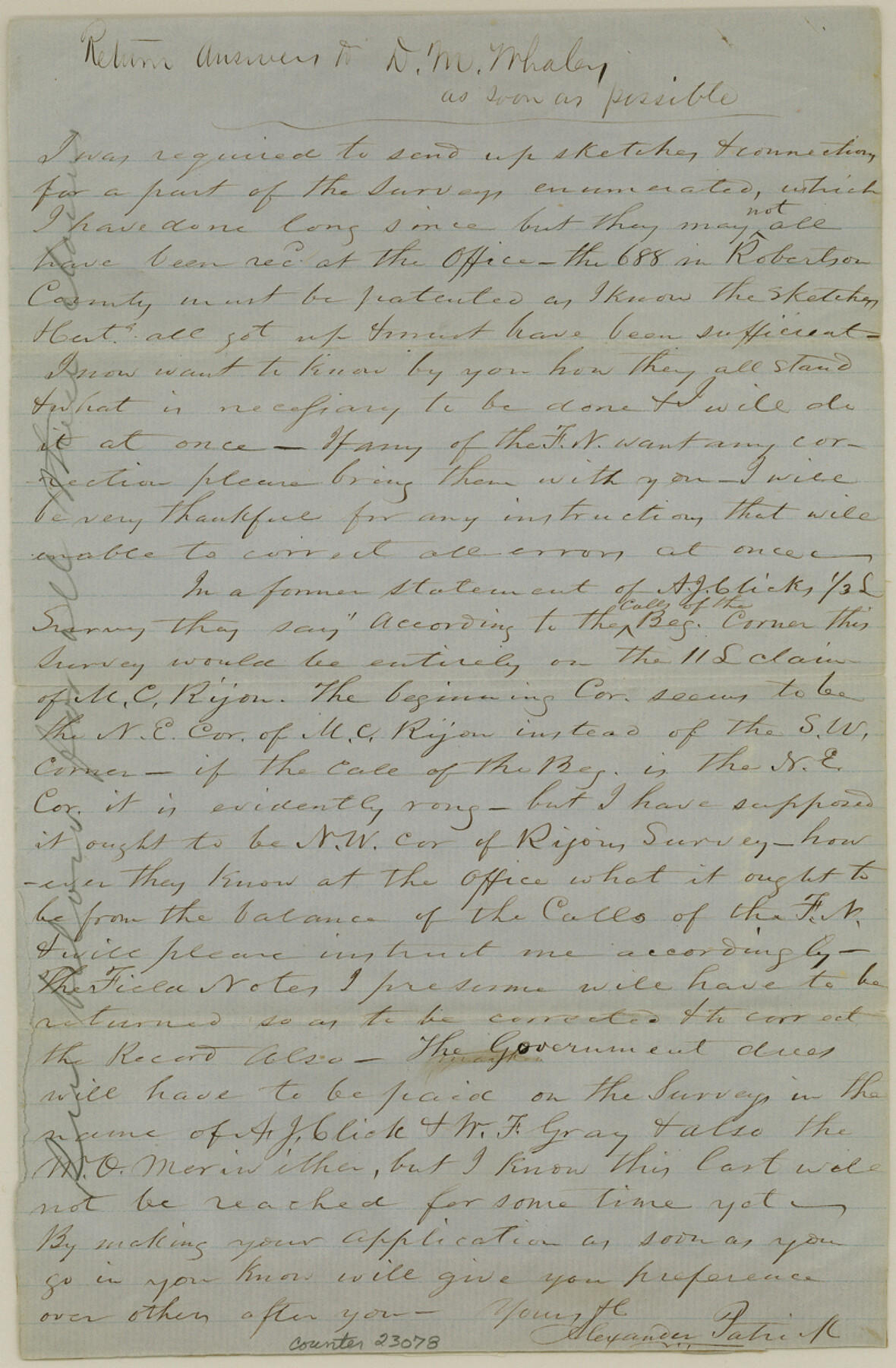
Freestone County Sketch File 19
[Colonel D. M. Whaley's Report]
-
Map/Doc
23078
-
Collection
General Map Collection
-
People and Organizations
Alexander Patrick (Surveyor/Engineer)
-
Counties
Freestone
-
Subjects
Surveying Sketch File
-
Height x Width
12.4 x 8.1 inches
31.5 x 20.6 cm
-
Medium
paper, manuscript
Part of: General Map Collection
Sutton County Working Sketch 59

Print $40.00
- Digital $50.00
Sutton County Working Sketch 59
1957
Size 30.2 x 78.4 inches
Map/Doc 62402
Hood County Working Sketch 13

Print $20.00
- Digital $50.00
Hood County Working Sketch 13
1978
Size 27.6 x 24.5 inches
Map/Doc 66207
Map of the City of Galveston, Texas

Print $20.00
- Digital $50.00
Map of the City of Galveston, Texas
1904
Size 32.0 x 44.0 inches
Map/Doc 73629
Val Verde County Rolled Sketch 71

Print $20.00
- Digital $50.00
Val Verde County Rolled Sketch 71
1958
Size 19.5 x 19.5 inches
Map/Doc 8133
Hopkins County

Print $20.00
- Digital $50.00
Hopkins County
1942
Size 43.6 x 41.6 inches
Map/Doc 1858
Taylor County Sketch File 15

Print $12.00
- Digital $50.00
Taylor County Sketch File 15
1881
Size 10.1 x 8.1 inches
Map/Doc 37805
Scurry County Sketch File 5

Print $4.00
- Digital $50.00
Scurry County Sketch File 5
1990
Size 14.4 x 8.9 inches
Map/Doc 36568
Colonial Texas. 1822 to 1834.

Print $20.00
- Digital $50.00
Colonial Texas. 1822 to 1834.
1897
Size 12.8 x 16.3 inches
Map/Doc 93410
Galveston County NRC Article 33.136 Sketch 41

Print $28.00
- Digital $50.00
Galveston County NRC Article 33.136 Sketch 41
2006
Size 29.8 x 42.4 inches
Map/Doc 83074
Comanche County Working Sketch 2

Print $20.00
- Digital $50.00
Comanche County Working Sketch 2
1918
Size 15.0 x 21.5 inches
Map/Doc 68136
Freestone County Working Sketch 10

Print $20.00
- Digital $50.00
Freestone County Working Sketch 10
1978
Size 40.6 x 33.1 inches
Map/Doc 69252
Sherman County

Print $20.00
- Digital $50.00
Sherman County
1902
Size 41.0 x 36.7 inches
Map/Doc 63035
You may also like
Capitol Lands Surveyed by J. T. Munson

Print $20.00
- Digital $50.00
Capitol Lands Surveyed by J. T. Munson
Size 15.5 x 16.7 inches
Map/Doc 90524
Sutton County Sketch File 57

Print $24.00
- Digital $50.00
Sutton County Sketch File 57
1961
Size 11.2 x 8.8 inches
Map/Doc 37542
Map of Rains County

Print $20.00
- Digital $50.00
Map of Rains County
1873
Size 12.0 x 12.4 inches
Map/Doc 4619
Polk County Working Sketch 33b

Print $20.00
- Digital $50.00
Polk County Working Sketch 33b
1960
Size 14.9 x 24.8 inches
Map/Doc 71650
Flight Mission No. BRA-16M, Frame 162, Jefferson County

Print $20.00
- Digital $50.00
Flight Mission No. BRA-16M, Frame 162, Jefferson County
1953
Size 18.6 x 22.3 inches
Map/Doc 85760
Map of Potter County

Print $20.00
- Digital $50.00
Map of Potter County
1895
Size 23.6 x 18.4 inches
Map/Doc 4617
Real County Working Sketch 38

Print $20.00
- Digital $50.00
Real County Working Sketch 38
1951
Size 34.0 x 37.9 inches
Map/Doc 71930
Liberty County Rolled Sketch 2S

Print $20.00
- Digital $50.00
Liberty County Rolled Sketch 2S
1958
Size 32.0 x 40.6 inches
Map/Doc 10660
Duval County Working Sketch 42

Print $20.00
- Digital $50.00
Duval County Working Sketch 42
1976
Size 24.9 x 31.1 inches
Map/Doc 68766
[Beaumont, Sour Lake and Western Ry. Right of Way and Alignment - Frisco]
![64128, [Beaumont, Sour Lake and Western Ry. Right of Way and Alignment - Frisco], General Map Collection](https://historictexasmaps.com/wmedia_w700/maps/64128.tif.jpg)
Print $20.00
- Digital $50.00
[Beaumont, Sour Lake and Western Ry. Right of Way and Alignment - Frisco]
1910
Size 20.1 x 45.9 inches
Map/Doc 64128
Montague County Working Sketch 34

Print $20.00
- Digital $50.00
Montague County Working Sketch 34
1979
Size 20.3 x 15.0 inches
Map/Doc 71100
Flight Mission No. CLL-1N, Frame 31, Willacy County

Print $20.00
- Digital $50.00
Flight Mission No. CLL-1N, Frame 31, Willacy County
1954
Size 18.5 x 22.2 inches
Map/Doc 87012