Sutton County Sketch File 57
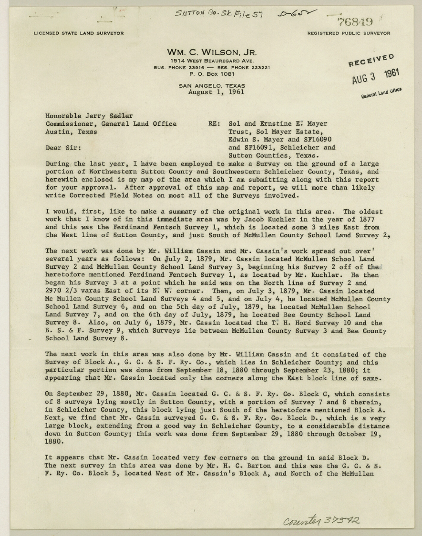
[Report of resurvey of Mayer Estate in Sutton and Schleicher Counties]
-
Map/Doc
37542
-
Collection
General Map Collection
-
Object Dates
1909/3/5 (Survey Date)
1961/8/3 (File Date)
1912/1/15 (File Date)
1947/4/16 (Survey Date)
1960 (Survey Date)
1959 (Survey Date)
1956 (Survey Date)
1952 (Survey Date)
1952 (Survey Date)
1948/9/29 (Survey Date)
1926/8/7 (Survey Date)
1947 (Survey Date)
1946 (Survey Date)
1894/1/22 (Survey Date)
1909/10/9 (Survey Date)
1961/8/1 (Creation Date)
1907/7/17 (Survey Date)
1906 (Survey Date)
1888/4/3 (Survey Date)
1881/1/8 (Survey Date)
1890/11/26 (Survey Date)
1881 (Survey Date)
1882 (Survey Date)
1880/8/19 (Survey Date)
1880/9/23 (Survey Date)
1879/7/6 (Survey Date)
1877 (Survey Date)
1961/8/1 (Correspondence Date)
1961/8/3 (File Date)
-
People and Organizations
James P. Dodd (Surveyor/Engineer)
Wm. C. Wilson, Jr. (Surveyor/Engineer)
Jacob Kuchler [sic] (Surveyor/Engineer)
William Cassin (Surveyor/Engineer)
H.C. Barton (Surveyor/Engineer)
S.A. Thompson (Surveyor/Engineer)
W.H. Bonnell (Surveyor/Engineer)
J. Campbell (Surveyor/Engineer)
J. McNichol (Surveyor/Engineer)
H.M. Garden (Surveyor/Engineer)
James K. Avera (Surveyor/Engineer)
G.D. Hines (Surveyor/Engineer)
J.A. Conklin (Surveyor/Engineer)
John P. Pool (Surveyor/Engineer)
Clifford C. Cool (Surveyor/Engineer)
E.S. Mayer (Draftsman)
Edgar S. Saunders (Draftsman)
-
Counties
Sutton Schleicher Crockett
-
Subjects
Surveying Sketch File
-
Height x Width
11.2 x 8.8 inches
28.5 x 22.4 cm
-
Medium
paper, print
-
Comments
See Sutton County Rolled Sketch 59 (9977) for sketch.
Related maps
Sutton County Rolled Sketch 59

Print $40.00
- Digital $50.00
Sutton County Rolled Sketch 59
1960
Size 86.1 x 42.5 inches
Map/Doc 9977
Part of: General Map Collection
Edwards County Working Sketch 43

Print $20.00
- Digital $50.00
Edwards County Working Sketch 43
1950
Size 20.3 x 27.7 inches
Map/Doc 68919
Starr County Rolled Sketch 40

Print $20.00
- Digital $50.00
Starr County Rolled Sketch 40
1961
Size 21.3 x 22.6 inches
Map/Doc 7834
Jasper County Working Sketch 25

Print $20.00
- Digital $50.00
Jasper County Working Sketch 25
1951
Size 21.6 x 32.3 inches
Map/Doc 66487
Map of the River Sabine from its mouth on the Gulf of Mexico in the Sea to Logan's Ferry in Latitude 31°58'24" North

Print $40.00
- Digital $50.00
Map of the River Sabine from its mouth on the Gulf of Mexico in the Sea to Logan's Ferry in Latitude 31°58'24" North
1842
Size 173.2 x 31.0 inches
Map/Doc 1744
Flight Mission No. CGI-3N, Frame 175, Cameron County

Print $20.00
- Digital $50.00
Flight Mission No. CGI-3N, Frame 175, Cameron County
1954
Size 18.6 x 22.3 inches
Map/Doc 84639
New Oil and Geological Map of Texas showing Oil Fields, Pipe Lines, Refineries, Geological Formations, Etc.

Print $20.00
- Digital $50.00
New Oil and Geological Map of Texas showing Oil Fields, Pipe Lines, Refineries, Geological Formations, Etc.
1920
Size 22.5 x 31.3 inches
Map/Doc 96633
Flight Mission No. DQN-1K, Frame 152, Calhoun County

Print $20.00
- Digital $50.00
Flight Mission No. DQN-1K, Frame 152, Calhoun County
1953
Size 18.6 x 22.3 inches
Map/Doc 84211
Flight Mission No. DIX-10P, Frame 183, Aransas County

Print $20.00
- Digital $50.00
Flight Mission No. DIX-10P, Frame 183, Aransas County
1956
Size 18.4 x 22.1 inches
Map/Doc 83973
Deaf Smith County

Print $40.00
- Digital $50.00
Deaf Smith County
1926
Size 38.5 x 50.3 inches
Map/Doc 95477
Pecos County Rolled Sketch 85

Print $20.00
- Digital $50.00
Pecos County Rolled Sketch 85
1931
Size 36.7 x 24.4 inches
Map/Doc 7243
Washington County

Print $20.00
- Digital $50.00
Washington County
1871
Size 11.9 x 27.7 inches
Map/Doc 4123
Atascosa County Working Sketch 39

Print $20.00
- Digital $50.00
Atascosa County Working Sketch 39
2011
Size 43.2 x 34.8 inches
Map/Doc 90068
You may also like
Working Sketch in Archer County

Print $20.00
- Digital $50.00
Working Sketch in Archer County
1924
Size 30.3 x 42.2 inches
Map/Doc 90171
Aransas County Working Sketch 11

Print $20.00
- Digital $50.00
Aransas County Working Sketch 11
1949
Size 17.3 x 18.7 inches
Map/Doc 67178
Hudspeth County Sketch File 30

Print $8.00
- Digital $50.00
Hudspeth County Sketch File 30
1950
Size 11.3 x 8.8 inches
Map/Doc 26986
Galveston County Rolled Sketch 26

Print $950.00
- Digital $50.00
Galveston County Rolled Sketch 26
Size 10.6 x 16.1 inches
Map/Doc 44849
Trinity River, Owen Crossing Sheet/Elm Fork of Trinity River

Print $20.00
- Digital $50.00
Trinity River, Owen Crossing Sheet/Elm Fork of Trinity River
1914
Size 29.1 x 31.4 inches
Map/Doc 65201
Harris County Sketch File 91

Print $141.00
- Digital $50.00
Harris County Sketch File 91
1980
Size 11.3 x 8.9 inches
Map/Doc 25600
Pecos County Rolled Sketch 103

Print $20.00
- Digital $50.00
Pecos County Rolled Sketch 103
1940
Size 27.5 x 32.4 inches
Map/Doc 7251
Travis County Rolled Sketch 35

Print $20.00
- Digital $50.00
Travis County Rolled Sketch 35
1949
Size 22.8 x 24.6 inches
Map/Doc 8036

Ashburn's San Antonio City Map

Ashburn's San Antonio City Map
1951
Size 24.5 x 19.5 inches
Map/Doc 97144
Controlled Mosaic by Jack Amman Photogrammetric Engineers, Inc - Sheet 42

Print $20.00
- Digital $50.00
Controlled Mosaic by Jack Amman Photogrammetric Engineers, Inc - Sheet 42
1954
Size 20.0 x 24.0 inches
Map/Doc 83501
