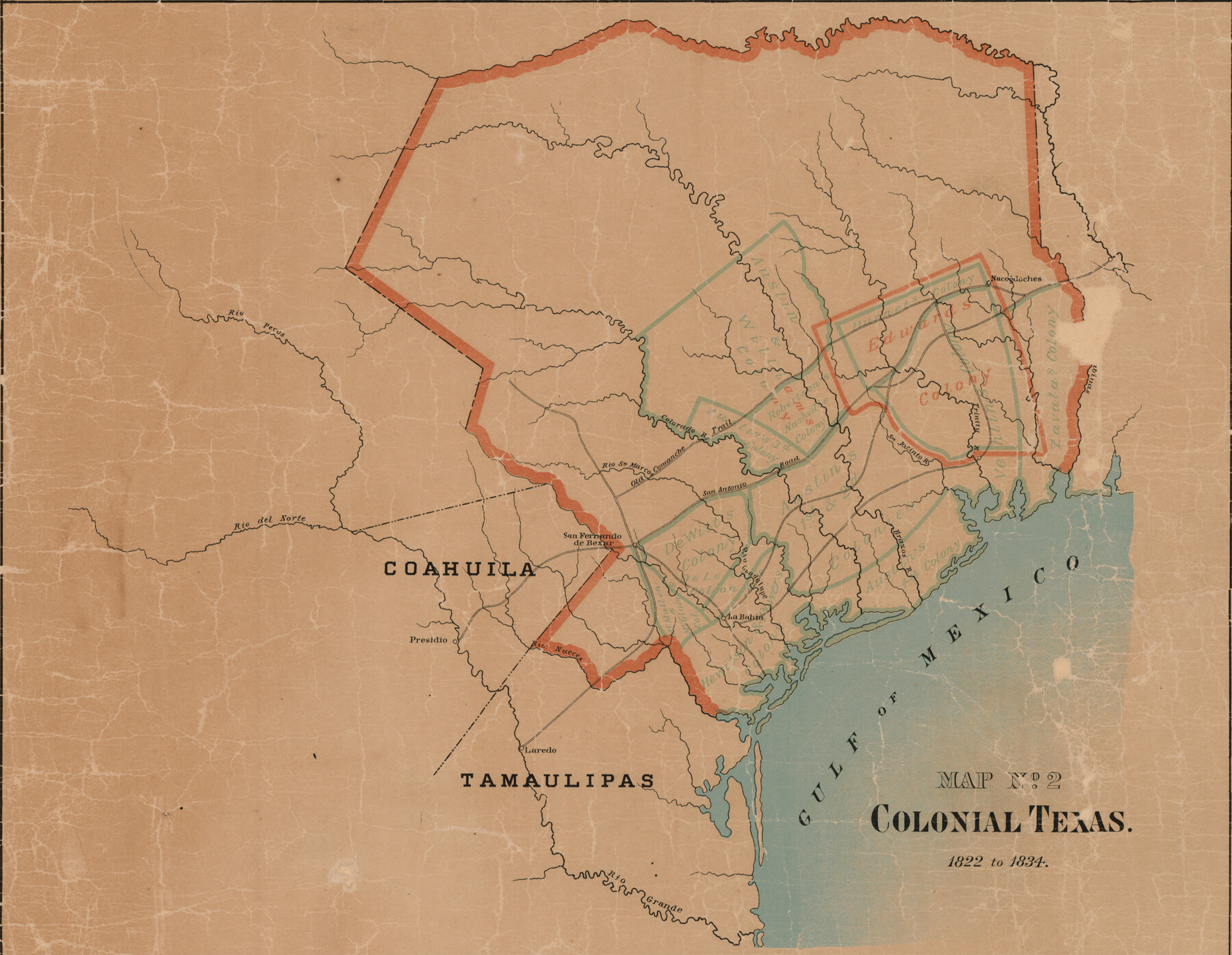
Colonial Texas. 1822 to 1834.
K-4-34
-
Map/Doc
93410
-
Collection
General Map Collection
-
Object Dates
1897 (Creation Date)
-
People and Organizations
The Caxton Company (Publisher)
Z.T. Fulmore (Draftsman)
-
Subjects
Mexican Texas
-
Height x Width
12.8 x 16.3 inches
32.5 x 41.4 cm
-
Comments
This map was cropped from Map 3095 "History of the Geography of Texas".
Related maps
History of the Geography of Texas

Print $40.00
- Digital $50.00
History of the Geography of Texas
1897
Size 70.7 x 52.9 inches
Map/Doc 3095
Part of: General Map Collection
Guadalupe County Working Sketch 3

Print $20.00
- Digital $50.00
Guadalupe County Working Sketch 3
1980
Size 17.1 x 16.5 inches
Map/Doc 63312
Flight Mission No. DQN-5K, Frame 40, Calhoun County

Print $20.00
- Digital $50.00
Flight Mission No. DQN-5K, Frame 40, Calhoun County
1953
Size 18.6 x 22.1 inches
Map/Doc 84388
Photo Index of Texas Coast - Sheet 6 of 6

Print $20.00
- Digital $50.00
Photo Index of Texas Coast - Sheet 6 of 6
1954
Size 20.0 x 24.0 inches
Map/Doc 83444
Brewster County Rolled Sketch 123

Print $25.00
- Digital $50.00
Brewster County Rolled Sketch 123
Size 10.1 x 15.3 inches
Map/Doc 43129
Hutchinson County Sketch File 25

Print $6.00
- Digital $50.00
Hutchinson County Sketch File 25
1922
Size 11.2 x 8.8 inches
Map/Doc 27258
Leon County Sketch File 35-2

Print $20.00
- Digital $50.00
Leon County Sketch File 35-2
1966
Size 24.3 x 20.4 inches
Map/Doc 11994
Jefferson County Rolled Sketch 39

Print $20.00
- Digital $50.00
Jefferson County Rolled Sketch 39
1885
Size 31.6 x 34.3 inches
Map/Doc 9300
Hunt County Boundary File 8

Print $8.00
- Digital $50.00
Hunt County Boundary File 8
Size 14.6 x 8.9 inches
Map/Doc 55237
Wheeler County Sketch File 7

Print $20.00
- Digital $50.00
Wheeler County Sketch File 7
Size 38.1 x 47.7 inches
Map/Doc 10431
Falls County Working Sketch Graphic Index

Print $20.00
- Digital $50.00
Falls County Working Sketch Graphic Index
1976
Size 39.7 x 44.2 inches
Map/Doc 76539
Caldwell County Working Sketch 12

Print $20.00
- Digital $50.00
Caldwell County Working Sketch 12
1979
Size 47.7 x 44.2 inches
Map/Doc 67842
Randall County

Print $20.00
- Digital $50.00
Randall County
1917
Size 45.2 x 38.9 inches
Map/Doc 73339
You may also like

General Highway Map, Calhoun County, Texas

Print $20.00
General Highway Map, Calhoun County, Texas
1940
Size 18.5 x 25.3 inches
Map/Doc 79036
Ward County Rolled Sketch 9

Print $40.00
- Digital $50.00
Ward County Rolled Sketch 9
1936
Size 51.5 x 41.9 inches
Map/Doc 10105
Lubbock County

Print $20.00
- Digital $50.00
Lubbock County
1879
Size 21.3 x 19.1 inches
Map/Doc 4583
Nueces County Rolled Sketch 70

Print $60.00
Nueces County Rolled Sketch 70
1980
Size 25.3 x 38.0 inches
Map/Doc 6921
Hudspeth County Rolled Sketch 70

Print $40.00
- Digital $50.00
Hudspeth County Rolled Sketch 70
1982
Size 38.1 x 47.7 inches
Map/Doc 9233
Polk County Working Sketch 11

Print $20.00
- Digital $50.00
Polk County Working Sketch 11
1940
Size 29.3 x 28.6 inches
Map/Doc 71626
Travis County Working Sketch 28

Print $20.00
- Digital $50.00
Travis County Working Sketch 28
1955
Size 31.5 x 30.7 inches
Map/Doc 69412
Hoffman & Walker's Pictorial, Historical Map of Texas

Hoffman & Walker's Pictorial, Historical Map of Texas
1960
Size 43.4 x 45.3 inches
Map/Doc 93275
Flight Mission No. BQR-7K, Frame 30, Brazoria County

Print $20.00
- Digital $50.00
Flight Mission No. BQR-7K, Frame 30, Brazoria County
1952
Size 18.6 x 22.3 inches
Map/Doc 84028
Schleicher County Sketch File 15

Print $22.00
- Digital $50.00
Schleicher County Sketch File 15
1928
Size 8.1 x 12.9 inches
Map/Doc 36504
Working Sketch from Lynn & Garza Counties

Print $20.00
- Digital $50.00
Working Sketch from Lynn & Garza Counties
1902
Size 35.8 x 30.6 inches
Map/Doc 93223