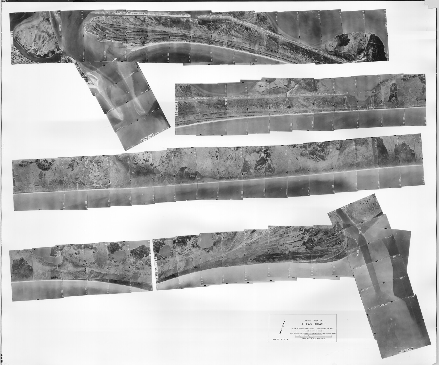
Photo Index of Texas Coast - Sheet 6 of 6
Photo Index of Texas Coast, Sheet 6 of 6
-
Map/Doc
83444
-
Collection
General Map Collection
-
Object Dates
1954 (Creation Date)
-
Subjects
Aerial Photograph
-
Height x Width
20.0 x 24.0 inches
50.8 x 61.0 cm
-
Comments
Statement on reverse side: "The reverse reflects the data shown thereon which was obtained by aerial survey made from December 31, 1953 to March 17, 1954 by Jack Ammann Photogrammetric Engineers, Inc."
Part of: General Map Collection
Flight Mission No. CRC-4R, Frame 75, Chambers County

Print $20.00
- Digital $50.00
Flight Mission No. CRC-4R, Frame 75, Chambers County
1956
Size 18.6 x 22.3 inches
Map/Doc 84879
Zapata County Boundary File 1

Print $2.00
- Digital $50.00
Zapata County Boundary File 1
Size 11.4 x 9.0 inches
Map/Doc 60227
Goliad County Working Sketch 25

Print $20.00
- Digital $50.00
Goliad County Working Sketch 25
1994
Size 19.6 x 21.9 inches
Map/Doc 63215
Live Oak County Working Sketch 39

Print $40.00
- Digital $50.00
Live Oak County Working Sketch 39
2006
Size 36.4 x 48.6 inches
Map/Doc 94156
Galveston County Sketch File 67

Print $4.00
- Digital $50.00
Galveston County Sketch File 67
1988
Size 11.3 x 8.7 inches
Map/Doc 23782
Brewster County Rolled Sketch 121
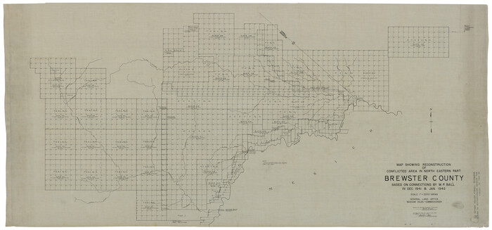
Print $40.00
- Digital $50.00
Brewster County Rolled Sketch 121
1942
Size 43.3 x 92.8 inches
Map/Doc 93790
Nolan County Sketch File 18

Print $8.00
- Digital $50.00
Nolan County Sketch File 18
Size 14.3 x 8.9 inches
Map/Doc 32489
Rio Grande Rectification Project, El Paso and Juarez Valley

Print $20.00
- Digital $50.00
Rio Grande Rectification Project, El Paso and Juarez Valley
1935
Size 10.7 x 29.7 inches
Map/Doc 60863
Starr County Sketch File 9

Print $22.00
- Digital $50.00
Starr County Sketch File 9
Size 9.1 x 7.9 inches
Map/Doc 36861
Copy of Surveyor's Field Book, Morris Browning - In Blocks 7, 5 & 4, I&GNRRCo., Hutchinson and Carson Counties, Texas

Print $2.00
- Digital $50.00
Copy of Surveyor's Field Book, Morris Browning - In Blocks 7, 5 & 4, I&GNRRCo., Hutchinson and Carson Counties, Texas
1888
Size 6.9 x 8.8 inches
Map/Doc 62271
Anderson County Working Sketch 31

Print $20.00
- Digital $50.00
Anderson County Working Sketch 31
1966
Size 18.3 x 23.2 inches
Map/Doc 67031
El Paso County Sketch File 30

Print $4.00
- Digital $50.00
El Paso County Sketch File 30
1960
Size 11.2 x 8.8 inches
Map/Doc 22082
You may also like
Marion County Working Sketch 19

Print $20.00
- Digital $50.00
Marion County Working Sketch 19
1958
Size 29.0 x 23.6 inches
Map/Doc 70795
Bexar County Working Sketch 2

Print $20.00
- Digital $50.00
Bexar County Working Sketch 2
1940
Size 24.8 x 27.9 inches
Map/Doc 67318
Denton County Sketch File 25

Print $4.00
- Digital $50.00
Denton County Sketch File 25
1863
Size 8.0 x 7.4 inches
Map/Doc 20752
The Judicial District/County of Trinity. Created, December 7, 1841

Print $20.00
The Judicial District/County of Trinity. Created, December 7, 1841
2020
Size 14.7 x 21.7 inches
Map/Doc 96350
Sabine and Neches Rivers

Print $20.00
- Digital $50.00
Sabine and Neches Rivers
1971
Size 19.7 x 44.4 inches
Map/Doc 69817
United States - Gulf Coast - Padre I. and Laguna Madre Lat. 27° 12' to Lat. 26° 33' Texas

Print $20.00
- Digital $50.00
United States - Gulf Coast - Padre I. and Laguna Madre Lat. 27° 12' to Lat. 26° 33' Texas
1913
Size 26.8 x 18.4 inches
Map/Doc 72817
Travis County Working Sketch 60

Print $20.00
- Digital $50.00
Travis County Working Sketch 60
1992
Size 21.8 x 20.9 inches
Map/Doc 69444
Erath County Working Sketch 38

Print $20.00
- Digital $50.00
Erath County Working Sketch 38
1974
Size 22.1 x 31.7 inches
Map/Doc 69119
Bell County Working Sketch 21

Print $20.00
- Digital $50.00
Bell County Working Sketch 21
2008
Size 41.0 x 29.5 inches
Map/Doc 88887
Concho County Sketch File 30

Print $20.00
- Digital $50.00
Concho County Sketch File 30
1858
Size 13.8 x 20.4 inches
Map/Doc 11156
Flight Mission No. BRA-16M, Frame 113, Jefferson County

Print $20.00
- Digital $50.00
Flight Mission No. BRA-16M, Frame 113, Jefferson County
1953
Size 18.5 x 22.2 inches
Map/Doc 85723
Lampasas County Working Sketch 14

Print $20.00
- Digital $50.00
Lampasas County Working Sketch 14
1974
Size 23.4 x 21.8 inches
Map/Doc 70291