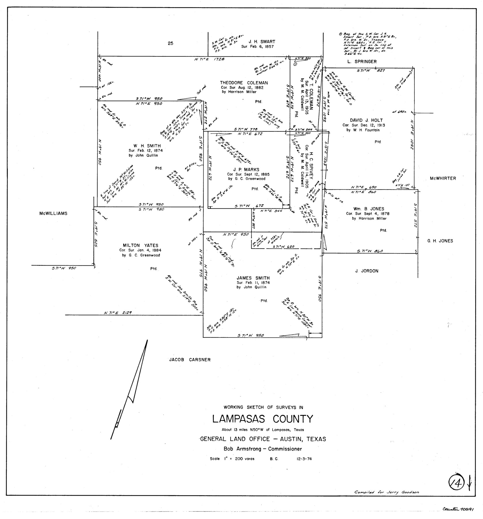
Lampasas County Working Sketch 14
-
Map/Doc
70291
-
Collection
General Map Collection
-
Object Dates
12/3/1974 (Creation Date)
-
People and Organizations
Beverly Christian (Draftsman)
-
Counties
Lampasas
-
Subjects
Surveying Working Sketch
-
Height x Width
23.4 x 21.8 inches
59.4 x 55.4 cm
-
Scale
1" = 200 varas
Part of: General Map Collection
Flight Mission No. BRA-7M, Frame 29, Jefferson County

Print $20.00
- Digital $50.00
Flight Mission No. BRA-7M, Frame 29, Jefferson County
1953
Size 18.5 x 22.3 inches
Map/Doc 85480
Nueces County Rolled Sketch 51A

Print $20.00
- Digital $50.00
Nueces County Rolled Sketch 51A
1978
Size 27.6 x 39.1 inches
Map/Doc 6890
Presidio County Sketch File 46

Print $8.00
- Digital $50.00
Presidio County Sketch File 46
1915
Size 10.2 x 8.3 inches
Map/Doc 34535
[St. Louis & Southwestern]
![64275, [St. Louis & Southwestern], General Map Collection](https://historictexasmaps.com/wmedia_w700/maps/64275.tif.jpg)
Print $20.00
- Digital $50.00
[St. Louis & Southwestern]
Size 20.8 x 28.6 inches
Map/Doc 64275

Taylor County Sketch File 6

Print $40.00
- Digital $50.00
Taylor County Sketch File 6
Size 40.1 x 55.0 inches
Map/Doc 10382
Milam County Working Sketch 16

Print $20.00
- Digital $50.00
Milam County Working Sketch 16
Size 30.4 x 36.2 inches
Map/Doc 71028
Outer Continental Shelf Leasing Maps (Texas Offshore Operations)

Print $20.00
- Digital $50.00
Outer Continental Shelf Leasing Maps (Texas Offshore Operations)
Size 17.3 x 16.7 inches
Map/Doc 75841
Presidio County Rolled Sketch 26

Print $20.00
- Digital $50.00
Presidio County Rolled Sketch 26
1886
Size 33.9 x 26.9 inches
Map/Doc 7333
Terrell County Rolled Sketch 43

Print $20.00
- Digital $50.00
Terrell County Rolled Sketch 43
1950
Size 27.5 x 36.4 inches
Map/Doc 7946
Goliad County Working Sketch 20

Print $20.00
- Digital $50.00
Goliad County Working Sketch 20
1955
Size 31.4 x 22.8 inches
Map/Doc 63210
Real County Rolled Sketch 18

Print $20.00
- Digital $50.00
Real County Rolled Sketch 18
Size 22.0 x 27.9 inches
Map/Doc 7460
You may also like
Flight Mission No. BRA-3M, Frame 127, Jefferson County

Print $20.00
- Digital $50.00
Flight Mission No. BRA-3M, Frame 127, Jefferson County
1953
Size 18.5 x 21.6 inches
Map/Doc 85401
Tyler County Working Sketch 4

Print $20.00
- Digital $50.00
Tyler County Working Sketch 4
1926
Size 19.4 x 35.8 inches
Map/Doc 69474
Upton County Working Sketch 57

Print $20.00
- Digital $50.00
Upton County Working Sketch 57
1988
Size 28.9 x 37.4 inches
Map/Doc 69554

Coryell County Sketch File 12

Print $20.00
- Digital $50.00
Coryell County Sketch File 12
1863
Size 21.7 x 19.3 inches
Map/Doc 11181
Wilbarger Co.

Print $40.00
- Digital $50.00
Wilbarger Co.
1907
Size 49.1 x 40.3 inches
Map/Doc 63126
[F. W. & D. C. Ry. Co. Alignment and Right of Way Map, Clay County]
![64740, [F. W. & D. C. Ry. Co. Alignment and Right of Way Map, Clay County], General Map Collection](https://historictexasmaps.com/wmedia_w700/maps/64740-GC.tif.jpg)
Print $20.00
- Digital $50.00
[F. W. & D. C. Ry. Co. Alignment and Right of Way Map, Clay County]
1927
Size 18.7 x 11.8 inches
Map/Doc 64740
Flight Mission No. DCL-6C, Frame 6, Kenedy County

Print $20.00
- Digital $50.00
Flight Mission No. DCL-6C, Frame 6, Kenedy County
1943
Size 18.6 x 22.3 inches
Map/Doc 85866

[Ft. W. & R. G. Ry. Right of Way Map, Chapin to Bluffdale, Hood County, Texas]
![64646, [Ft. W. & R. G. Ry. Right of Way Map, Chapin to Bluffdale, Hood County, Texas], General Map Collection](https://historictexasmaps.com/wmedia_w700/maps/64646.tif.jpg)
Print $40.00
- Digital $50.00
[Ft. W. & R. G. Ry. Right of Way Map, Chapin to Bluffdale, Hood County, Texas]
1918
Size 36.8 x 69.7 inches
Map/Doc 64646
Rio Grande, La Puerta Sheet

Print $20.00
- Digital $50.00
Rio Grande, La Puerta Sheet
1931
Size 29.7 x 43.4 inches
Map/Doc 65106
Aransas County Working Sketch Graphic Index

Print $20.00
- Digital $50.00
Aransas County Working Sketch Graphic Index
1947
Size 36.8 x 36.6 inches
Map/Doc 76455