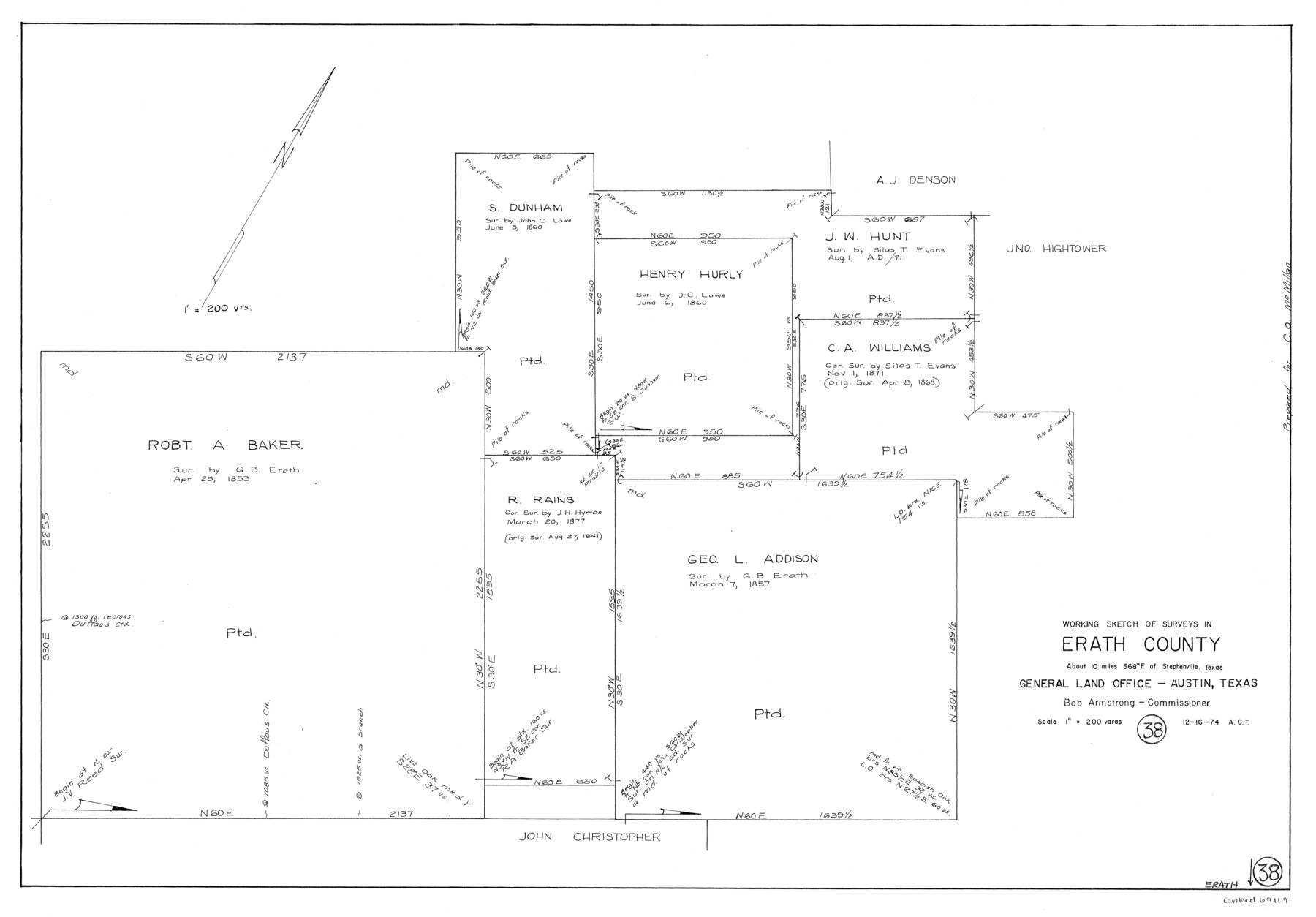
Erath County Working Sketch 38
-
Map/Doc
69119
-
Collection
General Map Collection
-
Object Dates
12/16/1974 (Creation Date)
-
People and Organizations
Abner G. Trigg (Draftsman)
-
Counties
Erath
-
Subjects
Surveying Working Sketch
-
Height x Width
22.1 x 31.7 inches
56.1 x 80.5 cm
-
Scale
1" = 200 varas
Part of: General Map Collection
Map of R. H. Welder Ranch, San Patricio County, Texas

Print $40.00
- Digital $50.00
Map of R. H. Welder Ranch, San Patricio County, Texas
1953
Size 30.0 x 61.4 inches
Map/Doc 61406
Flight Mission No. DQN-2K, Frame 147, Calhoun County

Print $20.00
- Digital $50.00
Flight Mission No. DQN-2K, Frame 147, Calhoun County
1953
Size 19.0 x 22.6 inches
Map/Doc 84316
Flight Mission No. BRA-16M, Frame 64, Jefferson County

Print $20.00
- Digital $50.00
Flight Mission No. BRA-16M, Frame 64, Jefferson County
1953
Size 18.8 x 22.3 inches
Map/Doc 85681
Flight Mission No. CGI-1N, Frame 167, Cameron County

Print $20.00
- Digital $50.00
Flight Mission No. CGI-1N, Frame 167, Cameron County
1955
Size 18.6 x 22.3 inches
Map/Doc 84502
Pecos County Sketch File 28

Print $20.00
- Digital $50.00
Pecos County Sketch File 28
1927
Size 23.4 x 21.6 inches
Map/Doc 12168
Nueces County Sketch File 54

Print $4.00
- Digital $50.00
Nueces County Sketch File 54
1856
Size 12.7 x 8.1 inches
Map/Doc 32865
Atascosa County Sketch File 41a

Print $10.00
- Digital $50.00
Atascosa County Sketch File 41a
1956
Size 9.3 x 7.4 inches
Map/Doc 13841
Carta Eclesiastica

Print $20.00
- Digital $50.00
Carta Eclesiastica
1897
Size 26.1 x 34.1 inches
Map/Doc 96799
DeWitt County

Print $40.00
- Digital $50.00
DeWitt County
1987
Size 41.4 x 49.9 inches
Map/Doc 77263
Texas showing Counties, Cities, Towns, Railroads and Water-courses. Completely indexed, showing locations with latest census population figures.

Print $20.00
- Digital $50.00
Texas showing Counties, Cities, Towns, Railroads and Water-courses. Completely indexed, showing locations with latest census population figures.
1950
Size 32.0 x 28.5 inches
Map/Doc 97097
Kaufman County Boundary File 3

Print $14.00
- Digital $50.00
Kaufman County Boundary File 3
Size 12.7 x 8.2 inches
Map/Doc 55922
Flight Mission No. DIX-8P, Frame 88, Aransas County

Print $20.00
- Digital $50.00
Flight Mission No. DIX-8P, Frame 88, Aransas County
1956
Size 18.6 x 22.3 inches
Map/Doc 83913
You may also like
Northeastern United States Including the Great Lakes Region

Northeastern United States Including the Great Lakes Region
1959
Size 25.6 x 19.3 inches
Map/Doc 92395
Working Sketch in Dimmit Co.

Print $20.00
- Digital $50.00
Working Sketch in Dimmit Co.
1883
Size 14.9 x 14.6 inches
Map/Doc 436
[I. M. Bolton, L. S. Thacker, and R. C. Poteet Subdivisions]
![92577, [I. M. Bolton, L. S. Thacker, and R. C. Poteet Subdivisions], Twichell Survey Records](https://historictexasmaps.com/wmedia_w700/maps/92577-1.tif.jpg)
Print $20.00
- Digital $50.00
[I. M. Bolton, L. S. Thacker, and R. C. Poteet Subdivisions]
1924
Size 18.8 x 24.5 inches
Map/Doc 92577
[Map of Resurvey of Block 34 and 35, Township 5 N]
![90551, [Map of Resurvey of Block 34 and 35, Township 5 N], Twichell Survey Records](https://historictexasmaps.com/wmedia_w700/maps/90551-1.tif.jpg)
Print $20.00
- Digital $50.00
[Map of Resurvey of Block 34 and 35, Township 5 N]
1915
Size 25.5 x 16.4 inches
Map/Doc 90551
Wheeler County

Print $20.00
- Digital $50.00
Wheeler County
1899
Size 44.2 x 38.7 inches
Map/Doc 63121
Calhoun County Rolled Sketch 30

Print $20.00
- Digital $50.00
Calhoun County Rolled Sketch 30
1974
Size 18.5 x 27.5 inches
Map/Doc 5496
Harris County Sketch File 69b

Print $20.00
- Digital $50.00
Harris County Sketch File 69b
1938
Size 25.3 x 18.9 inches
Map/Doc 11664
The Republic County of Refugio. December 29, 1845

Print $20.00
The Republic County of Refugio. December 29, 1845
2020
Size 22.3 x 21.6 inches
Map/Doc 96258
Hidalgo County Sketch File 14

Print $20.00
- Digital $50.00
Hidalgo County Sketch File 14
Size 29.6 x 24.5 inches
Map/Doc 11764
Pecos County Working Sketch 5

Print $20.00
- Digital $50.00
Pecos County Working Sketch 5
1886
Size 22.8 x 19.2 inches
Map/Doc 71475
[Sketch with field note calls of the boundaries of Webb, Duval, Jim Wells,Nueces, Kleberg, Zapata, Jim Hogg, Brooks, Willacy, Starr, Hidalgo and Cameron Counties]
![1689, [Sketch with field note calls of the boundaries of Webb, Duval, Jim Wells,Nueces, Kleberg, Zapata, Jim Hogg, Brooks, Willacy, Starr, Hidalgo and Cameron Counties], General Map Collection](https://historictexasmaps.com/wmedia_w700/pdf_converted_jpg/qi_pdf_thumbnail_720.jpg)
Print $20.00
- Digital $50.00
[Sketch with field note calls of the boundaries of Webb, Duval, Jim Wells,Nueces, Kleberg, Zapata, Jim Hogg, Brooks, Willacy, Starr, Hidalgo and Cameron Counties]
1915
Size 21.9 x 26.2 inches
Map/Doc 1689
Somervell County Working Sketch 3

Print $20.00
- Digital $50.00
Somervell County Working Sketch 3
1968
Size 23.0 x 30.4 inches
Map/Doc 63907