Pecos County Sketch File 28
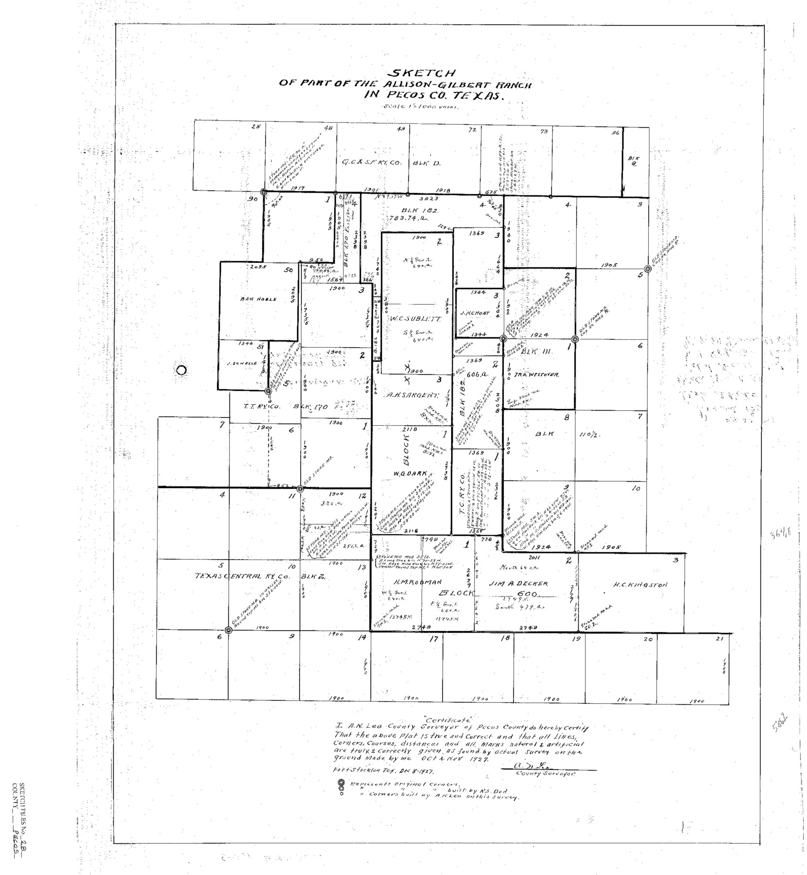
Sketch of Part of the Allison-Gilbert Ranch in Pecos County, Texas
-
Map/Doc
12168
-
Collection
General Map Collection
-
Object Dates
12/8/1927 (Creation Date)
12/17/1927 (File Date)
10/1927 (Survey Date)
11/1927 (Survey Date)
-
People and Organizations
A.N. Lea (Surveyor/Engineer)
-
Counties
Pecos
-
Subjects
Surveying Sketch File
-
Height x Width
23.4 x 21.6 inches
59.4 x 54.9 cm
-
Medium
paper, print
-
Scale
1" = 1000 varas
-
Features
Allison-Gilbert Ranch
Part of: General Map Collection
Shores of Nueces Bay, Texas

Print $40.00
- Digital $50.00
Shores of Nueces Bay, Texas
1882
Size 33.0 x 54.3 inches
Map/Doc 73464
Val Verde County Sketch File 50

Print $8.00
- Digital $50.00
Val Verde County Sketch File 50
1956
Size 11.5 x 8.9 inches
Map/Doc 39316
Travis County Sketch File 5

Print $4.00
- Digital $50.00
Travis County Sketch File 5
Size 11.0 x 8.2 inches
Map/Doc 38281
Map No. 1 - Rio Bravo del Norte section of boundary between the United States & Mexico agreed upon by the Joint Commission under the Treaty of Guadalupe Hidalgo

Print $20.00
- Digital $50.00
Map No. 1 - Rio Bravo del Norte section of boundary between the United States & Mexico agreed upon by the Joint Commission under the Treaty of Guadalupe Hidalgo
1852
Size 18.4 x 27.0 inches
Map/Doc 72864

Sutton County Working Sketch 43

Print $20.00
- Digital $50.00
Sutton County Working Sketch 43
1951
Size 23.1 x 22.1 inches
Map/Doc 62386
Briscoe County Rolled Sketch 14B

Print $20.00
- Digital $50.00
Briscoe County Rolled Sketch 14B
1929
Size 32.6 x 37.3 inches
Map/Doc 8531
Key to Photo Index Sheets of Texas Coast Portion

Print $20.00
- Digital $50.00
Key to Photo Index Sheets of Texas Coast Portion
1954
Size 20.0 x 24.0 inches
Map/Doc 83436
Maps of Gulf Intracoastal Waterway, Texas - Sabine River to the Rio Grande and connecting waterways including ship channels

Print $20.00
- Digital $50.00
Maps of Gulf Intracoastal Waterway, Texas - Sabine River to the Rio Grande and connecting waterways including ship channels
1966
Size 14.5 x 22.2 inches
Map/Doc 61960
Ector County Working Sketch 1

Print $20.00
- Digital $50.00
Ector County Working Sketch 1
1930
Size 40.7 x 17.0 inches
Map/Doc 62182
Crockett County Working Sketch 21

Print $20.00
- Digital $50.00
Crockett County Working Sketch 21
1920
Size 18.5 x 24.8 inches
Map/Doc 68354
Fractional Township No. 7 South Range No. 15 East of the Indian Meridian, Indian Territory

Print $20.00
- Digital $50.00
Fractional Township No. 7 South Range No. 15 East of the Indian Meridian, Indian Territory
1896
Size 19.2 x 24.3 inches
Map/Doc 75226
You may also like
Pecos County Sketch File 54

Print $20.00
- Digital $50.00
Pecos County Sketch File 54
Size 14.5 x 22.4 inches
Map/Doc 12180
Nueces County NRC Article 33.136 Sketch 4

Print $50.00
- Digital $50.00
Nueces County NRC Article 33.136 Sketch 4
2001
Size 17.7 x 24.1 inches
Map/Doc 7167
Henderson County Working Sketch 20

Print $20.00
- Digital $50.00
Henderson County Working Sketch 20
1947
Size 31.6 x 18.9 inches
Map/Doc 66153
[Surveys along the Liberty and Hardin County line]
![295, [Surveys along the Liberty and Hardin County line], General Map Collection](https://historictexasmaps.com/wmedia_w700/maps/295.tif.jpg)
Print $2.00
- Digital $50.00
[Surveys along the Liberty and Hardin County line]
1847
Size 13.5 x 7.7 inches
Map/Doc 295
Harris County Sketch File 11

Print $18.00
- Digital $50.00
Harris County Sketch File 11
1895
Size 11.3 x 8.8 inches
Map/Doc 25342
[Blocks 16, O, N, B19 and 34]
![91958, [Blocks 16, O, N, B19 and 34], Twichell Survey Records](https://historictexasmaps.com/wmedia_w700/maps/91958-1.tif.jpg)
Print $20.00
- Digital $50.00
[Blocks 16, O, N, B19 and 34]
Size 22.5 x 26.1 inches
Map/Doc 91958

Yoakum County Sketch File 10

Print $20.00
- Digital $50.00
Yoakum County Sketch File 10
1902
Size 33.7 x 18.8 inches
Map/Doc 12706
Cochran County Working Sketch 5

Print $20.00
- Digital $50.00
Cochran County Working Sketch 5
Size 23.8 x 24.9 inches
Map/Doc 68016
Crockett County Working Sketch 20

Print $20.00
- Digital $50.00
Crockett County Working Sketch 20
1920
Size 43.7 x 27.6 inches
Map/Doc 68353
Gaines County Working Sketch 1

Print $40.00
- Digital $50.00
Gaines County Working Sketch 1
1937
Size 22.7 x 53.1 inches
Map/Doc 69301
Shelby County Sketch File 21

Print $2.00
- Digital $50.00
Shelby County Sketch File 21
Size 8.9 x 4.0 inches
Map/Doc 36642