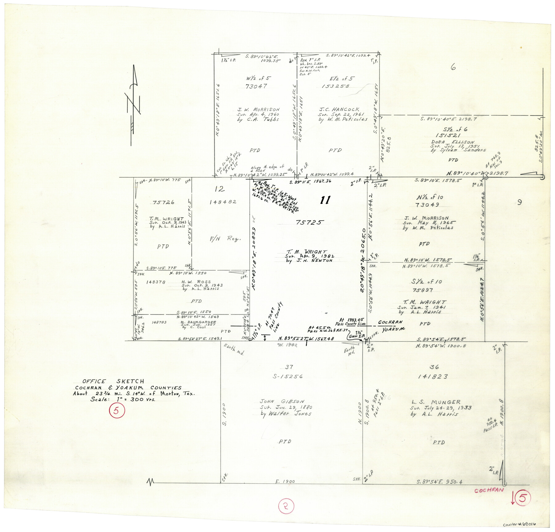
Cochran County Working Sketch 5
-
Map/Doc
68016
-
Collection
General Map Collection
-
Counties
Cochran Yoakum
-
Subjects
Surveying Working Sketch
-
Height x Width
23.8 x 24.9 inches
60.5 x 63.3 cm
-
Scale
1" = 300 varas
Part of: General Map Collection
Wise County Working Sketch 17

Print $20.00
- Digital $50.00
Wise County Working Sketch 17
1972
Size 29.9 x 25.0 inches
Map/Doc 72631
Webb County Sketch File 15-1

Print $20.00
- Digital $50.00
Webb County Sketch File 15-1
1935
Size 35.0 x 25.2 inches
Map/Doc 12634
Goliad County Sketch File 42

Print $8.00
- Digital $50.00
Goliad County Sketch File 42
1847
Size 13.0 x 8.2 inches
Map/Doc 24349
Limestone County Working Sketch Graphic Index

Print $20.00
- Digital $50.00
Limestone County Working Sketch Graphic Index
1971
Size 47.8 x 32.9 inches
Map/Doc 76621
Permanent Lakes and Marshes in Calhoun, Victoria and Jackson Cos. for Mineral Development

Print $20.00
- Digital $50.00
Permanent Lakes and Marshes in Calhoun, Victoria and Jackson Cos. for Mineral Development
1937
Size 36.9 x 38.9 inches
Map/Doc 2973
Val Verde County Working Sketch 7

Print $20.00
- Digital $50.00
Val Verde County Working Sketch 7
1915
Size 21.9 x 19.5 inches
Map/Doc 72142
Presidio County Sketch File 58a

Print $14.00
- Digital $50.00
Presidio County Sketch File 58a
1980
Size 11.2 x 8.8 inches
Map/Doc 34628
Knox County Rolled Sketch 10

Print $40.00
- Digital $50.00
Knox County Rolled Sketch 10
Size 56.6 x 35.6 inches
Map/Doc 10718
Duval County Rolled Sketch 23

Print $20.00
- Digital $50.00
Duval County Rolled Sketch 23
1943
Size 23.0 x 20.9 inches
Map/Doc 5742
Map of Liberty County

Print $40.00
- Digital $50.00
Map of Liberty County
1841
Size 60.1 x 37.3 inches
Map/Doc 1951
[Surveys along the San Jacinto River]
![62, [Surveys along the San Jacinto River], General Map Collection](https://historictexasmaps.com/wmedia_w700/maps/62.tif.jpg)
Print $3.00
- Digital $50.00
[Surveys along the San Jacinto River]
1841
Size 10.7 x 14.5 inches
Map/Doc 62
Shackelford County Sketch File 13

Print $22.00
- Digital $50.00
Shackelford County Sketch File 13
1875
Size 12.8 x 15.8 inches
Map/Doc 36583
You may also like
Current Miscellaneous File 36

Print $12.00
- Digital $50.00
Current Miscellaneous File 36
Size 10.3 x 12.4 inches
Map/Doc 73952
Crockett County Sketch File 58a

Print $20.00
- Digital $50.00
Crockett County Sketch File 58a
1923
Size 21.1 x 25.8 inches
Map/Doc 5601
A new & correct map of Texas compiled from the most recent surveys & authorities to the year 1845

Print $20.00
- Digital $50.00
A new & correct map of Texas compiled from the most recent surveys & authorities to the year 1845
1845
Size 22.4 x 28.5 inches
Map/Doc 96973
Galveston County Working Sketch 12

Print $20.00
- Digital $50.00
Galveston County Working Sketch 12
1967
Size 14.8 x 22.4 inches
Map/Doc 69349
Harris County Working Sketch 47

Print $40.00
- Digital $50.00
Harris County Working Sketch 47
1942
Size 39.5 x 51.9 inches
Map/Doc 65939
[Capitol Lands, Block B6]
![91402, [Capitol Lands, Block B6], Twichell Survey Records](https://historictexasmaps.com/wmedia_w700/maps/91402-1.tif.jpg)
Print $20.00
- Digital $50.00
[Capitol Lands, Block B6]
Size 22.7 x 27.4 inches
Map/Doc 91402
Childress County Rolled Sketch 8

Print $20.00
- Digital $50.00
Childress County Rolled Sketch 8
1889
Size 12.4 x 22.2 inches
Map/Doc 5442
Plano de la Sauteña. Indicando los terrenos irrigados en Texas

Plano de la Sauteña. Indicando los terrenos irrigados en Texas
Size 38.6 x 37.8 inches
Map/Doc 94566
Current Miscellaneous File 64

Print $12.00
- Digital $50.00
Current Miscellaneous File 64
1954
Size 10.8 x 8.5 inches
Map/Doc 74103
Stephens County Working Sketch 23

Print $20.00
- Digital $50.00
Stephens County Working Sketch 23
1975
Size 31.0 x 38.8 inches
Map/Doc 63966
The Republic County of Houston. Spring 1842

Print $20.00
The Republic County of Houston. Spring 1842
2020
Size 19.7 x 21.8 inches
Map/Doc 96182
Liberty County Sketch File 40

Print $3.00
- Digital $50.00
Liberty County Sketch File 40
Size 9.8 x 17.3 inches
Map/Doc 29996