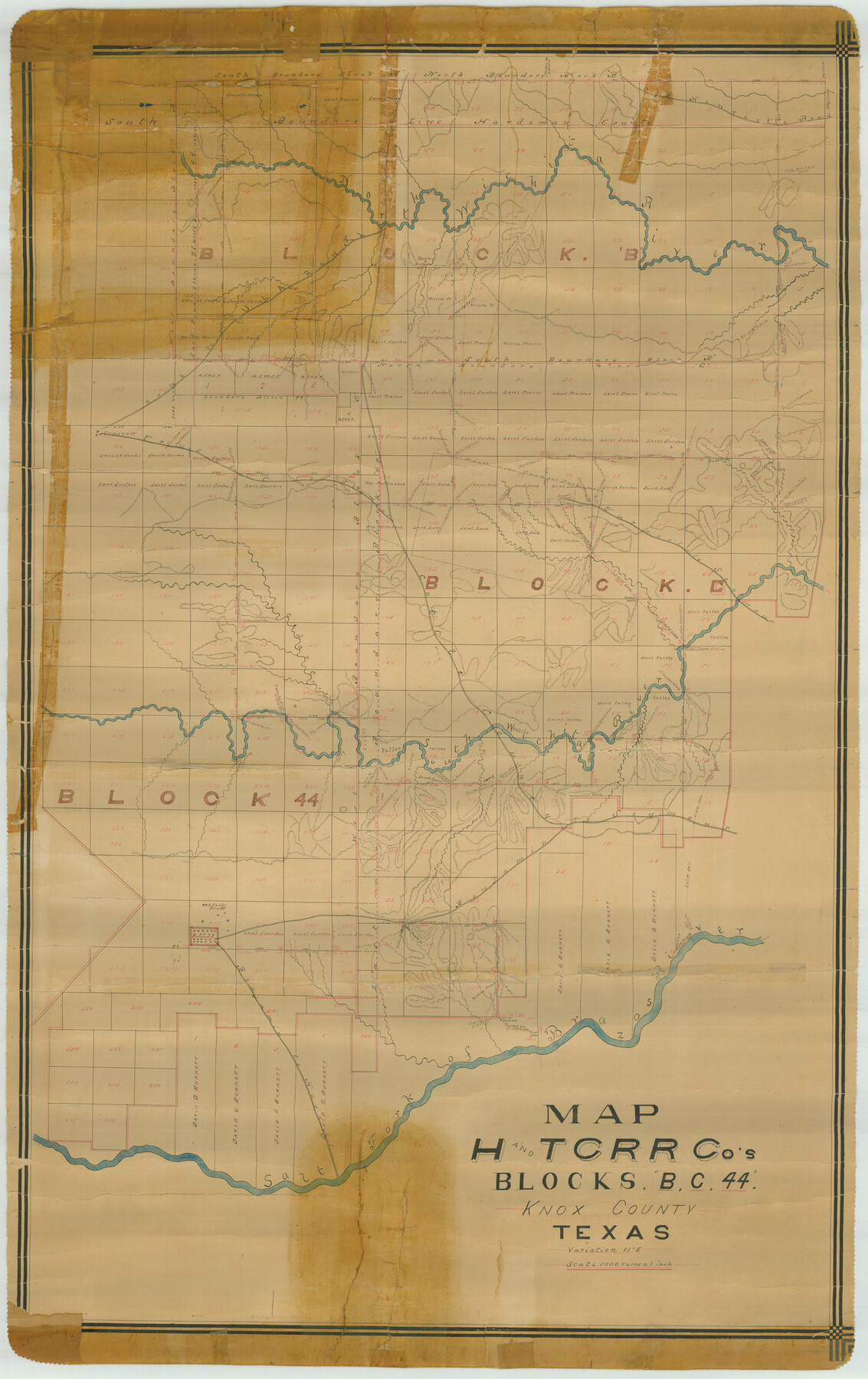
Knox County Rolled Sketch 10
Map H. & T. C. R.R. Co's Blocks B, C, 44, Knox County, Texas
-
Map/Doc
10718
-
Collection
General Map Collection
-
Counties
Knox
-
Subjects
Surveying Rolled Sketch
-
Height x Width
56.6 x 35.6 inches
143.8 x 90.4 cm
-
Medium
paper, manuscript
-
Scale
1" = 1000 varas
Part of: General Map Collection
Chambers County Sketch File 41

Print $32.00
- Digital $50.00
Chambers County Sketch File 41
Size 14.7 x 9.1 inches
Map/Doc 17694
Newton County Sketch File 20

Print $4.00
- Digital $50.00
Newton County Sketch File 20
1893
Size 14.2 x 8.7 inches
Map/Doc 32395
Township No. 7 South Range No. 4 West of the Indian Meridian, Chickasaw Lands

Print $4.00
- Digital $50.00
Township No. 7 South Range No. 4 West of the Indian Meridian, Chickasaw Lands
1871
Size 18.2 x 22.4 inches
Map/Doc 75146
Flight Mission No. CRK-3P, Frame 174, Refugio County

Print $20.00
- Digital $50.00
Flight Mission No. CRK-3P, Frame 174, Refugio County
1956
Size 18.6 x 22.3 inches
Map/Doc 86921
[University Lands in West Texas]
![2422, [University Lands in West Texas], General Map Collection](https://historictexasmaps.com/wmedia_w700/maps/2422.tif.jpg)
Print $20.00
- Digital $50.00
[University Lands in West Texas]
1938
Size 20.3 x 28.1 inches
Map/Doc 2422
Aransas County Rolled Sketch 5

Print $53.00
- Digital $50.00
Aransas County Rolled Sketch 5
1953
Size 10.5 x 15.4 inches
Map/Doc 42075
Trinity County Working Sketch 7b

Print $20.00
- Digital $50.00
Trinity County Working Sketch 7b
1939
Size 27.4 x 24.7 inches
Map/Doc 69456
Flight Mission No. CUG-1P, Frame 159, Kleberg County

Print $20.00
- Digital $50.00
Flight Mission No. CUG-1P, Frame 159, Kleberg County
1956
Size 18.5 x 22.3 inches
Map/Doc 86166
Upton County Rolled Sketch 26

Print $20.00
- Digital $50.00
Upton County Rolled Sketch 26
1942
Size 35.7 x 37.2 inches
Map/Doc 10045
Cochran County Sketch File 8

Print $32.00
- Digital $50.00
Cochran County Sketch File 8
1940
Size 11.0 x 8.8 inches
Map/Doc 18555
Fannin County Working Sketch 10

Print $20.00
- Digital $50.00
Fannin County Working Sketch 10
1989
Size 26.5 x 38.0 inches
Map/Doc 69164
Shelby County Working Sketch 27

Print $20.00
- Digital $50.00
Shelby County Working Sketch 27
1995
Size 32.8 x 39.9 inches
Map/Doc 63881
You may also like
Pecos County Sketch File 105

Print $4.00
- Digital $50.00
Pecos County Sketch File 105
1965
Size 14.3 x 8.8 inches
Map/Doc 34028
[Pecos and Northern Texas Ry., Bailey Co., from Parmer Co. line through Lariat and Muleshoe to Lamb Co. line]
![64635, [Pecos and Northern Texas Ry., Bailey Co., from Parmer Co. line through Lariat and Muleshoe to Lamb Co. line], General Map Collection](https://historictexasmaps.com/wmedia_w700/maps/64635.tif.jpg)
Print $40.00
- Digital $50.00
[Pecos and Northern Texas Ry., Bailey Co., from Parmer Co. line through Lariat and Muleshoe to Lamb Co. line]
1912
Size 19.5 x 121.6 inches
Map/Doc 64635
[Town lots on Galveston Island]
![11, [Town lots on Galveston Island], General Map Collection](https://historictexasmaps.com/wmedia_w700/maps/11.tif.jpg)
Print $20.00
- Digital $50.00
[Town lots on Galveston Island]
1839
Size 18.8 x 23.0 inches
Map/Doc 11
[Sketch for Mineral Application 26501 - Sabine River, T. A. Oldhausen]
![2841, [Sketch for Mineral Application 26501 - Sabine River, T. A. Oldhausen], General Map Collection](https://historictexasmaps.com/wmedia_w700/maps/2841.tif.jpg)
Print $20.00
- Digital $50.00
[Sketch for Mineral Application 26501 - Sabine River, T. A. Oldhausen]
1931
Size 24.4 x 36.8 inches
Map/Doc 2841
Karnes County Boundary File 2a

Print $4.00
- Digital $50.00
Karnes County Boundary File 2a
Size 12.7 x 8.1 inches
Map/Doc 55692
Live Oak County Rolled Sketch 10

Print $20.00
- Digital $50.00
Live Oak County Rolled Sketch 10
1983
Size 38.4 x 43.9 inches
Map/Doc 9456
[Jose Antonio Sepulveda grant]
![349, [Jose Antonio Sepulveda grant], General Map Collection](https://historictexasmaps.com/wmedia_w700/maps/349.tif.jpg)
Print $2.00
- Digital $50.00
[Jose Antonio Sepulveda grant]
Size 5.9 x 5.7 inches
Map/Doc 349
Cottle County Working Sketch 19

Print $20.00
- Digital $50.00
Cottle County Working Sketch 19
1978
Size 33.2 x 29.3 inches
Map/Doc 68329
Real County Working Sketch Graphic Index, Sheet 1 (Sketches 1 to 42)

Print $20.00
- Digital $50.00
Real County Working Sketch Graphic Index, Sheet 1 (Sketches 1 to 42)
1972
Size 42.9 x 31.0 inches
Map/Doc 76678

Kendall County Working Sketch 29

Print $20.00
- Digital $50.00
Kendall County Working Sketch 29
2025
Map/Doc 97408
Flight Mission No. DQN-2K, Frame 165, Calhoun County

Print $20.00
- Digital $50.00
Flight Mission No. DQN-2K, Frame 165, Calhoun County
1953
Size 18.5 x 22.3 inches
Map/Doc 84327