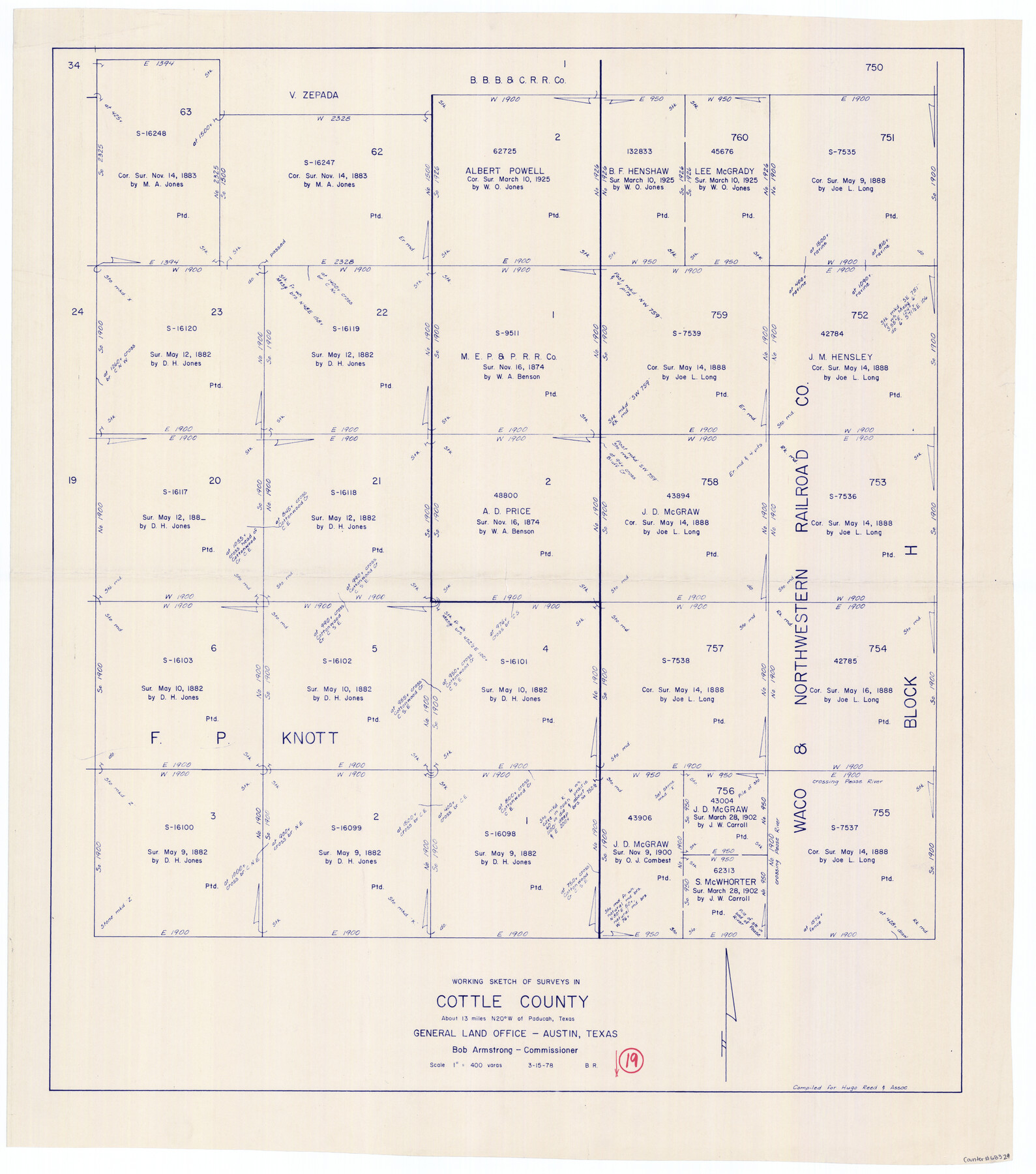
Cottle County Working Sketch 19
-
Map/Doc
68329
-
Collection
General Map Collection
-
Object Dates
3/15/1978 (Creation Date)
-
People and Organizations
Beverly Robison (Draftsman)
-
Counties
Cottle
-
Subjects
Surveying Working Sketch
-
Height x Width
33.2 x 29.3 inches
84.3 x 74.4 cm
-
Scale
1" = 400 varas
Part of: General Map Collection
Central Part of Jeff Davis Co.

Print $40.00
- Digital $50.00
Central Part of Jeff Davis Co.
1982
Size 54.2 x 41.6 inches
Map/Doc 77326
Glasscock County Rolled Sketch 15

Print $20.00
- Digital $50.00
Glasscock County Rolled Sketch 15
1964
Size 36.5 x 35.8 inches
Map/Doc 9059
Brown County Working Sketch 1

Print $20.00
- Digital $50.00
Brown County Working Sketch 1
1918
Size 20.3 x 29.0 inches
Map/Doc 67766
Grayson County Sketch File 12

Print $4.00
- Digital $50.00
Grayson County Sketch File 12
1853
Size 12.8 x 8.4 inches
Map/Doc 24478
Duval County Working Sketch 53

Print $20.00
- Digital $50.00
Duval County Working Sketch 53
1948
Size 34.7 x 37.5 inches
Map/Doc 68777
[Sketch for Mineral Application 16700 - Pecos River Bed]
![2809, [Sketch for Mineral Application 16700 - Pecos River Bed], General Map Collection](https://historictexasmaps.com/wmedia_w700/maps/2809.tif.jpg)
Print $20.00
- Digital $50.00
[Sketch for Mineral Application 16700 - Pecos River Bed]
1927
Size 14.8 x 30.8 inches
Map/Doc 2809
Texas Intracoastal Waterway - Laguna Madre - Rincon de San Jose to Chubby Island

Print $20.00
- Digital $50.00
Texas Intracoastal Waterway - Laguna Madre - Rincon de San Jose to Chubby Island
1957
Size 38.9 x 27.3 inches
Map/Doc 73513
Flight Mission No. BRA-8M, Frame 146, Jefferson County

Print $20.00
- Digital $50.00
Flight Mission No. BRA-8M, Frame 146, Jefferson County
1953
Size 16.0 x 16.1 inches
Map/Doc 85638
Flight Mission No. DAG-24K, Frame 45, Matagorda County

Print $20.00
- Digital $50.00
Flight Mission No. DAG-24K, Frame 45, Matagorda County
1953
Size 18.6 x 22.2 inches
Map/Doc 86532
Carson County Working Sketch 3

Print $20.00
- Digital $50.00
Carson County Working Sketch 3
1922
Size 18.3 x 26.3 inches
Map/Doc 67874
Hardeman County Sketch File 16

Print $20.00
- Digital $50.00
Hardeman County Sketch File 16
Size 21.9 x 26.8 inches
Map/Doc 11628
Wharton County Sketch File 3a

Print $4.00
- Digital $50.00
Wharton County Sketch File 3a
1875
Size 6.8 x 4.6 inches
Map/Doc 39917
You may also like

Presidio County Rolled Sketch 3A

Print $20.00
- Digital $50.00
Presidio County Rolled Sketch 3A
Size 18.5 x 16.8 inches
Map/Doc 7327
Karnes County Boundary File 4

Print $14.00
- Digital $50.00
Karnes County Boundary File 4
Size 12.7 x 8.2 inches
Map/Doc 55698
Val Verde County Working Sketch 108

Print $20.00
- Digital $50.00
Val Verde County Working Sketch 108
1988
Size 31.1 x 41.3 inches
Map/Doc 72243
Crockett County Working Sketch 41

Print $20.00
- Digital $50.00
Crockett County Working Sketch 41
1928
Size 20.4 x 23.2 inches
Map/Doc 68374
Marion County Working Sketch 46

Print $20.00
- Digital $50.00
Marion County Working Sketch 46
2011
Size 21.4 x 29.1 inches
Map/Doc 90032
Flight Mission No. DQN-6K, Frame 88, Calhoun County

Print $20.00
- Digital $50.00
Flight Mission No. DQN-6K, Frame 88, Calhoun County
1953
Size 18.7 x 22.3 inches
Map/Doc 84448
[Surveys in Bexar County]
![93, [Surveys in Bexar County], General Map Collection](https://historictexasmaps.com/wmedia_w700/maps/93.tif.jpg)
Print $2.00
- Digital $50.00
[Surveys in Bexar County]
Size 11.3 x 6.9 inches
Map/Doc 93
Tarrant County

Print $20.00
- Digital $50.00
Tarrant County
1942
Size 46.5 x 37.1 inches
Map/Doc 77431
Calhoun County Rolled Sketch 12

Print $40.00
- Digital $50.00
Calhoun County Rolled Sketch 12
1940
Size 37.9 x 54.6 inches
Map/Doc 66845
General Highway Map, Blanco County, Texas

Print $20.00
General Highway Map, Blanco County, Texas
1961
Size 25.0 x 18.2 inches
Map/Doc 79376
