Texas Intracoastal Waterway - Laguna Madre - Rincon de San Jose to Chubby Island
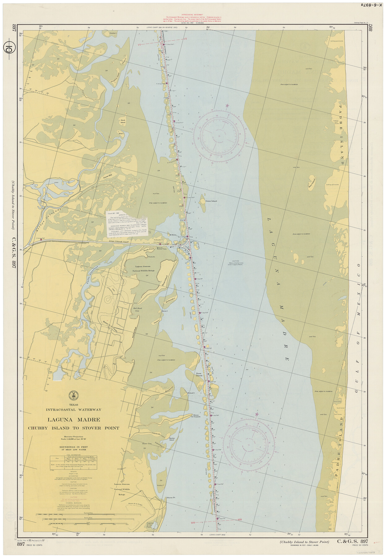
Texas Intracoastal Waterway - Laguna Madre - Chubby Island to Stover Point
K-6-896a; K-6-897a
-
Map/Doc
73513
-
Collection
General Map Collection
-
Object Dates
2/11/1957 (Creation Date)
-
Counties
Willacy Cameron
-
Subjects
Nautical Charts
-
Height x Width
38.9 x 27.3 inches
98.8 x 69.3 cm
Part of: General Map Collection
Red River County Working Sketch 23

Print $20.00
- Digital $50.00
Red River County Working Sketch 23
1958
Size 30.7 x 26.1 inches
Map/Doc 72006
Southern Part of Laguna Madre

Print $20.00
- Digital $50.00
Southern Part of Laguna Madre
1966
Size 44.2 x 34.8 inches
Map/Doc 73539

[William Steele Survey near Copano Bay]
![60284, [William Steele Survey near Copano Bay], General Map Collection](https://historictexasmaps.com/wmedia_w700/maps/60284-1.tif.jpg)
Print $3.00
- Digital $50.00
[William Steele Survey near Copano Bay]
1927
Size 15.5 x 9.5 inches
Map/Doc 60284
Llano County Working Sketch Graphic Index

Print $20.00
- Digital $50.00
Llano County Working Sketch Graphic Index
1943
Size 43.7 x 42.6 inches
Map/Doc 76624
Flight Mission No. CRC-4R, Frame 71, Chambers County

Print $20.00
- Digital $50.00
Flight Mission No. CRC-4R, Frame 71, Chambers County
1956
Size 18.7 x 22.5 inches
Map/Doc 84875
Carte Reduite du Golphe du Mexique et des isles de l'Amerique dressée au depost des cartes et plans de la Marine pour le service des vaisseaux du Roy

Print $20.00
- Digital $50.00
Carte Reduite du Golphe du Mexique et des isles de l'Amerique dressée au depost des cartes et plans de la Marine pour le service des vaisseaux du Roy
1774
Size 25.5 x 32.9 inches
Map/Doc 94097
Blanco County Sketch File 50

Print $6.00
- Digital $50.00
Blanco County Sketch File 50
1995
Size 11.5 x 8.8 inches
Map/Doc 14695
Wood County Working Sketch 16

Print $20.00
- Digital $50.00
Wood County Working Sketch 16
1987
Size 21.7 x 17.7 inches
Map/Doc 62016
Blanco County Working Sketch 8

Print $20.00
- Digital $50.00
Blanco County Working Sketch 8
1925
Size 23.0 x 22.3 inches
Map/Doc 67368
Menard County Boundary File 13

Print $32.00
- Digital $50.00
Menard County Boundary File 13
Size 8.9 x 9.4 inches
Map/Doc 57121
Hemphill County Sketch File 3

Print $8.00
- Digital $50.00
Hemphill County Sketch File 3
Size 11.4 x 6.5 inches
Map/Doc 26285
You may also like
Roberts County Sketch File 10

Print $32.00
- Digital $50.00
Roberts County Sketch File 10
2016
Size 11.0 x 8.5 inches
Map/Doc 94070
Flight Mission No. DIX-8P, Frame 88, Aransas County

Print $20.00
- Digital $50.00
Flight Mission No. DIX-8P, Frame 88, Aransas County
1956
Size 18.6 x 22.3 inches
Map/Doc 83913
Burleson County Working Sketch 12

Print $20.00
- Digital $50.00
Burleson County Working Sketch 12
1980
Size 20.6 x 12.0 inches
Map/Doc 67731
Hutchinson County Rolled Sketch 44-5

Print $20.00
- Digital $50.00
Hutchinson County Rolled Sketch 44-5
2002
Size 24.0 x 36.0 inches
Map/Doc 77541
Dallam County

Print $20.00
- Digital $50.00
Dallam County
1901
Size 43.8 x 29.3 inches
Map/Doc 93458
Webb County Rolled Sketch 5

Print $20.00
- Digital $50.00
Webb County Rolled Sketch 5
Size 43.2 x 23.0 inches
Map/Doc 8172
Denton County Working Sketch 11

Print $20.00
- Digital $50.00
Denton County Working Sketch 11
1960
Size 26.2 x 20.4 inches
Map/Doc 68616
Medina County, Texas

Print $20.00
- Digital $50.00
Medina County, Texas
1879
Size 31.8 x 26.4 inches
Map/Doc 579
Val Verde County Rolled Sketch 75

Print $20.00
- Digital $50.00
Val Verde County Rolled Sketch 75
1972
Size 28.9 x 40.6 inches
Map/Doc 8138
Prison Property, Walker Co.

Print $20.00
- Digital $50.00
Prison Property, Walker Co.
Size 24.4 x 23.5 inches
Map/Doc 62976
Crockett County Sketch File 42

Print $28.00
- Digital $50.00
Crockett County Sketch File 42
Size 12.8 x 8.4 inches
Map/Doc 19755