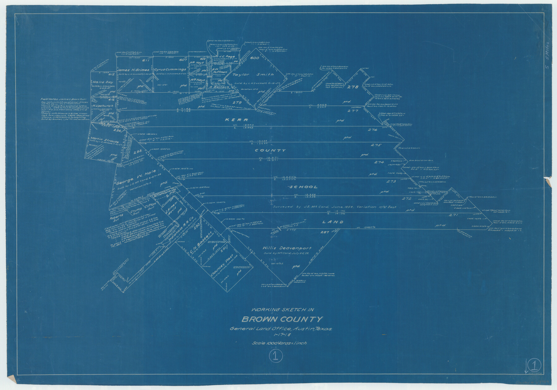
Brown County Working Sketch 1
- 
                          Map/Doc67766
- 
                            CollectionGeneral Map Collection
- 
                            Object Dates1/17/1918 (Creation Date)
- 
                            People and OrganizationsG.T. Wicker (Draftsman)
- 
                            CountiesBrown
- 
                            SubjectsSurveying Working Sketch
- 
                            Height x Width20.3 x 29.0 inches51.6 x 73.7 cm
- 
                            Scale1" = 1000 varas
Part of: General Map Collection
            Carte du Texas par M. Maris


                                            Print $20.00                    
                                             -                         Digital $50.00                                    
                Carte du Texas par M. Maris
1846
Size 19.3 x 17.2 inches
                                Map/Doc 2119
            
            Howard County Sketch File 6


                                            Print $44.00                    
                                             -                         Digital $50.00                                    
                Howard County Sketch File 6
1929
Size 18.6 x 14.4 inches
                                Map/Doc 26861
            
            Pecos County Working Sketch 63


                                            Print $20.00                    
                                             -                         Digital $50.00                                    
                Pecos County Working Sketch 63
1954
Size 29.5 x 33.2 inches
                                Map/Doc 71535
            
            Trinity River, Levee Improvement Districts, Widths of Floodways


                                            Print $20.00                    
                                             -                         Digital $50.00                                    
                Trinity River, Levee Improvement Districts, Widths of Floodways
1920
Size 31.8 x 23.2 inches
                                Map/Doc 65254
            
            Map of Kerr County


                                            Print $40.00                    
                                             -                         Digital $50.00                                    
                Map of Kerr County
1895
Size 41.3 x 57.1 inches
                                Map/Doc 7824
            
            Washington County


                                            Print $20.00                    
                                             -                         Digital $50.00                                    
                Washington County
1863
Size 15.9 x 27.2 inches
                                Map/Doc 4127
            
            Flight Mission No. CRC-6R, Frame 36, Chambers County


                                            Print $20.00                    
                                             -                         Digital $50.00                                    
                Flight Mission No. CRC-6R, Frame 36, Chambers County
1956
Size 18.8 x 22.4 inches
                                Map/Doc 84969
            
            Rio Grande Rectification Project, El Paso and Juarez Valley


                                            Print $20.00                    
                                             -                         Digital $50.00                                    
                Rio Grande Rectification Project, El Paso and Juarez Valley
1935
Size 10.7 x 29.7 inches
                                Map/Doc 60863
            
            [Gulf, Colorado & Santa Fe Railway Company]
            
                                    ![64411, [Gulf, Colorado & Santa Fe Railway Company], General Map Collection](https://historictexasmaps.com/wmedia_w700/maps/64411.tif.jpg) 


    ![64411, [Gulf, Colorado & Santa Fe Railway Company], General Map Collection](https://historictexasmaps.com/wmedia_w700/maps/64411.tif.jpg) 
                                
            
                                            Print $20.00                    
                                             -                         Digital $50.00                                    
                [Gulf, Colorado & Santa Fe Railway Company]
1893
Size 20.1 x 41.5 inches
                                Map/Doc 64411
            
            Maps of Gulf Intracoastal Waterway, Texas - Sabine River to the Rio Grande and connecting waterways including ship channels


                                            Print $20.00                    
                                             -                         Digital $50.00                                    
                Maps of Gulf Intracoastal Waterway, Texas - Sabine River to the Rio Grande and connecting waterways including ship channels
1966
Size 14.6 x 22.3 inches
                                Map/Doc 61934
            
            Cottle County


                                            Print $20.00                    
                                             -                         Digital $50.00                                    
                Cottle County
1971
Size 42.5 x 35.7 inches
                                Map/Doc 73118
            
            Sabine County Sketch File 6a


                                            Print $4.00                    
                                    
                Sabine County Sketch File 6a
1878
Size 8.1 x 12.5 inches
                                Map/Doc 35615
            You may also like
            Plat showing Deed Locations in East Half Section 2, Block E


                                            Print $20.00                    
                                             -                         Digital $50.00                                    
                Plat showing Deed Locations in East Half Section 2, Block E
Size 16.2 x 30.1 inches
                                Map/Doc 92736
            
            Bryant's Railroad Guide, the Tourists' and Emigrants' Hand-book of Travel


                                            Print $260.00                    
                                             -                         Digital $50.00                                    
                Bryant's Railroad Guide, the Tourists' and Emigrants' Hand-book of Travel
1875
Size 9.3 x 6.0 inches
                                Map/Doc 93627
            
            Dickens County


                                            Print $20.00                    
                                             -                         Digital $50.00                                    
                Dickens County
1895
Size 22.8 x 18.7 inches
                                Map/Doc 3484
            
            Working Sketch Crosby, Garza, Lynn, and Lubbock Counties


                                            Print $20.00                    
                                             -                         Digital $50.00                                    
                Working Sketch Crosby, Garza, Lynn, and Lubbock Counties
1904
Size 34.3 x 36.4 inches
                                Map/Doc 92695
            
            Flight Mission No. BRA-7M, Frame 116, Jefferson County


                                            Print $20.00                    
                                             -                         Digital $50.00                                    
                Flight Mission No. BRA-7M, Frame 116, Jefferson County
1953
Size 18.6 x 22.5 inches
                                Map/Doc 85510
            
            Garza County Sketch File 11


                                            Print $4.00                    
                                             -                         Digital $50.00                                    
                Garza County Sketch File 11
1901
Size 11.3 x 8.8 inches
                                Map/Doc 24066
            
            Stonewall County Working Sketch 31


                                            Print $20.00                    
                                             -                         Digital $50.00                                    
                Stonewall County Working Sketch 31
1983
Size 42.6 x 42.9 inches
                                Map/Doc 62338
            
            Duval County Rolled Sketch 29


                                            Print $20.00                    
                                             -                         Digital $50.00                                    
                Duval County Rolled Sketch 29
1947
Size 16.2 x 25.8 inches
                                Map/Doc 5746
            
            Hutchinson County Sketch File 32


                                            Print $20.00                    
                                             -                         Digital $50.00                                    
                Hutchinson County Sketch File 32
1924
Size 16.7 x 18.0 inches
                                Map/Doc 11820
            
            Edwards County Working Sketch 21


                                            Print $20.00                    
                                             -                         Digital $50.00                                    
                Edwards County Working Sketch 21
1935
Size 26.7 x 32.0 inches
                                Map/Doc 68897
             
                         
                                