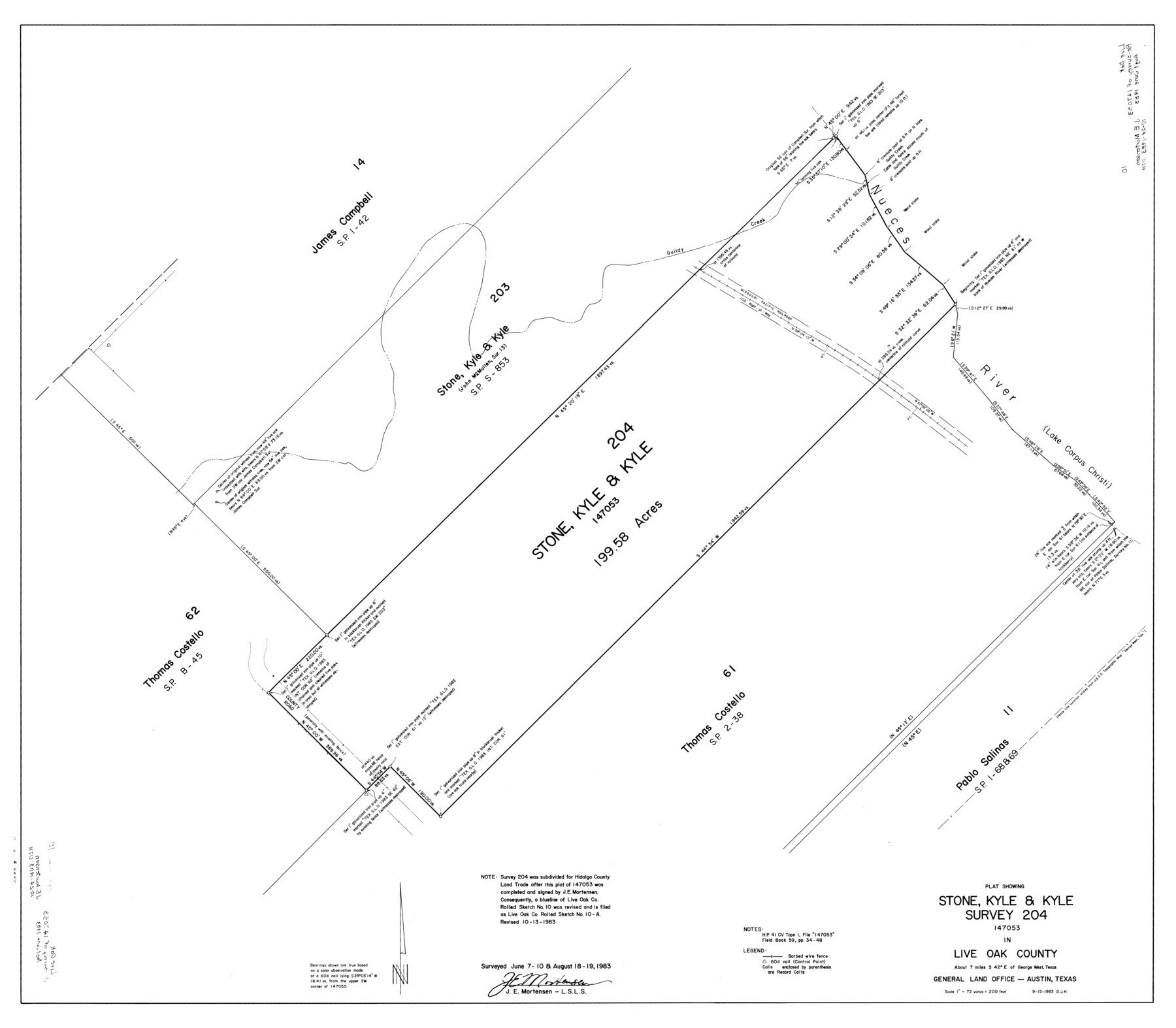
Live Oak County Rolled Sketch 10
Plat showing Stone, Kyle & Kyle survey 204 - 147053 in Live Oak County
-
Map/Doc
9456
-
Collection
General Map Collection
-
Object Dates
1983/8/19 (Survey Date)
1983/10/24 (File Date)
1983/9/15 (Creation Date)
-
People and Organizations
James E. Mortensen (Surveyor/Engineer)
-
Counties
Live Oak
-
Subjects
Surveying Rolled Sketch
-
Height x Width
38.4 x 43.9 inches
97.5 x 111.5 cm
-
Medium
mylar, print
-
Scale
1" = 72 varas
Part of: General Map Collection
McLennan County Sketch File 1a

Print $4.00
- Digital $50.00
McLennan County Sketch File 1a
1872
Size 8.0 x 12.2 inches
Map/Doc 31226
Mitchell County Working Sketch 7

Print $20.00
- Digital $50.00
Mitchell County Working Sketch 7
1963
Size 38.6 x 22.6 inches
Map/Doc 71064
Flight Mission No. DQN-1K, Frame 103, Calhoun County

Print $20.00
- Digital $50.00
Flight Mission No. DQN-1K, Frame 103, Calhoun County
1953
Size 18.5 x 22.1 inches
Map/Doc 84170
Culberson County Working Sketch 63

Print $20.00
- Digital $50.00
Culberson County Working Sketch 63
1975
Size 34.1 x 24.9 inches
Map/Doc 68517
Montague County Working Sketch 4

Print $20.00
- Digital $50.00
Montague County Working Sketch 4
1920
Size 25.3 x 22.0 inches
Map/Doc 71070
Hardeman Co[unty]
![16845, Hardeman Co[unty], General Map Collection](https://historictexasmaps.com/wmedia_w700/maps/16845.tif.jpg)
Print $40.00
- Digital $50.00
Hardeman Co[unty]
1886
Size 60.7 x 48.8 inches
Map/Doc 16845
Galveston County NRC Article 33.136 Sketch 39

Print $24.00
- Digital $50.00
Galveston County NRC Article 33.136 Sketch 39
2005
Size 25.0 x 25.4 inches
Map/Doc 83084
Flight Mission No. CLL-3N, Frame 32, Willacy County

Print $20.00
- Digital $50.00
Flight Mission No. CLL-3N, Frame 32, Willacy County
1954
Size 18.4 x 22.1 inches
Map/Doc 87088
Crockett County Sketch File 17

Print $10.00
- Digital $50.00
Crockett County Sketch File 17
1881
Size 12.7 x 8.0 inches
Map/Doc 19678
Sutton County Rolled Sketch 58

Print $20.00
- Digital $50.00
Sutton County Rolled Sketch 58
Size 31.2 x 15.9 inches
Map/Doc 7896
Matagorda County Sketch File 33

Print $6.00
- Digital $50.00
Matagorda County Sketch File 33
1938
Size 14.2 x 8.8 inches
Map/Doc 30817
Brewster County Rolled Sketch 86

Print $20.00
- Digital $50.00
Brewster County Rolled Sketch 86
1940
Size 16.1 x 26.4 inches
Map/Doc 5247
You may also like
Liberty County Working Sketch 12

Print $20.00
- Digital $50.00
Liberty County Working Sketch 12
1914
Size 14.0 x 17.5 inches
Map/Doc 70471
Corrected Map of Burnet County or Northern District of Houston County

Print $20.00
- Digital $50.00
Corrected Map of Burnet County or Northern District of Houston County
1845
Size 32.0 x 19.9 inches
Map/Doc 5052
Flight Mission No. CRC-4R, Frame 98, Chambers County

Print $20.00
- Digital $50.00
Flight Mission No. CRC-4R, Frame 98, Chambers County
1956
Size 18.6 x 22.3 inches
Map/Doc 84895
Fort Bend County Working Sketch 12

Print $40.00
- Digital $50.00
Fort Bend County Working Sketch 12
1940
Size 29.9 x 73.2 inches
Map/Doc 69219
Flight Mission No. DCL-7C, Frame 106, Kenedy County

Print $20.00
- Digital $50.00
Flight Mission No. DCL-7C, Frame 106, Kenedy County
1943
Size 18.5 x 22.3 inches
Map/Doc 86071
Wilson County

Print $40.00
- Digital $50.00
Wilson County
1921
Size 39.6 x 48.5 inches
Map/Doc 73327
Stonewall County

Print $20.00
- Digital $50.00
Stonewall County
1889
Size 26.2 x 21.9 inches
Map/Doc 4060
Shelby County Sketch File 15

Print $6.00
- Digital $50.00
Shelby County Sketch File 15
1872
Size 10.2 x 15.5 inches
Map/Doc 36624
Township 10 North Range 15 West, North Western District, Louisiana

Print $20.00
- Digital $50.00
Township 10 North Range 15 West, North Western District, Louisiana
1854
Size 19.5 x 24.6 inches
Map/Doc 65871
Flight Mission No. DQO-14T, Frame 66, Galveston County

Print $20.00
- Digital $50.00
Flight Mission No. DQO-14T, Frame 66, Galveston County
1958
Size 17.6 x 17.4 inches
Map/Doc 85217
Hutchinson County Rolled Sketch 44-7

Print $20.00
- Digital $50.00
Hutchinson County Rolled Sketch 44-7
2002
Size 24.0 x 36.0 inches
Map/Doc 77543
Flight Mission No. CRC-3R, Frame 206, Chambers County

Print $20.00
- Digital $50.00
Flight Mission No. CRC-3R, Frame 206, Chambers County
1956
Size 18.5 x 22.2 inches
Map/Doc 84861