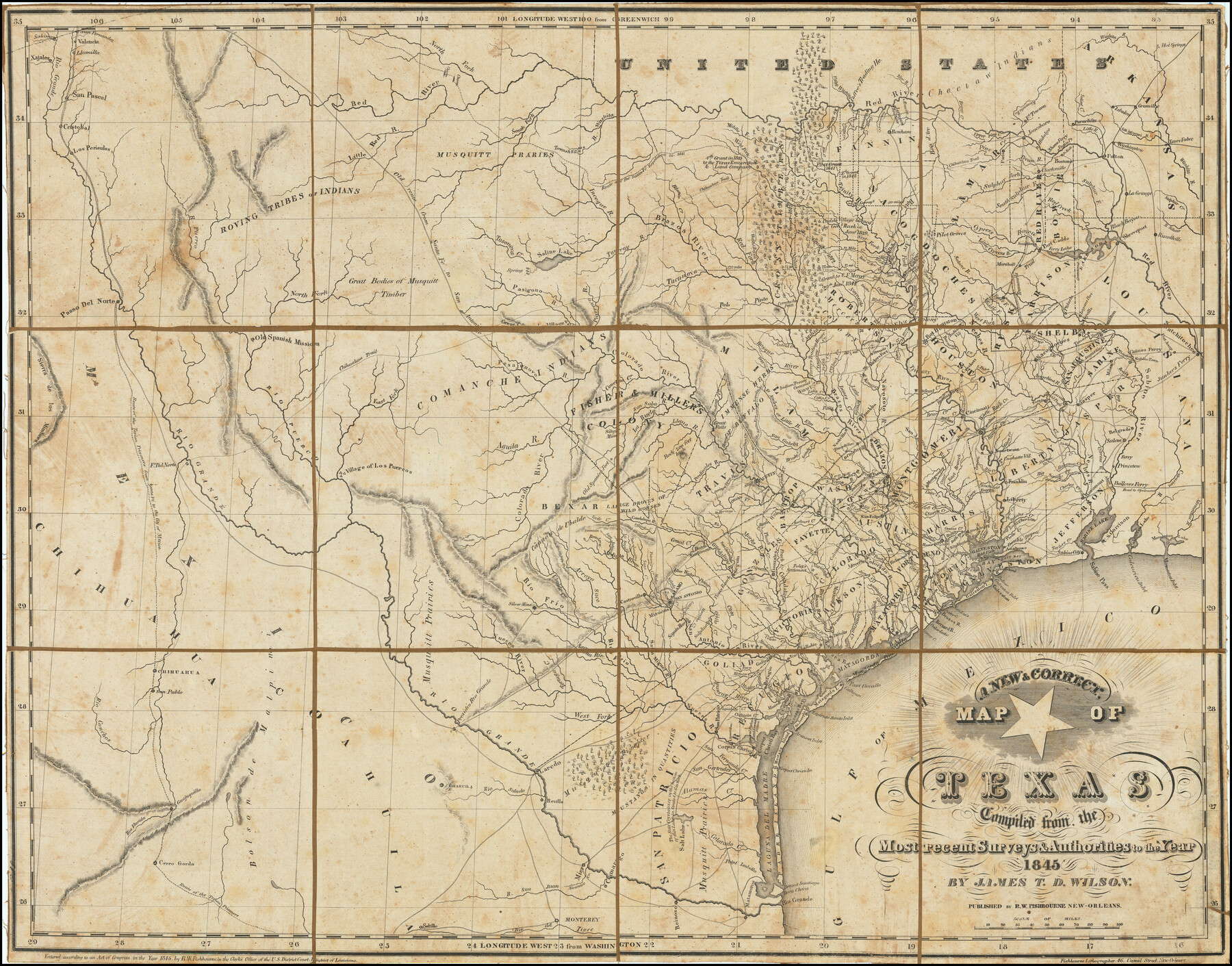
A new & correct map of Texas compiled from the most recent surveys & authorities to the year 1845
-
Map/Doc
96973
-
Collection
Holcomb Map Collection
-
Object Dates
1845 (Creation Date)
-
People and Organizations
R.W. Fishbourne (Publisher)
James T.D. Wilson (Author)
-
Subjects
Republic of Texas
-
Height x Width
22.4 x 28.5 inches
56.9 x 72.4 cm
-
Comments
Courtesy of Frank and Carol Holcomb.
Part of: Holcomb Map Collection
Richardson's New Map of the State of Texas, corrected for the Texas Almanac to 1872

Print $20.00
- Digital $50.00
Richardson's New Map of the State of Texas, corrected for the Texas Almanac to 1872
1872
Size 19.2 x 26.6 inches
Map/Doc 97525
Americae Sive Novi Orbis Nova Descriptio

Print $20.00
- Digital $50.00
Americae Sive Novi Orbis Nova Descriptio
1606
Size 16.5 x 22.4 inches
Map/Doc 93810
Map of South America designed to accompany Smith's Geography of Schools

Print $20.00
- Digital $50.00
Map of South America designed to accompany Smith's Geography of Schools
1850
Size 12.0 x 9.8 inches
Map/Doc 93891
The History of Texas; or, the Emigrants, Farmer's, and Politician's Guide to the Character, Climate, Soil and Productions of that Country; geographically arranged from personal observation and experience.

Print $692.00
- Digital $50.00
The History of Texas; or, the Emigrants, Farmer's, and Politician's Guide to the Character, Climate, Soil and Productions of that Country; geographically arranged from personal observation and experience.
1836
Size 8.1 x 5.3 inches
Map/Doc 93856
America with those known parts in that unknowne worlde both people and manner of buildings

Print $20.00
- Digital $50.00
America with those known parts in that unknowne worlde both people and manner of buildings
1626
Size 17.1 x 22.2 inches
Map/Doc 93816
Map of the Texas & Pacific Railway and connections

Print $20.00
- Digital $50.00
Map of the Texas & Pacific Railway and connections
1902
Size 18.0 x 36.8 inches
Map/Doc 95413
Map of the United States of America, the British Provinces, Mexico, the West Indies and Central America with part of New Granada and Venezuela

Print $20.00
- Digital $50.00
Map of the United States of America, the British Provinces, Mexico, the West Indies and Central America with part of New Granada and Venezuela
1855
Size 34.7 x 44.0 inches
Map/Doc 93904
Map of North America designed to accompany Smith's Geography for Schools

Print $20.00
- Digital $50.00
Map of North America designed to accompany Smith's Geography for Schools
1850
Size 12.0 x 9.9 inches
Map/Doc 93883
North America and the West Indies

Print $20.00
- Digital $50.00
North America and the West Indies
1763
Size 41.6 x 46.9 inches
Map/Doc 93834
Americae Pars Borealis, Florida, Baccalaos, Canada, Corterealis

Print $20.00
- Digital $50.00
Americae Pars Borealis, Florida, Baccalaos, Canada, Corterealis
1593
Size 16.2 x 22.1 inches
Map/Doc 93832
Carta Geografica General de la Republica Mexicana

Print $40.00
- Digital $50.00
Carta Geografica General de la Republica Mexicana
1845
Size 38.1 x 52.9 inches
Map/Doc 96438
Fredonia or the United States of North-America; including also Cabotia, or the Canadian Provinces; the Western Territory to the Pacific Ocean; and the Northern Part of the Mexican States

Print $20.00
- Digital $50.00
Fredonia or the United States of North-America; including also Cabotia, or the Canadian Provinces; the Western Territory to the Pacific Ocean; and the Northern Part of the Mexican States
1848
Size 26.8 x 39.9 inches
Map/Doc 93879
You may also like
Presidio County Rolled Sketch 68

Print $20.00
- Digital $50.00
Presidio County Rolled Sketch 68
1927
Size 11.8 x 24.4 inches
Map/Doc 7358
Kinney County Rolled Sketch 6

Print $20.00
- Digital $50.00
Kinney County Rolled Sketch 6
Size 27.1 x 36.8 inches
Map/Doc 6536
Matagorda County NRC Article 33.136 Sketch 22

Print $24.00
Matagorda County NRC Article 33.136 Sketch 22
2025
Map/Doc 97486
Val Verde County Sketch File L

Print $26.00
- Digital $50.00
Val Verde County Sketch File L
1919
Size 12.4 x 9.1 inches
Map/Doc 39262
[Blocks DT, P, CK, C2, and D7]
![91307, [Blocks DT, P, CK, C2, and D7], Twichell Survey Records](https://historictexasmaps.com/wmedia_w700/maps/91307-1.tif.jpg)
Print $20.00
- Digital $50.00
[Blocks DT, P, CK, C2, and D7]
Size 23.6 x 9.6 inches
Map/Doc 91307


Scurry County Rolled Sketch 1

Print $40.00
- Digital $50.00
Scurry County Rolled Sketch 1
Size 70.5 x 44.9 inches
Map/Doc 9910
[Famous Heights Addition to Amarillo, Texas]
![91786, [Famous Heights Addition to Amarillo, Texas], Twichell Survey Records](https://historictexasmaps.com/wmedia_w700/maps/91786-1.tif.jpg)
Print $20.00
- Digital $50.00
[Famous Heights Addition to Amarillo, Texas]
Size 20.3 x 15.6 inches
Map/Doc 91786
Plan of the City of Galveston, Texas

Print $20.00
- Digital $50.00
Plan of the City of Galveston, Texas
1845
Size 18.4 x 27.8 inches
Map/Doc 62970
[Galveston, Harrisburg & San Antonio Railroad from Cuero to Stockdale]
![64191, [Galveston, Harrisburg & San Antonio Railroad from Cuero to Stockdale], General Map Collection](https://historictexasmaps.com/wmedia_w700/maps/64191.tif.jpg)
Print $20.00
- Digital $50.00
[Galveston, Harrisburg & San Antonio Railroad from Cuero to Stockdale]
1907
Size 14.2 x 34.2 inches
Map/Doc 64191
Flight Mission No. DQN-1K, Frame 30, Calhoun County

Print $20.00
- Digital $50.00
Flight Mission No. DQN-1K, Frame 30, Calhoun County
1953
Size 18.6 x 22.2 inches
Map/Doc 84135