Bexar County Working Sketch 2
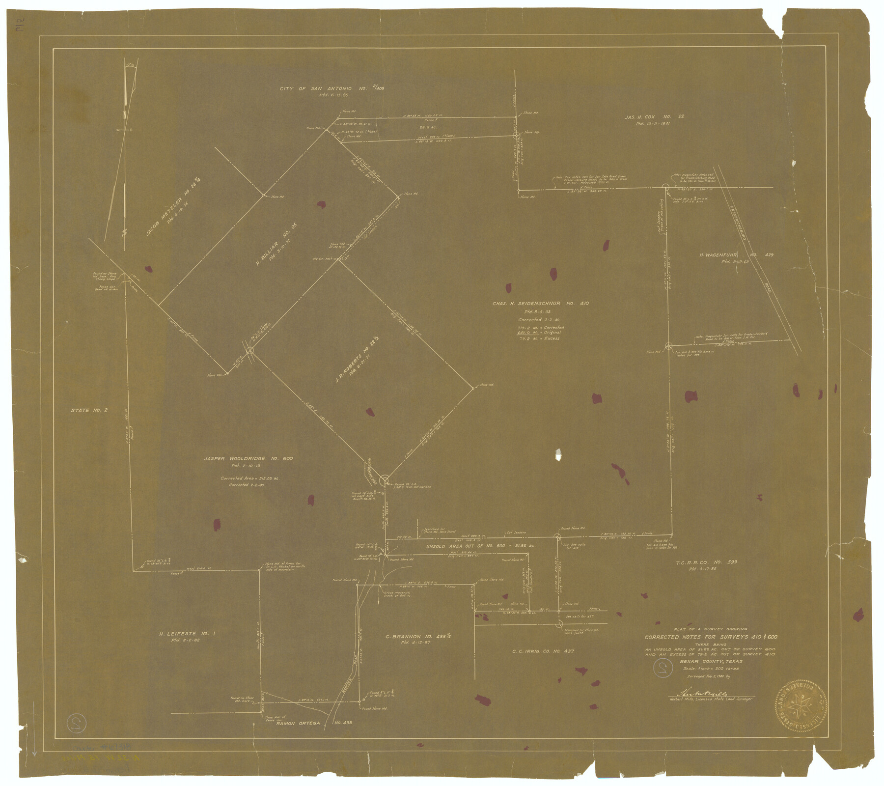
Plat of a survey showing corrected notes for surveys 410 & 600
-
Map/Doc
67318
-
Collection
General Map Collection
-
Object Dates
2/2/1940 (Creation Date)
-
People and Organizations
Herbert Mills (Surveyor/Engineer)
-
Counties
Bexar
-
Subjects
Surveying Working Sketch
-
Height x Width
24.8 x 27.9 inches
63.0 x 70.9 cm
-
Scale
1" = 200 varas
-
Comments
Surveys located about 15 miles North 34 degrees West of San Antonio, Texas.
Received in office February 13, 1940.
Part of: General Map Collection
Galveston County Sketch File 11b

Print $4.00
- Digital $50.00
Galveston County Sketch File 11b
1876
Size 8.9 x 8.9 inches
Map/Doc 23378
Brown County Working Sketch 14

Print $20.00
- Digital $50.00
Brown County Working Sketch 14
1989
Size 20.1 x 21.3 inches
Map/Doc 67779
Guadalupe County Sketch File 23

Print $22.00
- Digital $50.00
Guadalupe County Sketch File 23
1859
Size 25.5 x 19.0 inches
Map/Doc 11592
Flight Mission No. DAH-17M, Frame 68, Orange County

Print $20.00
- Digital $50.00
Flight Mission No. DAH-17M, Frame 68, Orange County
1953
Size 18.6 x 22.4 inches
Map/Doc 86902
Flight Mission No. DCL-7C, Frame 78, Kenedy County

Print $20.00
- Digital $50.00
Flight Mission No. DCL-7C, Frame 78, Kenedy County
1943
Size 15.3 x 15.2 inches
Map/Doc 86064
Red River County Sketch File 27

Print $4.00
- Digital $50.00
Red River County Sketch File 27
1848
Size 12.8 x 8.3 inches
Map/Doc 35163
Flight Mission No. DQN-5K, Frame 24, Calhoun County

Print $20.00
- Digital $50.00
Flight Mission No. DQN-5K, Frame 24, Calhoun County
1953
Size 18.5 x 22.1 inches
Map/Doc 84375
Mills County Working Sketch 11

Print $20.00
- Digital $50.00
Mills County Working Sketch 11
1930
Size 22.5 x 14.4 inches
Map/Doc 71041

San Patricio County Working Sketch 9

Print $40.00
- Digital $50.00
San Patricio County Working Sketch 9
1937
Size 52.8 x 44.0 inches
Map/Doc 63771
Midland County Working Sketch 9

Print $20.00
- Digital $50.00
Midland County Working Sketch 9
1951
Size 42.6 x 35.9 inches
Map/Doc 70989
Madison County Working Sketch 13

Print $20.00
- Digital $50.00
Madison County Working Sketch 13
1995
Size 15.5 x 22.9 inches
Map/Doc 70775
You may also like
Young Territory

Print $20.00
- Digital $50.00
Young Territory
1874
Size 29.4 x 29.2 inches
Map/Doc 1977
Hutchinson County Rolled Sketch 40

Print $20.00
- Digital $50.00
Hutchinson County Rolled Sketch 40
1981
Size 26.2 x 37.4 inches
Map/Doc 6305
Eastland County Working Sketch 14

Print $20.00
- Digital $50.00
Eastland County Working Sketch 14
1919
Size 18.2 x 17.1 inches
Map/Doc 68795
Menard County Working Sketch 25

Print $20.00
- Digital $50.00
Menard County Working Sketch 25
1952
Size 32.2 x 42.8 inches
Map/Doc 70972
[S.P.R.R.Co. Blocks 15 &16]
![92355, [S.P.R.R.Co. Blocks 15 &16], Twichell Survey Records](https://historictexasmaps.com/wmedia_w700/maps/92355-1.tif.jpg)
Print $20.00
- Digital $50.00
[S.P.R.R.Co. Blocks 15 &16]
Size 37.3 x 32.3 inches
Map/Doc 92355
A Sketch of the Vice Royalty exhibiting the several Provinces and its Aproximation [sic] to the Internal Provinces of New Spain
![95157, A Sketch of the Vice Royalty exhibiting the several Provinces and its Aproximation [sic] to the Internal Provinces of New Spain, General Map Collection](https://historictexasmaps.com/wmedia_w700/maps/95157.tif.jpg)
Print $20.00
- Digital $50.00
A Sketch of the Vice Royalty exhibiting the several Provinces and its Aproximation [sic] to the Internal Provinces of New Spain
1810
Size 15.2 x 21.1 inches
Map/Doc 95157
Northwest Section of Ramsey State Farm

Print $20.00
- Digital $50.00
Northwest Section of Ramsey State Farm
Size 12.6 x 17.2 inches
Map/Doc 94281
Texas in 1835

Print $20.00
- Digital $50.00
Texas in 1835
1897
Size 13.4 x 15.3 inches
Map/Doc 93414
Briscoe County Boundary File 3

Print $4.00
- Digital $50.00
Briscoe County Boundary File 3
Size 13.9 x 8.5 inches
Map/Doc 50778
Harris County Rolled Sketch 33

Print $20.00
- Digital $50.00
Harris County Rolled Sketch 33
1912
Size 26.0 x 34.5 inches
Map/Doc 6097
Gaines County Sketch File 5

Print $22.00
- Digital $50.00
Gaines County Sketch File 5
1915
Size 10.8 x 7.2 inches
Map/Doc 23177
Rand McNally Main Highway Map of Texas

Print $20.00
Rand McNally Main Highway Map of Texas
1923
Size 27.7 x 40.3 inches
Map/Doc 76260