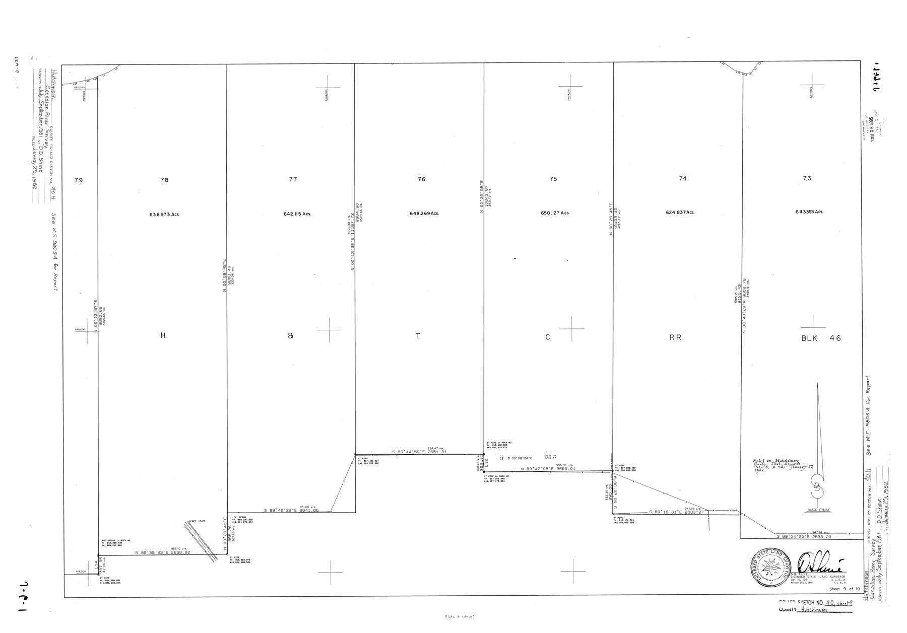
Hutchinson County Rolled Sketch 40
[Canadian River Survey, Hutchinson County, Texas - Sheet 9 of 10]
-
Map/Doc
6305
-
Collection
General Map Collection
-
Object Dates
1981/12/1 (Revision Date)
1982/1/29 (File Date)
1981/10/19 (Creation Date)
-
People and Organizations
D.D. Shine (Surveyor/Engineer)
-
Counties
Hutchinson
-
Subjects
Surveying Rolled Sketch
-
Height x Width
26.2 x 37.4 inches
66.5 x 95.0 cm
-
Medium
mylar, print
-
Scale
1" = 500 feet
Related maps
Hutchinson County Sketch File 46

Print $50.00
- Digital $50.00
Hutchinson County Sketch File 46
1981
Size 11.2 x 8.7 inches
Map/Doc 27365
Part of: General Map Collection
[T&P Land Reserve, Blocks 33, 34 & 35, Tsps. 2, 3, 4, & 5, Dawson & Martin Counties, Texas

Print $20.00
- Digital $50.00
[T&P Land Reserve, Blocks 33, 34 & 35, Tsps. 2, 3, 4, & 5, Dawson & Martin Counties, Texas
1875
Size 29.6 x 34.9 inches
Map/Doc 2223
Oldham County Rolled Sketch 11

Print $40.00
- Digital $50.00
Oldham County Rolled Sketch 11
Size 48.6 x 39.9 inches
Map/Doc 10641
[Map of Texas and Indian Territory]
![93757, [Map of Texas and Indian Territory], General Map Collection](https://historictexasmaps.com/wmedia_w700/maps/93757-1.tif.jpg)
Print $20.00
- Digital $50.00
[Map of Texas and Indian Territory]
1878
Size 26.2 x 20.1 inches
Map/Doc 93757
Glasscock County Rolled Sketch 8

Print $20.00
- Digital $50.00
Glasscock County Rolled Sketch 8
1951
Size 38.4 x 32.3 inches
Map/Doc 9056
Menard County Working Sketch 15

Print $20.00
- Digital $50.00
Menard County Working Sketch 15
1943
Size 18.6 x 20.6 inches
Map/Doc 70962
Cette Carte de Californie et du Nouveau Mexique est tiree de celle qui a ete envoyee par un grand d'Espagne pour etre communiquee a Mrs. de l'Academie Royale des Sciences

Print $20.00
- Digital $50.00
Cette Carte de Californie et du Nouveau Mexique est tiree de celle qui a ete envoyee par un grand d'Espagne pour etre communiquee a Mrs. de l'Academie Royale des Sciences
1700
Size 11.8 x 16.5 inches
Map/Doc 95924
Coast Chart No. 210 Aransas Pass and Corpus Christi Bay with the coast to latitude 27° 12' Texas

Print $20.00
- Digital $50.00
Coast Chart No. 210 Aransas Pass and Corpus Christi Bay with the coast to latitude 27° 12' Texas
1887
Size 27.3 x 18.2 inches
Map/Doc 72792
Liberty County Rolled Sketch OB-1

Print $40.00
- Digital $50.00
Liberty County Rolled Sketch OB-1
1934
Size 70.7 x 25.1 inches
Map/Doc 9564
Culberson County Working Sketch 25

Print $40.00
- Digital $50.00
Culberson County Working Sketch 25
1951
Size 36.9 x 52.5 inches
Map/Doc 62343
Jackson County Working Sketch 12

Print $20.00
- Digital $50.00
Jackson County Working Sketch 12
Size 31.2 x 33.0 inches
Map/Doc 66460
Hood County Sketch File 4

Print $4.00
- Digital $50.00
Hood County Sketch File 4
Size 8.8 x 7.8 inches
Map/Doc 26575
Morris County Rolled Sketch 2A

Print $20.00
- Digital $50.00
Morris County Rolled Sketch 2A
Size 24.2 x 19.1 inches
Map/Doc 10249
You may also like
Bee County Working Sketch 14

Print $20.00
- Digital $50.00
Bee County Working Sketch 14
1948
Size 22.2 x 17.7 inches
Map/Doc 67264
Pecos County Working Sketch Graphic Index - northeast part - sheet B

Print $20.00
- Digital $50.00
Pecos County Working Sketch Graphic Index - northeast part - sheet B
1975
Size 36.0 x 42.2 inches
Map/Doc 76667
No. 3 Chart of Channel connecting Corpus Christi Bay with Aransas Bay, Texas

Print $20.00
- Digital $50.00
No. 3 Chart of Channel connecting Corpus Christi Bay with Aransas Bay, Texas
1878
Size 18.2 x 28.0 inches
Map/Doc 72772
Matagorda County Sketch File 27

Print $60.00
- Digital $50.00
Matagorda County Sketch File 27
1908
Size 11.8 x 15.7 inches
Map/Doc 30803
Sketch Showing Surveys Made for W. R. Cartledge

Print $20.00
- Digital $50.00
Sketch Showing Surveys Made for W. R. Cartledge
1945
Size 16.9 x 14.4 inches
Map/Doc 2059
General Highway Map, Hamilton County, Texas

Print $20.00
General Highway Map, Hamilton County, Texas
1940
Size 18.4 x 24.9 inches
Map/Doc 79111
Concho County

Print $20.00
- Digital $50.00
Concho County
1947
Size 40.6 x 31.5 inches
Map/Doc 77247
Kerr County Sketch File 12

Print $4.00
- Digital $50.00
Kerr County Sketch File 12
1901
Size 6.7 x 11.1 inches
Map/Doc 28881
Jeff Davis County Working Sketch 9

Print $20.00
- Digital $50.00
Jeff Davis County Working Sketch 9
1943
Size 28.5 x 27.3 inches
Map/Doc 66504
Railroad Track Map, H&TCRRCo., Falls County, Texas

Print $4.00
- Digital $50.00
Railroad Track Map, H&TCRRCo., Falls County, Texas
1918
Size 11.8 x 18.6 inches
Map/Doc 62836
Hutchinson County Working Sketch 24

Print $20.00
- Digital $50.00
Hutchinson County Working Sketch 24
1967
Size 27.2 x 40.0 inches
Map/Doc 66384
Stephens County Sketch File 10

Print $4.00
- Digital $50.00
Stephens County Sketch File 10
Size 10.8 x 8.4 inches
Map/Doc 37042