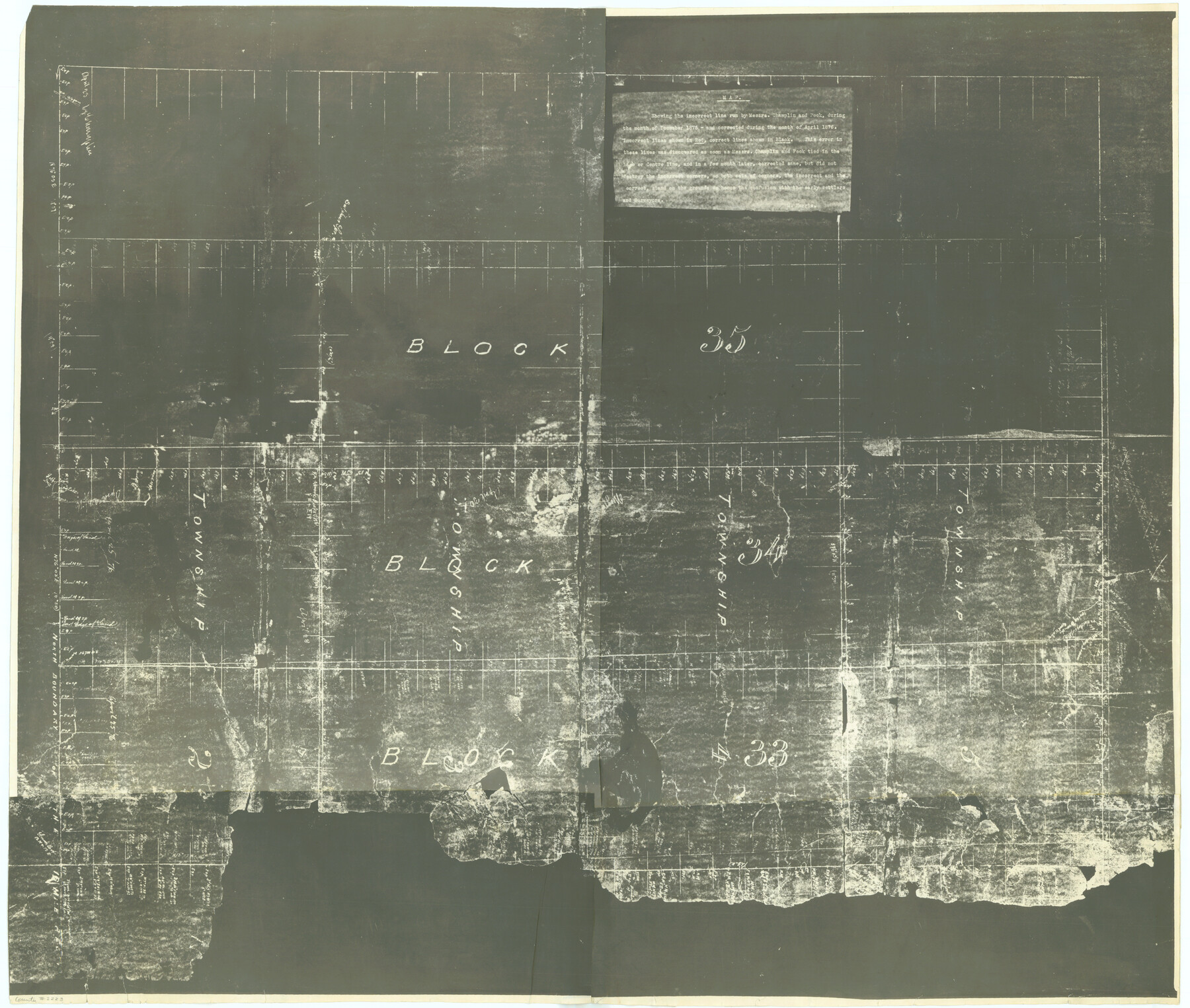
[T&P Land Reserve, Blocks 33, 34 & 35, Tsps. 2, 3, 4, & 5, Dawson & Martin Counties, Texas
K-7-21
-
Map/Doc
2223
-
Collection
General Map Collection
-
Object Dates
1875 (Creation Date)
-
People and Organizations
Texas and Pacific Railroad Company (Author)
-
Counties
Dawson Martin
-
Height x Width
29.6 x 34.9 inches
75.2 x 88.6 cm
-
Comments
Map showing incorrect line run by Champlin and Peck December 1875 and corrected in April 1876. Two sets of corners now on ground.
Part of: General Map Collection
Map of Portland, Texas in San Patricio County

Print $20.00
- Digital $50.00
Map of Portland, Texas in San Patricio County
Size 39.8 x 46.0 inches
Map/Doc 48886
Intracoastal Waterway - Galveston Bay to West Bay including Galveston Bay Entrance

Print $20.00
- Digital $50.00
Intracoastal Waterway - Galveston Bay to West Bay including Galveston Bay Entrance
1962
Size 26.8 x 38.4 inches
Map/Doc 69937
Controlled Mosaic by Jack Amman Photogrammetric Engineers, Inc - Sheet 14

Print $20.00
- Digital $50.00
Controlled Mosaic by Jack Amman Photogrammetric Engineers, Inc - Sheet 14
1954
Size 20.0 x 24.0 inches
Map/Doc 83458
Anderson County Working Sketch 45

Print $20.00
- Digital $50.00
Anderson County Working Sketch 45
1993
Size 41.8 x 38.0 inches
Map/Doc 67045
Andrews County Working Sketch 18

Print $20.00
- Digital $50.00
Andrews County Working Sketch 18
1964
Size 42.2 x 26.5 inches
Map/Doc 67064
Waller County Sketch File 2a

Print $4.00
- Digital $50.00
Waller County Sketch File 2a
Size 8.0 x 8.4 inches
Map/Doc 39596
Red River County Working Sketch 64

Print $20.00
- Digital $50.00
Red River County Working Sketch 64
1973
Size 26.1 x 32.3 inches
Map/Doc 72047
Aransas County Working Sketch 23

Print $20.00
- Digital $50.00
Aransas County Working Sketch 23
1970
Size 34.6 x 40.1 inches
Map/Doc 67190
Aransas County Boundary File 4

Print $30.00
- Digital $50.00
Aransas County Boundary File 4
Size 9.2 x 7.8 inches
Map/Doc 49790
Frio County Sketch File 17

Print $6.00
- Digital $50.00
Frio County Sketch File 17
1955
Size 14.3 x 8.7 inches
Map/Doc 23152
Jeff Davis County Rolled Sketch 44

Print $20.00
- Digital $50.00
Jeff Davis County Rolled Sketch 44
2014
Size 19.8 x 34.7 inches
Map/Doc 94243

You may also like
Louisiana and Texas Intracoastal Waterway - Entrance near Port O'Connor, Texas, Survey of September, 1940

Print $20.00
- Digital $50.00
Louisiana and Texas Intracoastal Waterway - Entrance near Port O'Connor, Texas, Survey of September, 1940
1940
Size 31.2 x 41.5 inches
Map/Doc 61822
[Galveston, Harrisburg & San Antonio Railroad from Cuero to Stockdale]
![64196, [Galveston, Harrisburg & San Antonio Railroad from Cuero to Stockdale], General Map Collection](https://historictexasmaps.com/wmedia_w700/maps/64196.tif.jpg)
Print $20.00
- Digital $50.00
[Galveston, Harrisburg & San Antonio Railroad from Cuero to Stockdale]
1907
Size 13.7 x 34.0 inches
Map/Doc 64196
Eastland County Rolled Sketch 24

Print $20.00
- Digital $50.00
Eastland County Rolled Sketch 24
1983
Size 33.5 x 38.0 inches
Map/Doc 8830
The T. B. Duggan Subdivision of League 125 and N 3/5 of League 126, Coke County School Lands, Cochran County, Texas

Print $20.00
- Digital $50.00
The T. B. Duggan Subdivision of League 125 and N 3/5 of League 126, Coke County School Lands, Cochran County, Texas
1920
Size 14.9 x 21.5 inches
Map/Doc 90300
Culberson County Sketch File EM and RJ

Print $24.00
- Digital $50.00
Culberson County Sketch File EM and RJ
Size 13.3 x 8.8 inches
Map/Doc 20157
Denton County Working Sketch 15

Print $20.00
- Digital $50.00
Denton County Working Sketch 15
1971
Size 21.7 x 30.0 inches
Map/Doc 68620
Hutchinson County Sketch File 6a

Print $42.00
- Digital $50.00
Hutchinson County Sketch File 6a
1898
Size 7.6 x 8.6 inches
Map/Doc 27202
Current Miscellaneous File 59

Print $16.00
- Digital $50.00
Current Miscellaneous File 59
1836
Size 11.4 x 8.9 inches
Map/Doc 74056
Trinity River, Clapps Ferry Sheet

Print $20.00
- Digital $50.00
Trinity River, Clapps Ferry Sheet
1925
Size 47.5 x 36.4 inches
Map/Doc 65180
PSL Field Notes for Block B9 in Ector and Winkler Counties, Block B13 in Ector, Ward, and Winkler Counties, and Blocks A55, A56, A57, B1, B2, B3, B5, B6, B7, B10, B11, and B12 in Winkler County

PSL Field Notes for Block B9 in Ector and Winkler Counties, Block B13 in Ector, Ward, and Winkler Counties, and Blocks A55, A56, A57, B1, B2, B3, B5, B6, B7, B10, B11, and B12 in Winkler County
Map/Doc 81676
Montgomery County Rolled Sketch 51

Print $20.00
- Digital $50.00
Montgomery County Rolled Sketch 51
2021
Map/Doc 97369
Brassos Santiago

Print $20.00
- Digital $50.00
Brassos Santiago
1853
Size 25.3 x 18.3 inches
Map/Doc 72913