Frio County Sketch File 17
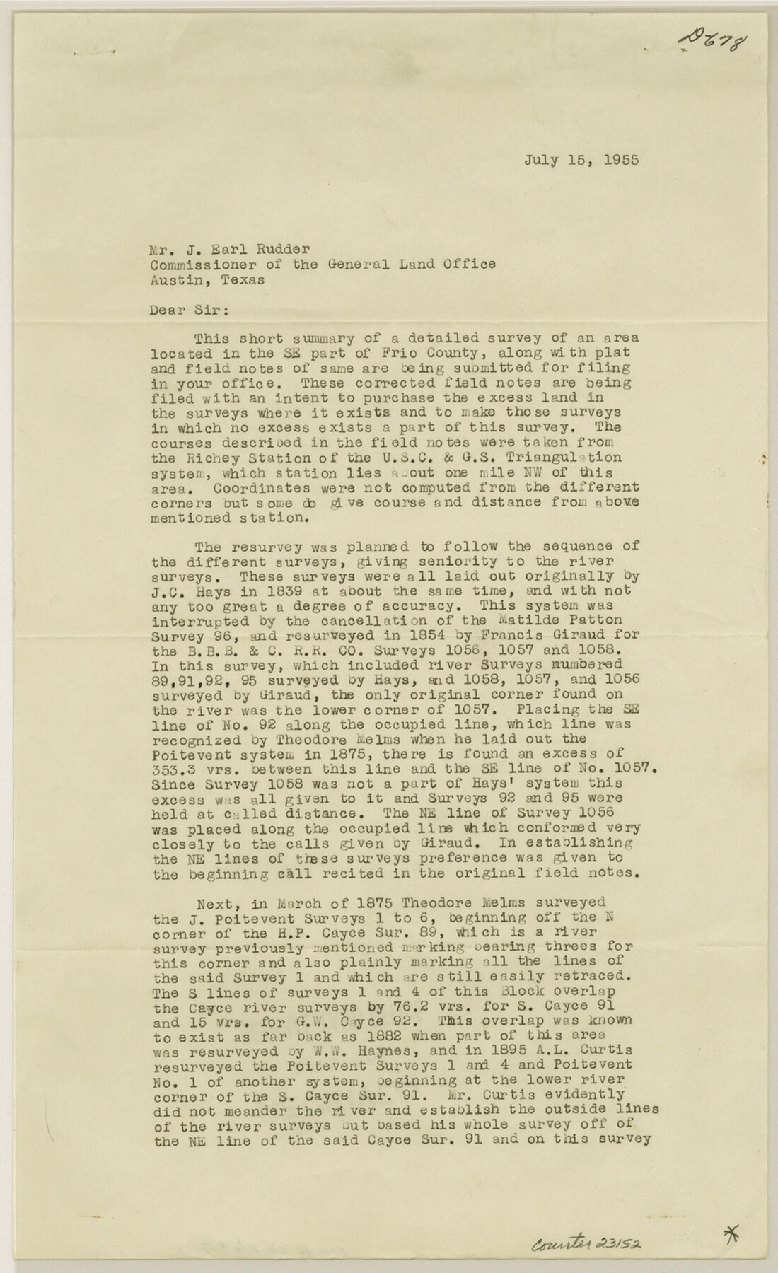
[Surveyor's report regarding survey of the Hildebrand lands, southeast of Pearsall]
-
Map/Doc
23152
-
Collection
General Map Collection
-
Object Dates
1955/7/15 (Creation Date)
1955/8/2 (File Date)
1839 (Survey Date)
1875 (Survey Date)
1882 (Survey Date)
1895 (Survey Date)
1876 (Survey Date)
-
People and Organizations
Frank J. Schorp (Surveyor/Engineer)
J.C. Hays (Surveyor/Engineer)
Giraud (Surveyor/Engineer)
Theodore Melms (Surveyor/Engineer)
W.W. Haynes (Surveyor/Engineer)
A.L. Curtis (Surveyor/Engineer)
-
Counties
Frio
-
Subjects
Surveying Sketch File
-
Height x Width
14.3 x 8.7 inches
36.3 x 22.1 cm
-
Medium
paper, print
-
Comments
See Frio County Rolled Sketch 18 (8908) for sketch.
-
Features
Cayce River
Related maps
Frio County Rolled Sketch 18

Print $20.00
- Digital $50.00
Frio County Rolled Sketch 18
1955
Size 41.2 x 43.4 inches
Map/Doc 8908
Part of: General Map Collection
Flight Mission No. DQO-8K, Frame 43, Galveston County

Print $20.00
- Digital $50.00
Flight Mission No. DQO-8K, Frame 43, Galveston County
1952
Size 18.6 x 22.3 inches
Map/Doc 85150
Nueces County Rolled Sketch 125

Print $34.00
Nueces County Rolled Sketch 125
1998
Size 18.1 x 25.0 inches
Map/Doc 7160
Parker County Sketch File 19

Print $6.00
- Digital $50.00
Parker County Sketch File 19
1876
Size 11.7 x 10.3 inches
Map/Doc 33556

Stonewall County Working Sketch 7

Print $20.00
- Digital $50.00
Stonewall County Working Sketch 7
1949
Size 30.7 x 24.5 inches
Map/Doc 62314
Sketch showing progress of topographical work Laguna Madre and vicinity from Rainey Is. to Baffins Bay, Coast of Texas Sect. IX [and accompanying letter]
![72957, Sketch showing progress of topographical work Laguna Madre and vicinity from Rainey Is. to Baffins Bay, Coast of Texas Sect. IX [and accompanying letter], General Map Collection](https://historictexasmaps.com/wmedia_w700/maps/72957.tif.jpg)
Print $20.00
- Digital $50.00
Sketch showing progress of topographical work Laguna Madre and vicinity from Rainey Is. to Baffins Bay, Coast of Texas Sect. IX [and accompanying letter]
1880
Size 39.2 x 18.6 inches
Map/Doc 72957
Vacancy Application - John H. Tyler near T.C. Ry. Co. Block 1 Surveys 101, 102, 103, & 104. Letters and Maps, Pecos County

Print $279.00
- Digital $50.00
Vacancy Application - John H. Tyler near T.C. Ry. Co. Block 1 Surveys 101, 102, 103, & 104. Letters and Maps, Pecos County
1934
Size 18.1 x 21.1 inches
Map/Doc 2048
Hudspeth County Rolled Sketch 43A

Print $3.00
- Digital $50.00
Hudspeth County Rolled Sketch 43A
1958
Size 10.7 x 8.8 inches
Map/Doc 6252
Brewster County Rolled Sketch 101

Print $40.00
- Digital $50.00
Brewster County Rolled Sketch 101
1927
Size 73.0 x 44.9 inches
Map/Doc 8923
Hockley County

Print $20.00
- Digital $50.00
Hockley County
1900
Size 41.5 x 36.7 inches
Map/Doc 16852
McLennan County Sketch File 1b

Print $4.00
- Digital $50.00
McLennan County Sketch File 1b
Size 8.3 x 8.1 inches
Map/Doc 31228
Texas Gulf Coast Map from the Sabine River to the Rio Grande as subdivided for mineral development

Print $40.00
- Digital $50.00
Texas Gulf Coast Map from the Sabine River to the Rio Grande as subdivided for mineral development
Size 117.9 x 46.0 inches
Map/Doc 2902
You may also like
Flight Mission No. BRA-16M, Frame 130, Jefferson County

Print $20.00
- Digital $50.00
Flight Mission No. BRA-16M, Frame 130, Jefferson County
1953
Size 18.5 x 22.5 inches
Map/Doc 85740
Flight Mission No. CRK-3P, Frame 68, Refugio County

Print $20.00
- Digital $50.00
Flight Mission No. CRK-3P, Frame 68, Refugio County
1956
Size 18.7 x 22.5 inches
Map/Doc 86910
Reagan County Rolled Sketch 17A

Print $20.00
- Digital $50.00
Reagan County Rolled Sketch 17A
1948
Size 33.8 x 32.4 inches
Map/Doc 9813
Flight Mission No. DCL-6C, Frame 126, Kenedy County

Print $20.00
- Digital $50.00
Flight Mission No. DCL-6C, Frame 126, Kenedy County
1943
Size 18.5 x 22.3 inches
Map/Doc 85956
[Area south of Runnels County School Land]
![93168, [Area south of Runnels County School Land], Twichell Survey Records](https://historictexasmaps.com/wmedia_w700/maps/93168-1.tif.jpg)
Print $40.00
- Digital $50.00
[Area south of Runnels County School Land]
Size 87.7 x 42.9 inches
Map/Doc 93168
Brewster County Rolled Sketch 62

Print $40.00
- Digital $50.00
Brewster County Rolled Sketch 62
1939
Size 89.5 x 44.0 inches
Map/Doc 8487
Fisher County Rolled Sketch 5

Print $20.00
- Digital $50.00
Fisher County Rolled Sketch 5
1961
Size 39.1 x 33.7 inches
Map/Doc 8890
Hudspeth County Working Sketch 2

Print $20.00
- Digital $50.00
Hudspeth County Working Sketch 2
1912
Size 22.3 x 17.7 inches
Map/Doc 66283
Oil Development and Structural Map showing Schott, Mirando and other oil fields of the Laredo District with present and proposed development.

Print $20.00
- Digital $50.00
Oil Development and Structural Map showing Schott, Mirando and other oil fields of the Laredo District with present and proposed development.
1920
Size 11.3 x 8.9 inches
Map/Doc 94107
Coleman County Sketch File 45

Print $20.00
- Digital $50.00
Coleman County Sketch File 45
1897
Size 23.9 x 23.8 inches
Map/Doc 11124

Hudspeth County Rolled Sketch 20

Print $20.00
- Digital $50.00
Hudspeth County Rolled Sketch 20
Size 39.5 x 44.3 inches
Map/Doc 76028