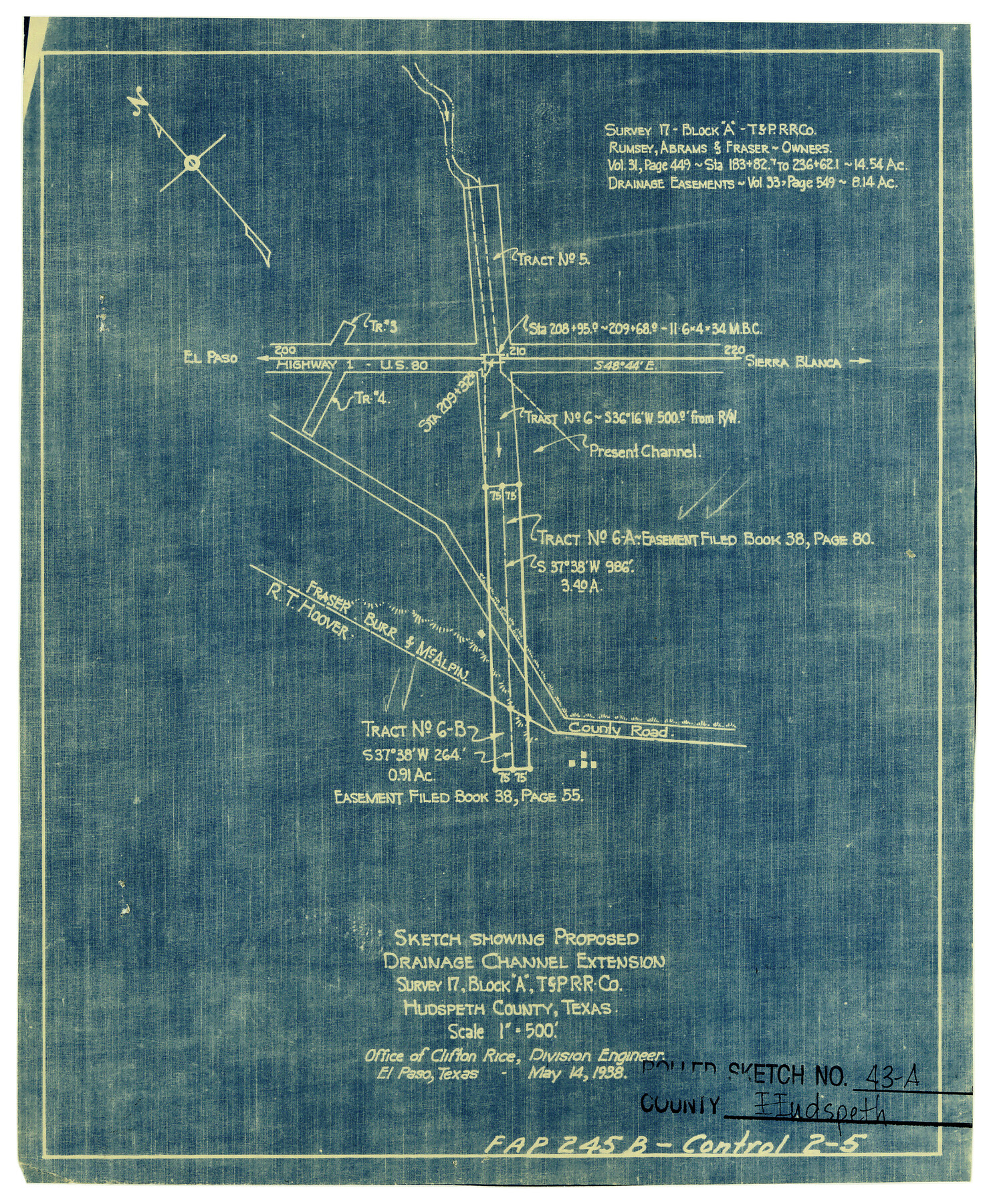
Hudspeth County Rolled Sketch 43A
Sketch showing proposed drainage channel extension; Survey 17, Block A, T. & P. R.R. Co.
-
Map/Doc
6252
-
Collection
General Map Collection
-
Object Dates
5/14/1958 (Creation Date)
-
People and Organizations
Clifton Rice (Surveyor/Engineer)
-
Counties
Hudspeth
-
Subjects
Surveying Rolled Sketch
-
Height x Width
10.7 x 8.8 inches
27.2 x 22.4 cm
-
Medium
blueprint/diazo
-
Scale
1" = 500 feet
Part of: General Map Collection
Ochiltree County State of Texas

Print $20.00
- Digital $50.00
Ochiltree County State of Texas
1889
Size 25.5 x 19.0 inches
Map/Doc 4609
Hudspeth County Working Sketch 54

Print $20.00
- Digital $50.00
Hudspeth County Working Sketch 54
1989
Size 18.8 x 36.2 inches
Map/Doc 66339
Index Map No. 1 - Rio Bravo del Norte section of boundary between the United States & Mexico; agreed upon by the Joint Commission under the Treaty of Guadalupe Hidalgo

Print $20.00
- Digital $50.00
Index Map No. 1 - Rio Bravo del Norte section of boundary between the United States & Mexico; agreed upon by the Joint Commission under the Treaty of Guadalupe Hidalgo
1852
Size 18.5 x 27.4 inches
Map/Doc 72859
Lipscomb County Working Sketch 8

Print $20.00
- Digital $50.00
Lipscomb County Working Sketch 8
1982
Size 42.7 x 23.6 inches
Map/Doc 70584
Jefferson County Working Sketch 40

Print $40.00
- Digital $50.00
Jefferson County Working Sketch 40
1985
Size 58.9 x 42.2 inches
Map/Doc 66584
Map of Titus County

Print $20.00
- Digital $50.00
Map of Titus County
1857
Size 23.8 x 34.3 inches
Map/Doc 4857
Harris County Rolled Sketch 80

Print $20.00
- Digital $50.00
Harris County Rolled Sketch 80
1958
Size 31.1 x 31.0 inches
Map/Doc 6116
Right of Way and Track Map Texas & New Orleans R.R. Co. operated by the T. & N. O. R.R. Co. Dallas-Sabine Branch

Print $40.00
- Digital $50.00
Right of Way and Track Map Texas & New Orleans R.R. Co. operated by the T. & N. O. R.R. Co. Dallas-Sabine Branch
1918
Size 26.1 x 57.1 inches
Map/Doc 64153
Stonewall County Working Sketch 30

Print $20.00
- Digital $50.00
Stonewall County Working Sketch 30
1982
Size 28.6 x 29.0 inches
Map/Doc 62337
Hardin County Working Sketch 39, part 2

Print $40.00
- Digital $50.00
Hardin County Working Sketch 39, part 2
1985
Size 36.0 x 48.5 inches
Map/Doc 63438
Travis County Appraisal District Plat Map 2_0605

Print $20.00
- Digital $50.00
Travis County Appraisal District Plat Map 2_0605
Size 21.4 x 26.4 inches
Map/Doc 94240
Fort Bend County State Real Property Sketch 13

Print $40.00
- Digital $50.00
Fort Bend County State Real Property Sketch 13
1987
Size 36.3 x 47.9 inches
Map/Doc 61687
You may also like
Explorations of the Louisiana Purchase

Explorations of the Louisiana Purchase
2023
Size 8.5 x 11.0 inches
Map/Doc 97183
Map of Lavaca County

Print $20.00
- Digital $50.00
Map of Lavaca County
1853
Size 20.1 x 20.4 inches
Map/Doc 3801
Burnet County Working Sketch 24

Print $20.00
- Digital $50.00
Burnet County Working Sketch 24
1990
Size 19.9 x 26.8 inches
Map/Doc 67867
Montgomery County Sketch File 31

Print $20.00
- Digital $50.00
Montgomery County Sketch File 31
1932
Size 35.2 x 34.1 inches
Map/Doc 10550
Rockwall County Working Sketch 1

Print $20.00
- Digital $50.00
Rockwall County Working Sketch 1
Size 12.5 x 18.4 inches
Map/Doc 63593
Controlled Mosaic by Jack Amman Photogrammetric Engineers, Inc - Sheet 42

Print $20.00
- Digital $50.00
Controlled Mosaic by Jack Amman Photogrammetric Engineers, Inc - Sheet 42
1954
Size 20.0 x 24.0 inches
Map/Doc 83500
Lipscomb County Working Sketch 4

Print $40.00
- Digital $50.00
Lipscomb County Working Sketch 4
1974
Size 51.7 x 43.8 inches
Map/Doc 70580
University Lands, Blocks 38 to 57, Crockett, Reagan, Irion, Schleicher Counties

Print $40.00
- Digital $50.00
University Lands, Blocks 38 to 57, Crockett, Reagan, Irion, Schleicher Counties
Size 34.0 x 53.0 inches
Map/Doc 62946

Sutton County

Print $40.00
- Digital $50.00
Sutton County
1898
Size 39.1 x 56.5 inches
Map/Doc 63051
Atascosa County Working Sketch 21

Print $20.00
- Digital $50.00
Atascosa County Working Sketch 21
1954
Size 26.0 x 22.4 inches
Map/Doc 67217
Schleicher County Rolled Sketch 4

Print $20.00
- Digital $50.00
Schleicher County Rolled Sketch 4
Size 17.4 x 24.5 inches
Map/Doc 7747