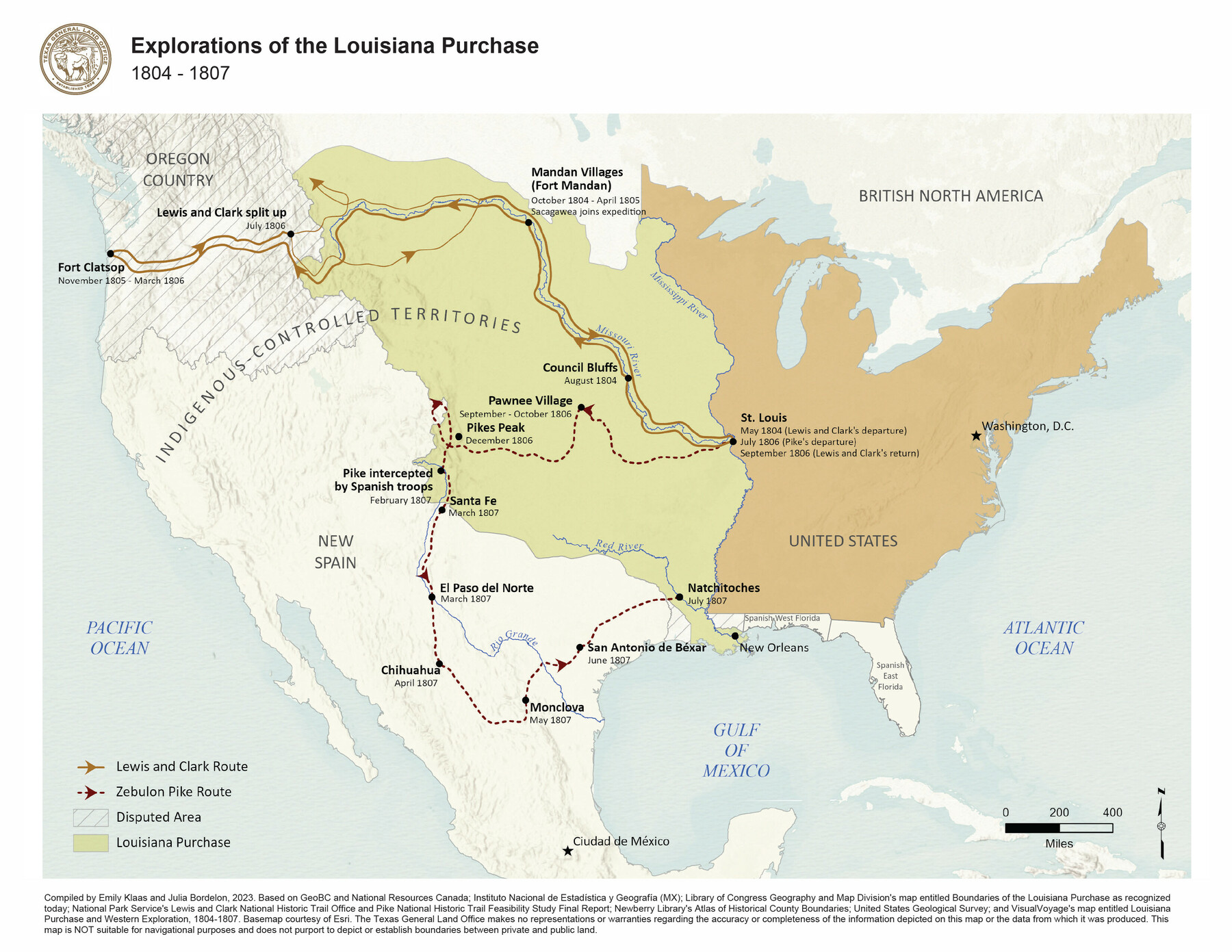
Explorations of the Louisiana Purchase
1804 - 1807
-
Map/Doc
97183
-
Collection
GIS Educational Maps
-
Object Dates
2023 (Creation Date)
-
People and Organizations
Emily Klaas (Compiler)
Julia Bordelon (Compiler)
-
Subjects
Geographic Information System United States
-
Height x Width
8.5 x 11.0 inches
21.6 x 27.9 cm
-
Medium
pdf
Related maps

Part of: GIS Educational Maps

Aerial View of San Antonio de Béxar and Alamo Fortifications

Aerial View of San Antonio de Béxar and Alamo Fortifications
2026
Size 11.0 x 17.0 inches
Map/Doc 97522
Texas Population Distribution in Cities, per the U.S. Census of 1910

Texas Population Distribution in Cities, per the U.S. Census of 1910
2022
Size 11.0 x 8.5 inches
Map/Doc 97092
United States Population Distribution by County and Territory, per the U.S. Census of 1900

United States Population Distribution by County and Territory, per the U.S. Census of 1900
2025
Size 8.5 x 11.0 inches
Map/Doc 97481
Republic of Texas and State of Louisiana Boundary

Republic of Texas and State of Louisiana Boundary
2022
Size 8.5 x 11.0 inches
Map/Doc 96979
Events of the Texas Revolution

Events of the Texas Revolution
2023
Size 11.0 x 17.0 inches
Map/Doc 97194

New Mexico and Adjacent Lands

New Mexico and Adjacent Lands
2022
Size 8.5 x 11.0 inches
Map/Doc 96977
North American Territorial Claims and the Treaty of Paris

North American Territorial Claims and the Treaty of Paris
2025
Size 11.0 x 17.0 inches
Map/Doc 97453
Yellow Fever Deaths in Texas and Louisiana

Yellow Fever Deaths in Texas and Louisiana
2022
Size 8.5 x 11.0 inches
Map/Doc 97094
The Buffalo Bayou, Brazos and Colorado Railroad (BBB&C)

The Buffalo Bayou, Brazos and Colorado Railroad (BBB&C)
2022
Size 8.5 x 11.0 inches
Map/Doc 97088
You may also like
Nueces County NRC Article 33.136 Sketch 22

Print $42.00
Nueces County NRC Article 33.136 Sketch 22
2023
Map/Doc 97180
Hays County Boundary File 1

Print $14.00
- Digital $50.00
Hays County Boundary File 1
Size 9.5 x 5.2 inches
Map/Doc 54586
Hudspeth County Rolled Sketch 73

Print $40.00
- Digital $50.00
Hudspeth County Rolled Sketch 73
1992
Size 38.9 x 49.3 inches
Map/Doc 9236
Map of the Lands Surveyed by the Memphis, El Paso & Pacific R.R. Company

Print $20.00
- Digital $50.00
Map of the Lands Surveyed by the Memphis, El Paso & Pacific R.R. Company
1859
Size 11.4 x 18.6 inches
Map/Doc 4850
Harris County Working Sketch 32

Print $20.00
- Digital $50.00
Harris County Working Sketch 32
1936
Size 34.7 x 41.8 inches
Map/Doc 65924
Newton County Rolled Sketch 26

Print $397.00
- Digital $50.00
Newton County Rolled Sketch 26
1960
Size 10.9 x 15.4 inches
Map/Doc 47265
General Highway Map, Gray County, Texas

Print $20.00
General Highway Map, Gray County, Texas
1961
Size 18.1 x 24.7 inches
Map/Doc 79483
Erath County Sketch File 33

Print $11.00
- Digital $50.00
Erath County Sketch File 33
1962
Size 14.4 x 8.8 inches
Map/Doc 22315
Montague County Sketch File 27

Print $20.00
- Digital $50.00
Montague County Sketch File 27
1954
Size 15.8 x 22.5 inches
Map/Doc 12109
Trinity River, Levee Improvement Districts, Widths of Floodways/Pilot Grove Creek and East Fork Trinity River

Print $6.00
- Digital $50.00
Trinity River, Levee Improvement Districts, Widths of Floodways/Pilot Grove Creek and East Fork Trinity River
1920
Size 33.0 x 17.1 inches
Map/Doc 65259
Winkler County Rolled Sketch 17

Print $20.00
- Digital $50.00
Winkler County Rolled Sketch 17
1999
Size 38.9 x 54.5 inches
Map/Doc 8277
Calhoun County Rolled Sketch 11

Print $3.00
- Digital $50.00
Calhoun County Rolled Sketch 11
1942
Size 10.9 x 16.2 inches
Map/Doc 5462