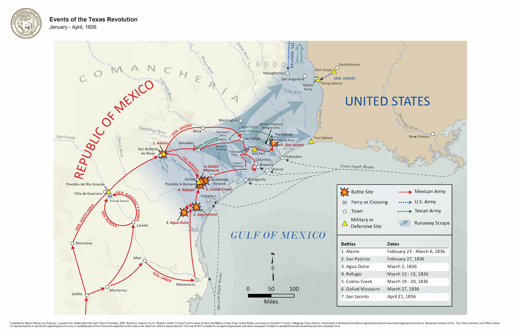
Events of the Texas Revolution
January - April, 1836
-
Map/Doc
97194
-
Collection
GIS Educational Maps
-
Object Dates
2023 (Creation Date)
-
People and Organizations
Ellyson Wong (Compiler)
Lila Rakoczy (Compiler)
Lynnette Cen (Compiler)
Kelsey Bonnell (Compiler)
Tomas Fernandez (Compiler)
-
Subjects
Mexican Texas Republic of Texas Geographic Information System Military
-
Height x Width
11.0 x 17.0 inches
27.9 x 43.2 cm
-
Medium
pdf
-
Comments
See 97188 and 97189 for related maps.
Related maps
Events of the Texas Revolution

Events of the Texas Revolution
2023
Size 8.5 x 11.0 inches
Map/Doc 97188
Events of the Texas Revolution

Events of the Texas Revolution
2023
Size 11.0 x 8.5 inches
Map/Doc 97189
Part of: GIS Educational Maps
American Civil War Political Loyalties

American Civil War Political Loyalties
2022
Size 8.5 x 11.0 inches
Map/Doc 97091

Primary Transportation Routes through Mexican Texas

Primary Transportation Routes through Mexican Texas
2024
Size 11.0 x 8.5 inches
Map/Doc 97463
United States Population Distribution by County and Territory, per the U.S. Census of 1880

United States Population Distribution by County and Territory, per the U.S. Census of 1880
2024
Size 8.5 x 11.0 inches
Map/Doc 97284

Yellow Fever Deaths in Texas and Louisiana

Yellow Fever Deaths in Texas and Louisiana
2022
Size 8.5 x 11.0 inches
Map/Doc 97094
Big Inch and Little Big Inch Pipelines

Big Inch and Little Big Inch Pipelines
2022
Size 8.5 x 11.0 inches
Map/Doc 97089
The Dust Bowl: Severe Drought During the Depression

The Dust Bowl: Severe Drought During the Depression
2022
Size 8.5 x 11.0 inches
Map/Doc 97095
Events of the Texas Revolution

Events of the Texas Revolution
2025
Size 8.5 x 11.0 inches
Map/Doc 97489
United States Population Distribution by County and Territory, per the U.S. Census of 1900

United States Population Distribution by County and Territory, per the U.S. Census of 1900
2025
Size 8.5 x 11.0 inches
Map/Doc 97481


You may also like
A Geographically Correct Map of the State of Texas

Print $20.00
- Digital $50.00
A Geographically Correct Map of the State of Texas
1876
Size 20.4 x 21.7 inches
Map/Doc 95361
Bastrop County

Print $40.00
- Digital $50.00
Bastrop County
1917
Size 48.0 x 40.5 inches
Map/Doc 4881
Foard County Working Sketch 9

Print $20.00
- Digital $50.00
Foard County Working Sketch 9
1977
Size 47.0 x 27.2 inches
Map/Doc 69200
Austin, State Capital of Texas

Digital $50.00
Austin, State Capital of Texas
1887
Size 23.0 x 32.1 inches
Map/Doc 90092
Zavala County Sketch File 11

Print $4.00
- Digital $50.00
Zavala County Sketch File 11
1885
Size 14.4 x 8.8 inches
Map/Doc 41270
Val Verde County Sketch File 44A

Print $10.00
- Digital $50.00
Val Verde County Sketch File 44A
1940
Size 14.5 x 8.8 inches
Map/Doc 39311
General Highway Map, Llano County, Texas

Print $20.00
General Highway Map, Llano County, Texas
1961
Size 18.2 x 24.6 inches
Map/Doc 79576
Map of Houston County

Print $40.00
- Digital $50.00
Map of Houston County
1841
Size 58.6 x 32.2 inches
Map/Doc 1952
Map of Callahan County, Texas

Print $20.00
- Digital $50.00
Map of Callahan County, Texas
1879
Size 24.6 x 19.6 inches
Map/Doc 4337
Camp County Working Sketch 2

Print $20.00
- Digital $50.00
Camp County Working Sketch 2
1975
Size 24.8 x 24.5 inches
Map/Doc 67878
Jefferson County Rolled Sketch 25

Print $20.00
- Digital $50.00
Jefferson County Rolled Sketch 25
1939
Size 43.4 x 36.0 inches
Map/Doc 9290
Atascosa County Rolled Sketch 15

Print $20.00
- Digital $50.00
Atascosa County Rolled Sketch 15
1945
Size 45.2 x 42.7 inches
Map/Doc 8433