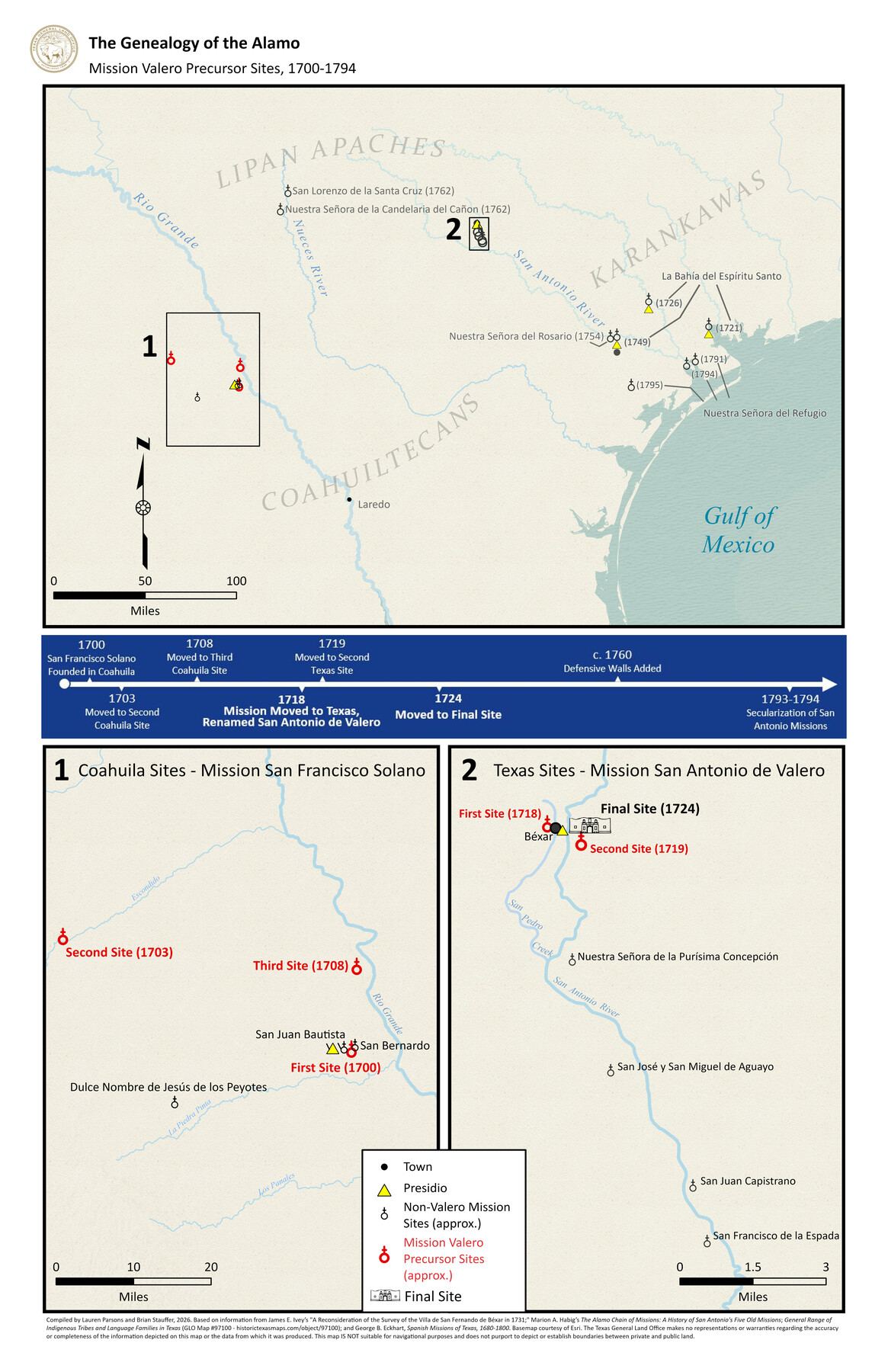
The Genealogy of the Alamo
Mission Valero Precursor Sites, 1700-1794
-
Map/Doc
97523
-
Collection
GIS Educational Maps
-
Object Dates
2026 (Creation Date)
-
People and Organizations
Lauren Parsons (Compiler)
Brian A. Stauffer (Compiler)
-
Subjects
Geographic Information System Spanish Texas
-
Height x Width
17.0 x 11.0 inches
43.2 x 27.9 cm
-
Medium
pdf
Part of: GIS Educational Maps
Military Reconstruction Districts

Military Reconstruction Districts
2024
Size 8.5 x 11.0 inches
Map/Doc 97345
The Buffalo Bayou, Brazos and Colorado Railroad (BBB&C)

The Buffalo Bayou, Brazos and Colorado Railroad (BBB&C)
2022
Size 8.5 x 11.0 inches
Map/Doc 97088

Events of the Texas Revolution

Events of the Texas Revolution
2023
Size 11.0 x 17.0 inches
Map/Doc 97194

United States Population Distribution by County and Territory, per the U.S. Census of 1870

United States Population Distribution by County and Territory, per the U.S. Census of 1870
2025
Size 8.5 x 11.0 inches
Map/Doc 97479

Texas Population Distribution in Cities, per the U.S. Census of 1910

Texas Population Distribution in Cities, per the U.S. Census of 1910
2022
Size 11.0 x 8.5 inches
Map/Doc 97092
General Range of Indigenous Tribes and Language Families in Texas

General Range of Indigenous Tribes and Language Families in Texas
2022
Size 8.5 x 11.0 inches
Map/Doc 97100
North American Territorial Claims and the Treaty of Paris

North American Territorial Claims and the Treaty of Paris
2025
Size 11.0 x 17.0 inches
Map/Doc 97453

Disputed Territory Between Mexico and the United States

Disputed Territory Between Mexico and the United States
2023
Size 11.0 x 8.5 inches
Map/Doc 97129
You may also like
Flight Mission No. CGI-3N, Frame 127, Cameron County

Print $20.00
- Digital $50.00
Flight Mission No. CGI-3N, Frame 127, Cameron County
1954
Size 18.8 x 22.4 inches
Map/Doc 84600
McMullen County Sketch File 39

Print $4.00
- Digital $50.00
McMullen County Sketch File 39
1938
Size 13.3 x 8.7 inches
Map/Doc 31413
Presidio County Rolled Sketch 6

Print $20.00
- Digital $50.00
Presidio County Rolled Sketch 6
Size 33.0 x 20.6 inches
Map/Doc 7330
Trinity County Sketch File 13

Print $6.00
- Digital $50.00
Trinity County Sketch File 13
1857
Size 5.0 x 6.3 inches
Map/Doc 38537
Capitol Syndicate Subdivision of Capitol Land Reservation Leagues Number 153, 154, 155, 156, 157, 158, 167, 168, 169, 170, 171, and 172 and Parts of Leagues 143, 144, 145, 146, 152, 159, 166, and 173

Print $20.00
- Digital $50.00
Capitol Syndicate Subdivision of Capitol Land Reservation Leagues Number 153, 154, 155, 156, 157, 158, 167, 168, 169, 170, 171, and 172 and Parts of Leagues 143, 144, 145, 146, 152, 159, 166, and 173
1908
Size 22.8 x 34.6 inches
Map/Doc 90735
Montague County Rolled Sketch 8

Print $20.00
- Digital $50.00
Montague County Rolled Sketch 8
Size 25.4 x 21.8 inches
Map/Doc 6792
Travis County Working Sketch 12

Print $20.00
- Digital $50.00
Travis County Working Sketch 12
1920
Size 47.8 x 26.1 inches
Map/Doc 69396
El Paso County Rolled Sketch 42

Print $20.00
- Digital $50.00
El Paso County Rolled Sketch 42
Size 34.5 x 24.5 inches
Map/Doc 5828
Carte d'un Nouveau Monde, entre le Nouveau Mexique, et la Mer Glacialle

Print $20.00
- Digital $50.00
Carte d'un Nouveau Monde, entre le Nouveau Mexique, et la Mer Glacialle
1698
Size 11.5 x 18.1 inches
Map/Doc 96555
Crane County Working Sketch 6

Print $40.00
- Digital $50.00
Crane County Working Sketch 6
1928
Size 92.2 x 25.3 inches
Map/Doc 68283

Nueces County Rolled Sketch 111

Print $20.00
- Digital $50.00
Nueces County Rolled Sketch 111
1991
Size 24.6 x 36.1 inches
Map/Doc 7119