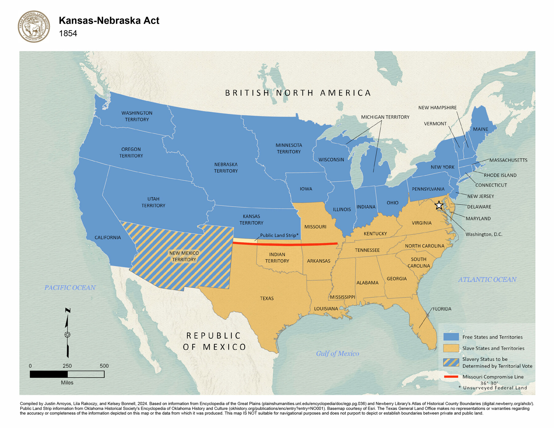
Kansas-Nebraska Act
1854
-
Map/Doc
97359
-
Collection
GIS Educational Maps
-
Object Dates
2024 (Creation Date)
-
People and Organizations
Justin Arroyos (Compiler)
Lila Rakoczy (Compiler)
Kelsey Bonnell (Compiler)
-
Subjects
Geographic Information System United States
-
Height x Width
8.5 x 11.0 inches
21.6 x 27.9 cm
-
Medium
pdf
-
Comments
See "Missouri Compromise of 1820" (97357) and “Compromise of 1850” (97358) for additional maps in this series.
Related maps


Part of: GIS Educational Maps

American Civil War Political Loyalties

American Civil War Political Loyalties
2022
Size 8.5 x 11.0 inches
Map/Doc 97091


Contracted Boundaries and Timeline of Mexican Empresario Colonies in Texas

Contracted Boundaries and Timeline of Mexican Empresario Colonies in Texas
2025
Size 17.0 x 11.0 inches
Map/Doc 97439
Events of the Texas Revolution

Events of the Texas Revolution
2023
Size 8.5 x 11.0 inches
Map/Doc 97188

Disputed Territory Between Mexico and the United States

Disputed Territory Between Mexico and the United States
2023
Size 11.0 x 8.5 inches
Map/Doc 97129
Primary Transportation Routes through Mexican Texas

Primary Transportation Routes through Mexican Texas
2024
Size 11.0 x 8.5 inches
Map/Doc 97463
United States Population Distribution by County and Territory, per the U.S. Census of 1890

United States Population Distribution by County and Territory, per the U.S. Census of 1890
2025
Size 8.5 x 11.0 inches
Map/Doc 97480
Map Showing the Distribution of the Slave Population of the Southern States of the United States

Map Showing the Distribution of the Slave Population of the Southern States of the United States
2022
Size 8.5 x 11.0 inches
Map/Doc 96677
You may also like

Webb County Sketch File 11-1

Print $8.00
- Digital $50.00
Webb County Sketch File 11-1
1884
Size 11.3 x 8.5 inches
Map/Doc 39781
Webb County Sketch File 14b

Print $4.00
- Digital $50.00
Webb County Sketch File 14b
1897
Size 11.2 x 8.8 inches
Map/Doc 39812
Kimble County Sketch File 31

Print $20.00
- Digital $50.00
Kimble County Sketch File 31
1890
Size 26.0 x 24.3 inches
Map/Doc 11929
Wharton County Boundary File 1b

Print $20.00
- Digital $50.00
Wharton County Boundary File 1b
Size 15.1 x 26.6 inches
Map/Doc 59855
Rand McNally Standard Map of Texas (reverse)

Print $20.00
Rand McNally Standard Map of Texas (reverse)
1923
Size 39.8 x 27.2 inches
Map/Doc 76229
The Judicial District/County of Lavaca. Created, January 29, 1842

Print $20.00
The Judicial District/County of Lavaca. Created, January 29, 1842
2020
Size 14.6 x 21.7 inches
Map/Doc 96331
Orange County Sketch File 44

Print $4.00
- Digital $50.00
Orange County Sketch File 44
1895
Size 10.9 x 8.8 inches
Map/Doc 33387
Carte des Côtes du Golfe du Mexique compris entre la Pointe Sud de la Presqu'Ile de la Floride et la Pointe Nord de la Presqu'Ile d'Yucatan

Print $20.00
- Digital $50.00
Carte des Côtes du Golfe du Mexique compris entre la Pointe Sud de la Presqu'Ile de la Floride et la Pointe Nord de la Presqu'Ile d'Yucatan
1800
Size 26.0 x 37.5 inches
Map/Doc 95322
Flight Mission No. DAH-17M, Frame 19, Orange County

Print $20.00
- Digital $50.00
Flight Mission No. DAH-17M, Frame 19, Orange County
1953
Size 18.6 x 22.6 inches
Map/Doc 86882
Dickens County Sketch File 19

Print $4.00
- Digital $50.00
Dickens County Sketch File 19
1910
Size 8.4 x 7.5 inches
Map/Doc 20982
Flight Mission No. BRA-6M, Frame 149, Jefferson County

Print $20.00
- Digital $50.00
Flight Mission No. BRA-6M, Frame 149, Jefferson County
1953
Size 18.5 x 22.3 inches
Map/Doc 85450