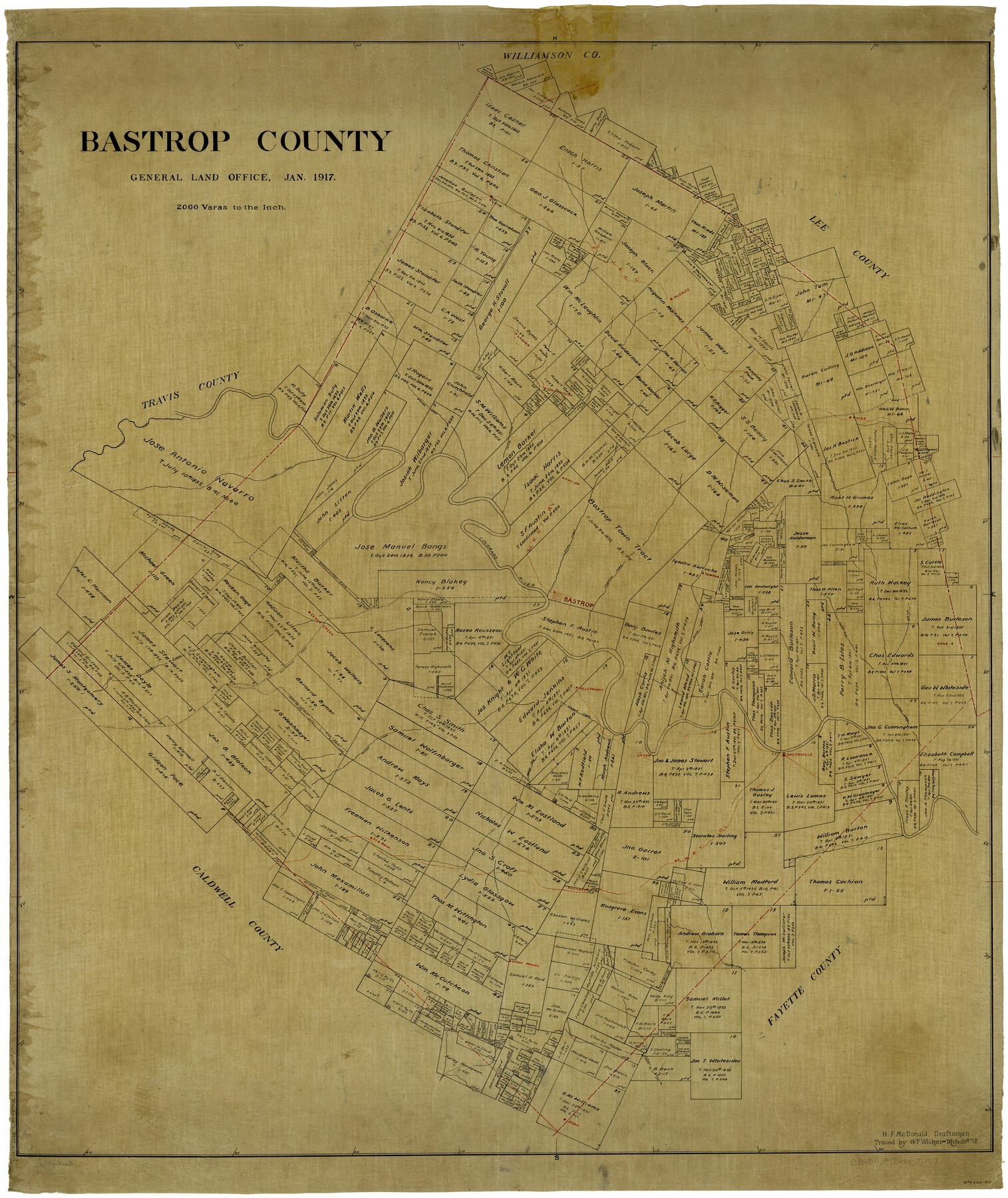
Bastrop County
-
Map/Doc
4881
-
Collection
General Map Collection
-
Object Dates
1/1917 (Creation Date)
-
People and Organizations
Texas General Land Office (Publisher)
H.M. McDonald (Compiler)
H.M. McDonald (Draftsman)
-
Counties
Bastrop
-
Subjects
County
-
Height x Width
48.0 x 40.5 inches
121.9 x 102.9 cm
-
Comments
Traced March 20, 1917 by G. T. Wicker.
Part of: General Map Collection
Flight Mission No. DQN-1K, Frame 45, Calhoun County

Print $20.00
- Digital $50.00
Flight Mission No. DQN-1K, Frame 45, Calhoun County
1953
Size 15.8 x 15.6 inches
Map/Doc 84145
Cherokee County Rolled Sketch 4

Print $20.00
- Digital $50.00
Cherokee County Rolled Sketch 4
1972
Size 30.7 x 23.6 inches
Map/Doc 5436
Duval County Working Sketch 46

Print $20.00
- Digital $50.00
Duval County Working Sketch 46
1980
Size 29.4 x 27.2 inches
Map/Doc 68770
Kent County Working Sketch 19

Print $40.00
- Digital $50.00
Kent County Working Sketch 19
1980
Size 36.8 x 51.5 inches
Map/Doc 70026
Gregg County Sketch File 1H

Print $2.00
- Digital $50.00
Gregg County Sketch File 1H
Size 5.8 x 5.4 inches
Map/Doc 24550
Eastland County Sketch File 18

Print $20.00
- Digital $50.00
Eastland County Sketch File 18
1912
Size 17.3 x 15.5 inches
Map/Doc 11414
Kendall County Rolled Sketch 5

Print $20.00
- Digital $50.00
Kendall County Rolled Sketch 5
Size 23.4 x 19.3 inches
Map/Doc 6458
Right of Way & Track Map, The Texas & Pacific Ry. Co. Main Line

Print $20.00
- Digital $50.00
Right of Way & Track Map, The Texas & Pacific Ry. Co. Main Line
Size 11.0 x 19.0 inches
Map/Doc 64685
Cameron County Sketch File 17

Print $24.00
- Digital $50.00
Cameron County Sketch File 17
2009
Size 11.0 x 8.5 inches
Map/Doc 95191
Flight Mission No. CLL-3N, Frame 3, Willacy County

Print $20.00
- Digital $50.00
Flight Mission No. CLL-3N, Frame 3, Willacy County
1954
Size 18.6 x 22.3 inches
Map/Doc 87069
Titus County Boundary File 4

Print $18.00
- Digital $50.00
Titus County Boundary File 4
Size 9.3 x 7.8 inches
Map/Doc 59303
Dickens County Sketch File E

Print $8.00
- Digital $50.00
Dickens County Sketch File E
Size 11.3 x 8.7 inches
Map/Doc 20843
You may also like
Flight Mission No. CUG-1P, Frame 161, Kleberg County

Print $20.00
- Digital $50.00
Flight Mission No. CUG-1P, Frame 161, Kleberg County
1956
Size 18.5 x 22.3 inches
Map/Doc 86168
Lavaca County

Print $40.00
- Digital $50.00
Lavaca County
1946
Size 51.1 x 42.8 inches
Map/Doc 73216
[Map showing S. A. & A. P. Ry. from San Antonio to Kendall County line]
![64255, [Map showing S. A. & A. P. Ry. from San Antonio to Kendall County line], General Map Collection](https://historictexasmaps.com/wmedia_w700/maps/64255.tif.jpg)
Print $40.00
- Digital $50.00
[Map showing S. A. & A. P. Ry. from San Antonio to Kendall County line]
1895
Size 25.5 x 70.7 inches
Map/Doc 64255
Pecos County Rolled Sketch 46

Print $3.00
- Digital $50.00
Pecos County Rolled Sketch 46
1913
Size 13.4 x 9.7 inches
Map/Doc 7224
Wilbarger County Working Sketch 20

Print $20.00
- Digital $50.00
Wilbarger County Working Sketch 20
1976
Size 27.4 x 43.4 inches
Map/Doc 72558
Edwards County Boundary File 27c

Print $29.00
- Digital $50.00
Edwards County Boundary File 27c
Size 12.8 x 8.1 inches
Map/Doc 52896
Motley County Boundary File 2d

Print $22.00
- Digital $50.00
Motley County Boundary File 2d
Size 14.3 x 8.7 inches
Map/Doc 57550
South Part Brewster Co.

Print $40.00
- Digital $50.00
South Part Brewster Co.
1915
Size 50.0 x 35.2 inches
Map/Doc 89723
Wilbarger County Sketch File 5a

Print $20.00
- Digital $50.00
Wilbarger County Sketch File 5a
Size 13.4 x 19.7 inches
Map/Doc 12690
Van Zandt County Rolled Sketch 5

Print $20.00
- Digital $50.00
Van Zandt County Rolled Sketch 5
1946
Size 27.1 x 28.1 inches
Map/Doc 8146
[Block M-23 and vicinity]
![91148, [Block M-23 and vicinity], Twichell Survey Records](https://historictexasmaps.com/wmedia_w700/maps/91148-1.tif.jpg)
Print $3.00
- Digital $50.00
[Block M-23 and vicinity]
Size 11.1 x 13.6 inches
Map/Doc 91148
