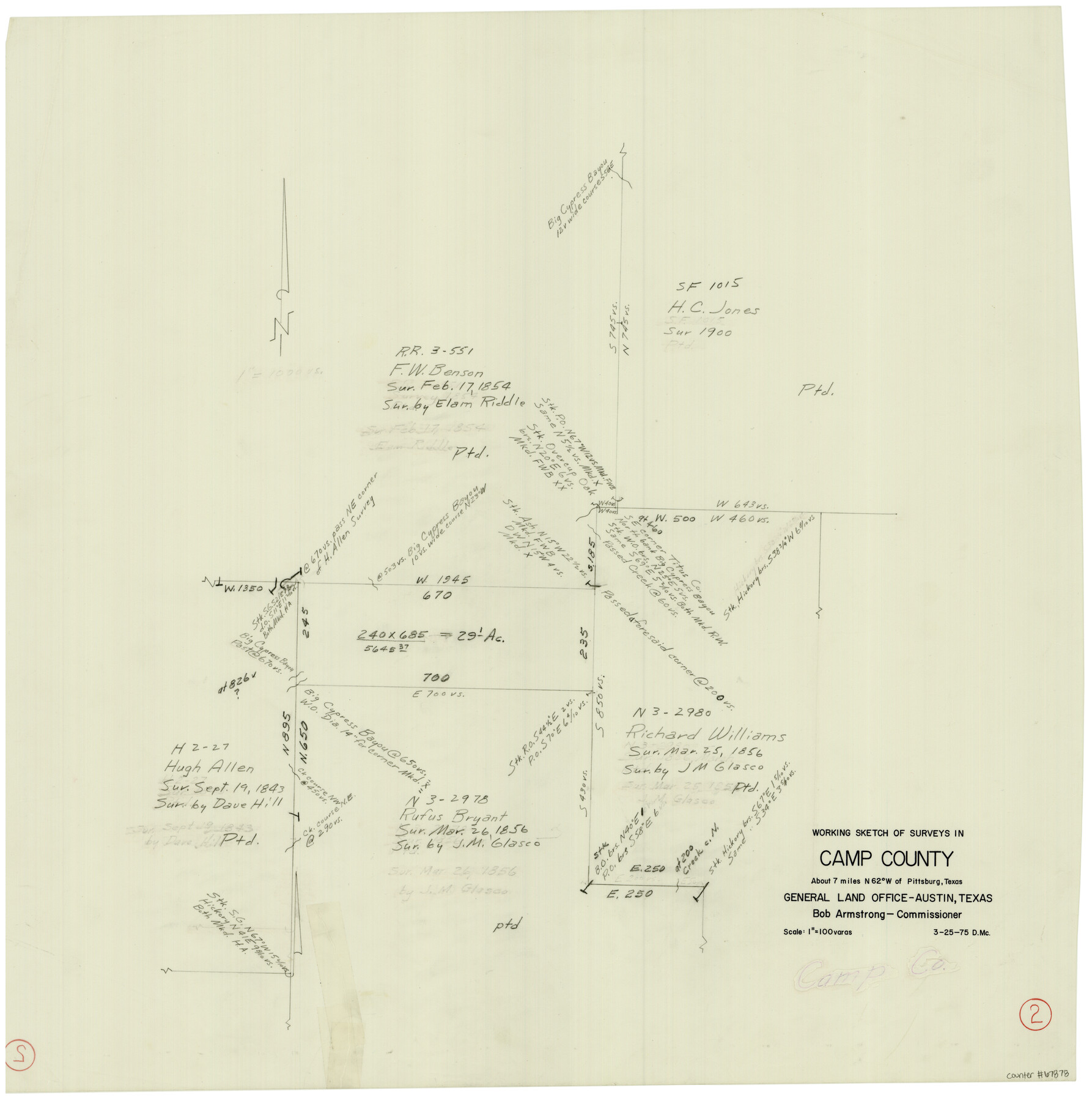
Camp County Working Sketch 2
-
Map/Doc
67878
-
Collection
General Map Collection
-
Object Dates
3/25/1975 (Creation Date)
-
Counties
Camp
-
Subjects
Surveying Working Sketch
-
Height x Width
24.8 x 24.5 inches
63.0 x 62.2 cm
-
Scale
1" = 100 varas
Part of: General Map Collection
Presidio County Rolled Sketch 21

Print $20.00
- Digital $50.00
Presidio County Rolled Sketch 21
1885
Size 35.5 x 42.8 inches
Map/Doc 9764
Karte von Indian Point od Indianola / Karte der Stadt Neu Braunfels / Karte der Stadt Friedrichsburg / Hafen von Indian Point oder Indianola

Print $20.00
- Digital $50.00
Karte von Indian Point od Indianola / Karte der Stadt Neu Braunfels / Karte der Stadt Friedrichsburg / Hafen von Indian Point oder Indianola
1850
Size 13.6 x 19.4 inches
Map/Doc 2182

Flight Mission No. DQO-11K, Frame 16, Galveston County

Print $20.00
- Digital $50.00
Flight Mission No. DQO-11K, Frame 16, Galveston County
1952
Size 18.8 x 22.5 inches
Map/Doc 85209
[Texas Gulf Coast from Rio Grande to Sabine Lake]
![72686, [Texas Gulf Coast from Rio Grande to Sabine Lake], General Map Collection](https://historictexasmaps.com/wmedia_w700/maps/72686.tif.jpg)
Print $20.00
- Digital $50.00
[Texas Gulf Coast from Rio Grande to Sabine Lake]
Size 28.0 x 18.3 inches
Map/Doc 72686
Gaines County Sketch File 4

Print $4.00
- Digital $50.00
Gaines County Sketch File 4
1902
Size 14.3 x 8.5 inches
Map/Doc 23175
Map of Clay Co.

Print $40.00
- Digital $50.00
Map of Clay Co.
1896
Size 51.9 x 31.0 inches
Map/Doc 4785
Crockett County Sketch File 10 and 11

Print $8.00
- Digital $50.00
Crockett County Sketch File 10 and 11
Size 12.6 x 7.3 inches
Map/Doc 19661

Presidio County Sketch File 21

Print $4.00
- Digital $50.00
Presidio County Sketch File 21
1889
Size 14.2 x 8.7 inches
Map/Doc 34454
Flight Mission No. CGI-2N, Frame 183, Cameron County

Print $20.00
- Digital $50.00
Flight Mission No. CGI-2N, Frame 183, Cameron County
1954
Size 18.7 x 22.2 inches
Map/Doc 84543
Dawson County

Print $20.00
- Digital $50.00
Dawson County
1959
Size 43.1 x 35.1 inches
Map/Doc 95476
You may also like
![88994, San Saba Co[unty], Library of Congress](https://historictexasmaps.com/wmedia_w700/maps/88994-1.tif.jpg)
Galveston County Rolled Sketch 29

Print $104.00
- Digital $50.00
Galveston County Rolled Sketch 29
Size 10.1 x 15.3 inches
Map/Doc 45147
Montague County Sketch File 15

Print $6.00
- Digital $50.00
Montague County Sketch File 15
1880
Size 11.0 x 15.1 inches
Map/Doc 31742
Flight Mission No. CRE-2R, Frame 155, Jackson County

Print $20.00
- Digital $50.00
Flight Mission No. CRE-2R, Frame 155, Jackson County
1956
Size 16.1 x 16.1 inches
Map/Doc 85366
Texas-Oklahoma (Indian Territory) Gainesville Quadrangle

Print $20.00
- Digital $50.00
Texas-Oklahoma (Indian Territory) Gainesville Quadrangle
1902
Size 21.2 x 17.2 inches
Map/Doc 75101
Presidio County Sketch File 42

Print $4.00
- Digital $50.00
Presidio County Sketch File 42
1913
Size 10.2 x 8.2 inches
Map/Doc 34518
Armstrong County, State of Texas

Print $20.00
- Digital $50.00
Armstrong County, State of Texas
1888
Size 22.6 x 18.2 inches
Map/Doc 3245
Presidio County Working Sketch 109

Print $20.00
- Digital $50.00
Presidio County Working Sketch 109
1980
Size 23.3 x 21.4 inches
Map/Doc 71786
Martha's Vineyard to Block Island Including Western Approach to Cape Cod Canal

Print $20.00
- Digital $50.00
Martha's Vineyard to Block Island Including Western Approach to Cape Cod Canal
1963
Size 51.1 x 36.9 inches
Map/Doc 73555
Bandera County Working Sketch 59

Print $20.00
- Digital $50.00
Bandera County Working Sketch 59
2003
Size 41.1 x 33.9 inches
Map/Doc 78346
[Cotton Belt, St. Louis Southwestern Railway of Texas, Alignment through Smith County]
![64383, [Cotton Belt, St. Louis Southwestern Railway of Texas, Alignment through Smith County], General Map Collection](https://historictexasmaps.com/wmedia_w700/maps/64383.tif.jpg)
Print $20.00
- Digital $50.00
[Cotton Belt, St. Louis Southwestern Railway of Texas, Alignment through Smith County]
1903
Size 21.5 x 29.4 inches
Map/Doc 64383
Galveston County Rolled Sketch 40A

Print $20.00
- Digital $50.00
Galveston County Rolled Sketch 40A
1988
Size 42.0 x 46.0 inches
Map/Doc 9020