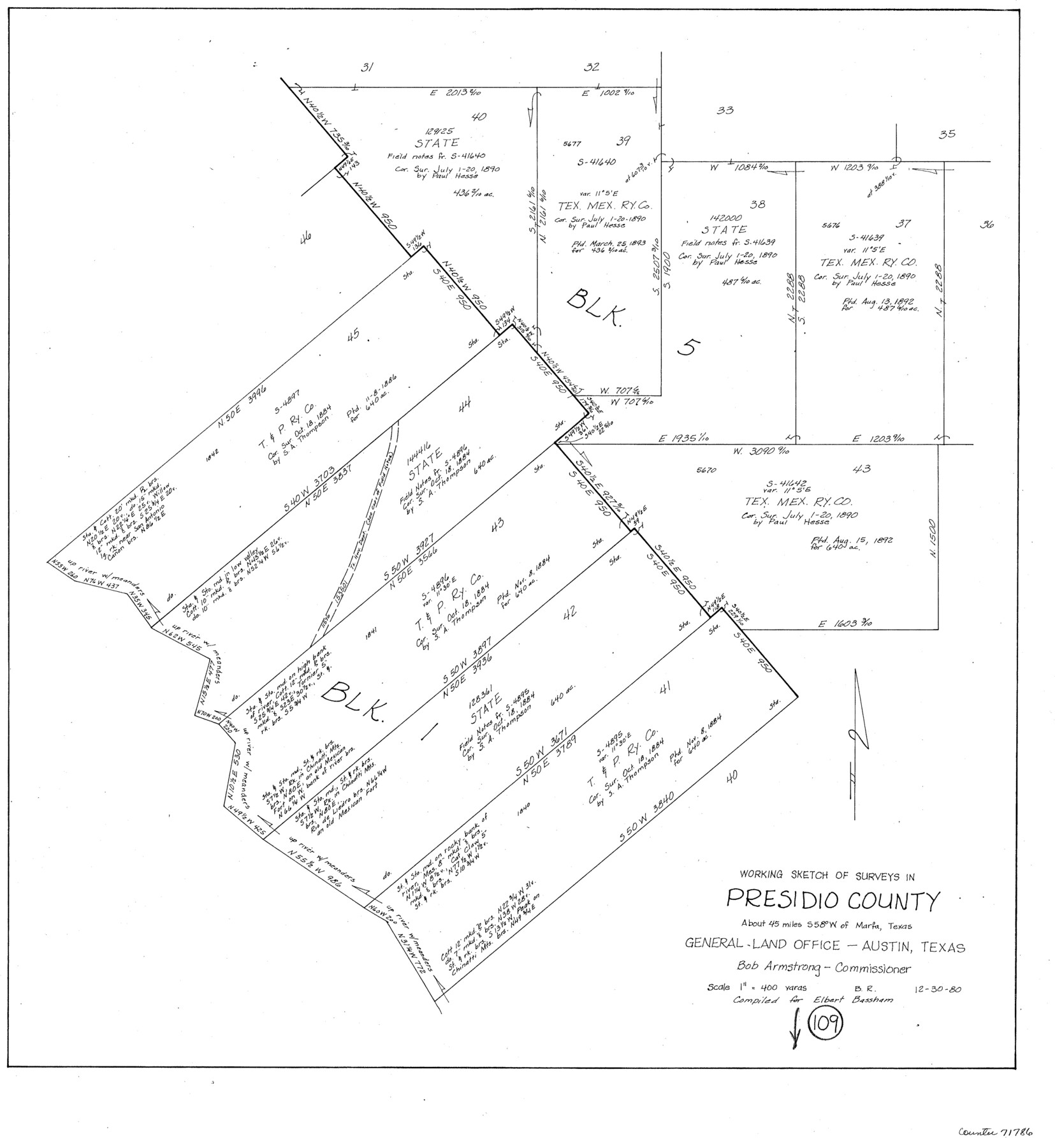
Presidio County Working Sketch 109
-
Map/Doc
71786
-
Collection
General Map Collection
-
Object Dates
12/30/1980 (Creation Date)
-
People and Organizations
Beverly Robison (Draftsman)
-
Counties
Presidio
-
Subjects
Surveying Working Sketch
-
Height x Width
23.3 x 21.4 inches
59.2 x 54.4 cm
-
Scale
1" = 400 varas
Part of: General Map Collection
Texas Official Highway Travel Map

Digital $50.00
Texas Official Highway Travel Map
Size 27.1 x 36.2 inches
Map/Doc 94311
Edwards County Boundary File 2

Print $28.00
- Digital $50.00
Edwards County Boundary File 2
Size 11.2 x 8.6 inches
Map/Doc 52862
Map of Panama, Texas

Print $5.00
- Digital $50.00
Map of Panama, Texas
1908
Size 10.4 x 15.6 inches
Map/Doc 94104
Harrison County Working Sketch 14

Print $20.00
- Digital $50.00
Harrison County Working Sketch 14
1961
Size 35.6 x 32.0 inches
Map/Doc 66034
South Part of Brewster Co.

Print $40.00
- Digital $50.00
South Part of Brewster Co.
1955
Size 48.8 x 40.0 inches
Map/Doc 66736
[Surveys along the Colorado River]
![49, [Surveys along the Colorado River], General Map Collection](https://historictexasmaps.com/wmedia_w700/maps/49.tif.jpg)
Print $20.00
- Digital $50.00
[Surveys along the Colorado River]
Size 28.6 x 24.0 inches
Map/Doc 49
Webb County Rolled Sketch 77

Print $20.00
- Digital $50.00
Webb County Rolled Sketch 77
1980
Size 39.1 x 38.5 inches
Map/Doc 10134
Flight Mission No. BQR-22K, Frame 38, Brazoria County

Print $20.00
- Digital $50.00
Flight Mission No. BQR-22K, Frame 38, Brazoria County
1953
Size 18.5 x 22.3 inches
Map/Doc 84122
Lamar County Working Sketch 10

Print $20.00
- Digital $50.00
Lamar County Working Sketch 10
1980
Size 18.6 x 15.4 inches
Map/Doc 70271
United States - Gulf Coast - Padre I. and Laguna Madre Lat. 27° 12' to Lat. 26° 33' Texas

Print $20.00
- Digital $50.00
United States - Gulf Coast - Padre I. and Laguna Madre Lat. 27° 12' to Lat. 26° 33' Texas
1913
Size 26.8 x 18.2 inches
Map/Doc 72815
Rains County Working Sketch 4

Print $20.00
- Digital $50.00
Rains County Working Sketch 4
1919
Size 27.3 x 25.9 inches
Map/Doc 71830
Traced from Genl. Arista's map captured by the American Army under Genl. Taylor at Resaca de la Palma 9th May '46 and presented to James K. Polk, President U. States

Print $20.00
- Digital $50.00
Traced from Genl. Arista's map captured by the American Army under Genl. Taylor at Resaca de la Palma 9th May '46 and presented to James K. Polk, President U. States
1846
Size 18.2 x 27.4 inches
Map/Doc 73061
You may also like
Flight Mission No. DQN-5K, Frame 74, Calhoun County

Print $20.00
- Digital $50.00
Flight Mission No. DQN-5K, Frame 74, Calhoun County
1953
Size 18.5 x 22.2 inches
Map/Doc 84407
Block No. 45 of the H. & T. C. R.R. Co. and Block No. 4T of the T. & N. O. R.R. Co. in Hansford and Ochiltree Cos. as resurveyed by J.L. Long, State Surveyor

Print $20.00
- Digital $50.00
Block No. 45 of the H. & T. C. R.R. Co. and Block No. 4T of the T. & N. O. R.R. Co. in Hansford and Ochiltree Cos. as resurveyed by J.L. Long, State Surveyor
1888
Size 34.1 x 28.1 inches
Map/Doc 75820
Bexar County Sketch File 33

Print $4.00
- Digital $50.00
Bexar County Sketch File 33
Size 10.7 x 8.5 inches
Map/Doc 14496
Gregg County Boundary File 7

Print $20.00
- Digital $50.00
Gregg County Boundary File 7
Size 5.2 x 8.6 inches
Map/Doc 54009
Flight Mission No. DQO-8K, Frame 70, Galveston County

Print $20.00
- Digital $50.00
Flight Mission No. DQO-8K, Frame 70, Galveston County
1952
Size 18.7 x 22.3 inches
Map/Doc 85174
Hall County Sketch File 25

Print $40.00
- Digital $50.00
Hall County Sketch File 25
1912
Size 14.5 x 13.6 inches
Map/Doc 24822
Flight Mission No. CRC-2R, Frame 64, Chambers County

Print $20.00
- Digital $50.00
Flight Mission No. CRC-2R, Frame 64, Chambers County
1956
Size 18.7 x 22.5 inches
Map/Doc 84735
Eastland County Working Sketch 19

Print $20.00
- Digital $50.00
Eastland County Working Sketch 19
1920
Size 15.7 x 16.4 inches
Map/Doc 68800
McClennan County Robertson District East of the Brazos Milam District West of the Brazos

Print $20.00
- Digital $50.00
McClennan County Robertson District East of the Brazos Milam District West of the Brazos
1878
Size 21.0 x 23.4 inches
Map/Doc 3865
Hidalgo County Working Sketch 8

Print $40.00
- Digital $50.00
Hidalgo County Working Sketch 8
1963
Size 25.7 x 72.8 inches
Map/Doc 66185
Donley County Sketch File 18 (2a)

Print $2.00
- Digital $50.00
Donley County Sketch File 18 (2a)
Size 10.3 x 8.0 inches
Map/Doc 21255
Flight Mission No. BRE-1P, Frame 103, Nueces County

Print $20.00
- Digital $50.00
Flight Mission No. BRE-1P, Frame 103, Nueces County
1956
Size 18.4 x 22.2 inches
Map/Doc 86674