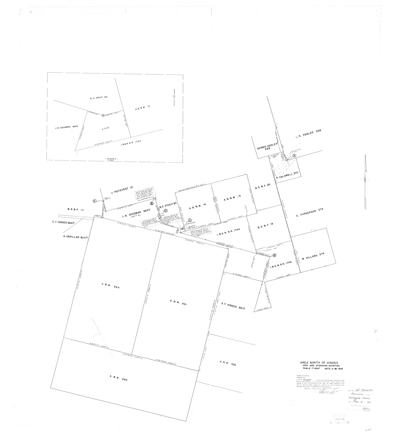
Atascosa County Rolled Sketch 15
Area north of Hindes, Frio and Atascosa Counties
-
Map/Doc
8433
-
Collection
General Map Collection
-
Object Dates
1945/3/26 (Creation Date)
1946/2/4 (File Date)
-
People and Organizations
F.T. Drought (Surveyor/Engineer)
-
Counties
Atascosa Frio
-
Subjects
Surveying Rolled Sketch
-
Height x Width
45.2 x 42.7 inches
114.8 x 108.5 cm
-
Medium
blueprint/diazo
-
Scale
1" = 500 varas
Part of: General Map Collection
Castro County Rolled Sketch 7

Print $20.00
- Digital $50.00
Castro County Rolled Sketch 7
1908
Size 28.9 x 24.1 inches
Map/Doc 5417
Montgomery County Rolled Sketch 48

Print $20.00
- Digital $50.00
Montgomery County Rolled Sketch 48
2007
Size 11.2 x 17.2 inches
Map/Doc 89278
Gregg County Rolled Sketch 9

Print $20.00
- Digital $50.00
Gregg County Rolled Sketch 9
1933
Size 38.0 x 29.8 inches
Map/Doc 6034
Erath County Sketch File 5

Print $8.00
- Digital $50.00
Erath County Sketch File 5
Size 13.0 x 8.4 inches
Map/Doc 22263
Harris County Rolled Sketch 88

Print $20.00
- Digital $50.00
Harris County Rolled Sketch 88
1935
Size 19.2 x 22.5 inches
Map/Doc 6123
Dickens County Rolled Sketch 5

Print $40.00
- Digital $50.00
Dickens County Rolled Sketch 5
1947
Size 60.2 x 40.3 inches
Map/Doc 8787
Kleberg County Rolled Sketch 10-29

Print $20.00
- Digital $50.00
Kleberg County Rolled Sketch 10-29
1952
Size 37.6 x 33.8 inches
Map/Doc 9373
Newton County Rolled Sketch 19

Print $20.00
- Digital $50.00
Newton County Rolled Sketch 19
1956
Size 42.1 x 33.5 inches
Map/Doc 6848
Harrison County Sketch File 20

Print $20.00
- Digital $50.00
Harrison County Sketch File 20
1946
Size 26.4 x 21.8 inches
Map/Doc 11693
Stonewall County Rolled Sketch 35

Print $20.00
- Digital $50.00
Stonewall County Rolled Sketch 35
1983
Size 42.7 x 34.5 inches
Map/Doc 9971
Jasper County

Print $20.00
- Digital $50.00
Jasper County
1946
Size 46.8 x 41.0 inches
Map/Doc 77325
[Map to illustrate possible mineral resources on the lands belonging to the University of Texas]
![62963, [Map to illustrate possible mineral resources on the lands belonging to the University of Texas], General Map Collection](https://historictexasmaps.com/wmedia_w700/maps/62963.tif.jpg)
Print $2.00
- Digital $50.00
[Map to illustrate possible mineral resources on the lands belonging to the University of Texas]
Size 10.2 x 7.7 inches
Map/Doc 62963
You may also like
Gulf Oil Corp. Fishgide - Port O'Connor

Gulf Oil Corp. Fishgide - Port O'Connor
1960
Size 12.2 x 22.3 inches
Map/Doc 75983
Dimmit County Sketch File 55

Print $20.00
- Digital $50.00
Dimmit County Sketch File 55
1926
Size 23.1 x 15.7 inches
Map/Doc 11359

Newton County Rolled Sketch 22

Print $20.00
- Digital $50.00
Newton County Rolled Sketch 22
1957
Size 20.8 x 28.7 inches
Map/Doc 6849
Ector County Working Sketch 7

Print $40.00
- Digital $50.00
Ector County Working Sketch 7
1941
Size 48.5 x 29.3 inches
Map/Doc 68850
Abernathy Quadrangle

Print $20.00
- Digital $50.00
Abernathy Quadrangle
Size 17.6 x 21.4 inches
Map/Doc 92813
Harris County Sketch File 64

Print $40.00
- Digital $50.00
Harris County Sketch File 64
Size 16.3 x 14.1 inches
Map/Doc 25503
[T. & P. Blocks 33 and 34, Township 5N]
![90553, [T. & P. Blocks 33 and 34, Township 5N], Twichell Survey Records](https://historictexasmaps.com/wmedia_w700/maps/90553-1.tif.jpg)
Print $20.00
- Digital $50.00
[T. & P. Blocks 33 and 34, Township 5N]
Size 17.4 x 12.0 inches
Map/Doc 90553
Sutton County Working Sketch 66

Print $20.00
- Digital $50.00
Sutton County Working Sketch 66
1972
Size 29.0 x 39.3 inches
Map/Doc 62409
Yoakum County Rolled Sketch 5

Print $20.00
- Digital $50.00
Yoakum County Rolled Sketch 5
1992
Size 20.9 x 16.3 inches
Map/Doc 8290
Baker Addition to Lamesa, Part of Southwest Quarter Section 71, Block 35

Print $20.00
- Digital $50.00
Baker Addition to Lamesa, Part of Southwest Quarter Section 71, Block 35
Size 23.8 x 19.5 inches
Map/Doc 92576
College Park Addition to the City of Lubbock Located on Section 9, Block B

Print $20.00
- Digital $50.00
College Park Addition to the City of Lubbock Located on Section 9, Block B
Size 12.9 x 15.9 inches
Map/Doc 92277