Harris County Rolled Sketch 88
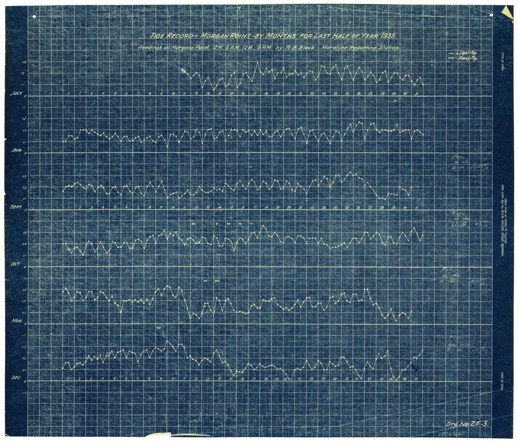
Tide Record - Morgan Point - by months for last half of year 1935 - Readings at Morgan's Point 12 M., 6 A.M., 12 M., 6 P. M.
-
Map/Doc
6123
-
Collection
General Map Collection
-
Object Dates
1935 (Creation Date)
-
People and Organizations
W.B. Black (Surveyor/Engineer)
-
Counties
Harris
-
Subjects
Surveying Rolled Sketch
-
Height x Width
19.2 x 22.5 inches
48.8 x 57.2 cm
-
Medium
blueprint/diazo
Part of: General Map Collection
Shackelford County Sketch File 10

Print $20.00
- Digital $50.00
Shackelford County Sketch File 10
1918
Size 31.4 x 19.9 inches
Map/Doc 12316
Grayson County Working Sketch 16

Print $20.00
- Digital $50.00
Grayson County Working Sketch 16
1954
Size 44.2 x 24.7 inches
Map/Doc 63255
Burnet County Working Sketch Graphic Index

Print $20.00
- Digital $50.00
Burnet County Working Sketch Graphic Index
1924
Size 46.5 x 41.2 inches
Map/Doc 76482
Hudspeth County Sketch File 44

Print $6.00
- Digital $50.00
Hudspeth County Sketch File 44
1886
Size 11.0 x 8.5 inches
Map/Doc 27027
Jackson County

Print $20.00
- Digital $50.00
Jackson County
1920
Size 45.9 x 39.1 inches
Map/Doc 73191
Hamilton County Working Sketch 15

Print $40.00
- Digital $50.00
Hamilton County Working Sketch 15
1949
Size 54.5 x 37.6 inches
Map/Doc 63353
Matagorda County Working Sketch 33

Print $20.00
- Digital $50.00
Matagorda County Working Sketch 33
1998
Size 32.0 x 42.5 inches
Map/Doc 70891

Hood County Working Sketch 20

Print $20.00
- Digital $50.00
Hood County Working Sketch 20
1989
Size 39.6 x 34.7 inches
Map/Doc 66214
Lee County Working Sketch 15

Print $20.00
- Digital $50.00
Lee County Working Sketch 15
1981
Size 18.4 x 14.0 inches
Map/Doc 70394
Galveston Bay, Texas

Print $20.00
- Digital $50.00
Galveston Bay, Texas
1905
Size 22.1 x 18.5 inches
Map/Doc 65389
Flight Mission No. CRE-2R, Frame 172, Jackson County

Print $20.00
- Digital $50.00
Flight Mission No. CRE-2R, Frame 172, Jackson County
1956
Size 18.5 x 22.2 inches
Map/Doc 85382
You may also like
[C. C. S. D. & R. G. N. G. RR. Co. Block G, Waxahachie Tap RR. Co. Block G and D. & W. RR. Co. Block H]
![90859, [C. C. S. D. & R. G. N. G. RR. Co. Block G, Waxahachie Tap RR. Co. Block G and D. & W. RR. Co. Block H], Twichell Survey Records](https://historictexasmaps.com/wmedia_w700/maps/90859-2.tif.jpg)
Print $20.00
- Digital $50.00
[C. C. S. D. & R. G. N. G. RR. Co. Block G, Waxahachie Tap RR. Co. Block G and D. & W. RR. Co. Block H]
1915
Size 22.6 x 11.4 inches
Map/Doc 90859
Moore County Rolled Sketch 13

Print $20.00
- Digital $50.00
Moore County Rolled Sketch 13
1920
Size 25.8 x 33.3 inches
Map/Doc 6829
Flight Mission No. CGI-2N, Frame 153, Cameron County

Print $20.00
- Digital $50.00
Flight Mission No. CGI-2N, Frame 153, Cameron County
1954
Size 18.8 x 22.3 inches
Map/Doc 84535
Calhoun County Sketch File 10

Print $11.00
- Digital $50.00
Calhoun County Sketch File 10
1956
Size 14.3 x 8.8 inches
Map/Doc 35940
General Topographical Map. Sheet XXII

Print $20.00
- Digital $50.00
General Topographical Map. Sheet XXII
1891
Size 18.4 x 29.4 inches
Map/Doc 97526
La Salle County Rolled Sketch 24

Print $20.00
- Digital $50.00
La Salle County Rolled Sketch 24
1955
Size 36.7 x 39.4 inches
Map/Doc 10655
Reeves County Boundary File 1

Print $12.00
- Digital $50.00
Reeves County Boundary File 1
Size 14.1 x 8.5 inches
Map/Doc 58195
[Roosevelt, Quay, and other Counties, N.M.]
![89820, [Roosevelt, Quay, and other Counties, N.M.], Twichell Survey Records](https://historictexasmaps.com/wmedia_w700/maps/89820-1.tif.jpg)
Print $40.00
- Digital $50.00
[Roosevelt, Quay, and other Counties, N.M.]
Size 40.7 x 57.6 inches
Map/Doc 89820
General Highway Map, Schleicher County, Sutton County, Texas

Print $20.00
General Highway Map, Schleicher County, Sutton County, Texas
1940
Size 18.3 x 25.0 inches
Map/Doc 79239
Chambers County NRC Article 33.136 Sketch 4

Print $48.00
- Digital $50.00
Chambers County NRC Article 33.136 Sketch 4
2003
Size 18.2 x 24.3 inches
Map/Doc 78569
Brewster County Working Sketch 71a

Print $40.00
- Digital $50.00
Brewster County Working Sketch 71a
1962
Size 43.5 x 56.0 inches
Map/Doc 67869
Chocolate Bay, West Portion of West Bay and Vicinity, Brazoria and Galveston Counties, showing Subdivision for Mineral Development

Print $40.00
- Digital $50.00
Chocolate Bay, West Portion of West Bay and Vicinity, Brazoria and Galveston Counties, showing Subdivision for Mineral Development
1948
Size 40.7 x 53.9 inches
Map/Doc 1907