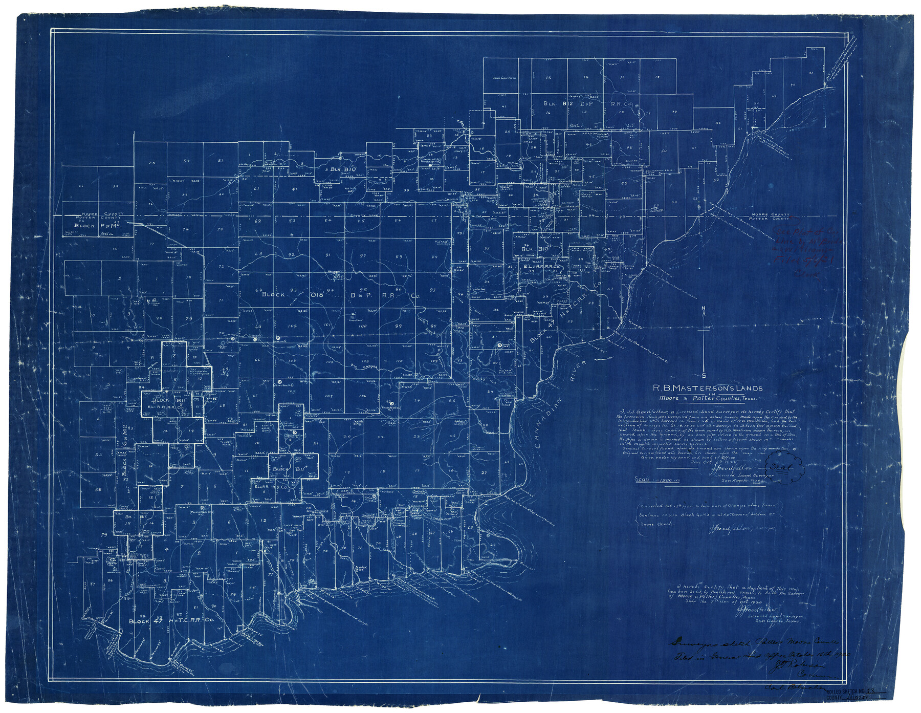
Moore County Rolled Sketch 13
R.B. Masterson's lands in Moore & Potter Counties, Texas
-
Map/Doc
6829
-
Collection
General Map Collection
-
Object Dates
10/6/1920 (Creation Date)
10/16/1920 (File Date)
10/15/1920 (Revision Date)
-
People and Organizations
J.J. Goodfellow (Surveyor/Engineer)
-
Counties
Moore Potter
-
Subjects
Surveying Rolled Sketch
-
Height x Width
25.8 x 33.3 inches
65.5 x 84.6 cm
-
Medium
blueprint/diazo
-
Scale
1" = 1500 varas
Part of: General Map Collection
McCulloch County Boundary File 1

Print $40.00
- Digital $50.00
McCulloch County Boundary File 1
Size 9.2 x 33.6 inches
Map/Doc 56906
Cottle County Working Sketch 24

Print $20.00
- Digital $50.00
Cottle County Working Sketch 24
2014
Size 10.6 x 18.3 inches
Map/Doc 93707
Tom Green County Sketch File 2

Print $4.00
- Digital $50.00
Tom Green County Sketch File 2
Size 9.6 x 7.6 inches
Map/Doc 38161
Brewster County Rolled Sketch 74

Print $20.00
- Digital $50.00
Brewster County Rolled Sketch 74
1941
Size 22.8 x 15.8 inches
Map/Doc 5240
Kerr County Boundary File 4c

Print $4.00
- Digital $50.00
Kerr County Boundary File 4c
Size 3.7 x 12.3 inches
Map/Doc 64816
Webb County Working Sketch 14

Print $20.00
- Digital $50.00
Webb County Working Sketch 14
1923
Size 19.3 x 32.2 inches
Map/Doc 72379
Map of Randall County

Print $20.00
- Digital $50.00
Map of Randall County
1892
Size 24.4 x 18.6 inches
Map/Doc 3975
Panola County Working Sketch 23

Print $20.00
- Digital $50.00
Panola County Working Sketch 23
1951
Map/Doc 71432
Williamson County Sketch File 5a

Print $4.00
- Digital $50.00
Williamson County Sketch File 5a
1849
Size 12.8 x 8.1 inches
Map/Doc 40312
Zavala County Sketch File 5

Print $4.00
- Digital $50.00
Zavala County Sketch File 5
1876
Size 13.0 x 8.4 inches
Map/Doc 41263
Pecos County Sketch File 22

Print $20.00
- Digital $50.00
Pecos County Sketch File 22
1886
Size 14.0 x 8.8 inches
Map/Doc 33670
Carta Politica

Print $20.00
- Digital $50.00
Carta Politica
1897
Size 26.2 x 34.1 inches
Map/Doc 96797
You may also like
Webb County Sketch File 61

Print $6.00
- Digital $50.00
Webb County Sketch File 61
1944
Size 14.5 x 8.8 inches
Map/Doc 39859
Map of Texas, compiled from surveys on record in the General Land Office of the Republic

Print $20.00
Map of Texas, compiled from surveys on record in the General Land Office of the Republic
1847
Size 32.2 x 25.0 inches
Map/Doc 79325
Hutchinson County Sketch File 40

Print $32.00
- Digital $50.00
Hutchinson County Sketch File 40
Size 11.3 x 8.9 inches
Map/Doc 27282
Fifteenth Census 1930 Population - Texas

Print $20.00
- Digital $50.00
Fifteenth Census 1930 Population - Texas
1930
Size 19.5 x 22.6 inches
Map/Doc 2146
L'Amerique Meridionale, et Septentrionale Dressee selon les derniers Relations et suivant les Nouvelles Decouvertes

Print $20.00
- Digital $50.00
L'Amerique Meridionale, et Septentrionale Dressee selon les derniers Relations et suivant les Nouvelles Decouvertes
1726
Size 18.9 x 24.1 inches
Map/Doc 95134
Map of Matagorda County

Print $20.00
- Digital $50.00
Map of Matagorda County
1839
Size 23.5 x 32.2 inches
Map/Doc 3844
Flight Mission No. CGI-3N, Frame 121, Cameron County

Print $20.00
- Digital $50.00
Flight Mission No. CGI-3N, Frame 121, Cameron County
1954
Size 18.5 x 22.3 inches
Map/Doc 84594
Lamar County State Real Property Sketch 1

Print $20.00
- Digital $50.00
Lamar County State Real Property Sketch 1
2013
Size 24.0 x 36.0 inches
Map/Doc 93658
Val Verde Co.

Print $20.00
- Digital $50.00
Val Verde Co.
1908
Size 42.4 x 38.7 inches
Map/Doc 16912
Water-Shed of the Sulphur River in Texas Drainage Area

Print $4.00
- Digital $50.00
Water-Shed of the Sulphur River in Texas Drainage Area
1925
Size 16.6 x 28.4 inches
Map/Doc 65154

McLennan County Boundary File 6

Print $16.00
- Digital $50.00
McLennan County Boundary File 6
Size 11.1 x 8.6 inches
Map/Doc 56997