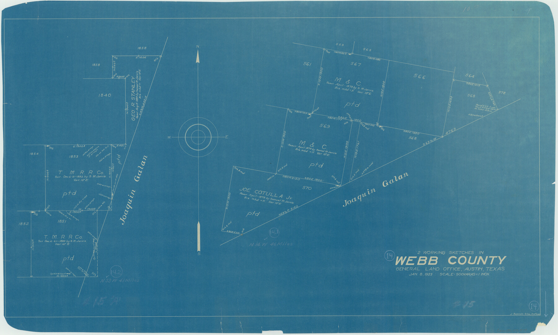
Webb County Working Sketch 14
-
Map/Doc
72379
-
Collection
General Map Collection
-
Object Dates
1/8/1923 (Creation Date)
-
People and Organizations
J. Bascom Giles (Draftsman)
-
Counties
Webb
-
Subjects
Surveying Working Sketch
-
Height x Width
19.3 x 32.2 inches
49.0 x 81.8 cm
-
Scale
1" = 500 varas
Part of: General Map Collection
Presidio County Working Sketch 80

Print $20.00
- Digital $50.00
Presidio County Working Sketch 80
1967
Size 18.8 x 30.5 inches
Map/Doc 71757
Oldham County Working Sketch 3

Print $20.00
- Digital $50.00
Oldham County Working Sketch 3
1946
Size 26.2 x 19.3 inches
Map/Doc 71325
Young County Rolled Sketch 8

Print $20.00
- Digital $50.00
Young County Rolled Sketch 8
Size 40.5 x 25.8 inches
Map/Doc 8296
Upton County Sketch File 24

Print $4.00
- Digital $50.00
Upton County Sketch File 24
1928
Size 11.3 x 8.8 inches
Map/Doc 38879
Bastrop County Working Sketch 10

Print $20.00
- Digital $50.00
Bastrop County Working Sketch 10
1968
Size 31.9 x 37.7 inches
Map/Doc 67310
Clay County Sketch File 20

Print $8.00
- Digital $50.00
Clay County Sketch File 20
1882
Size 11.2 x 8.6 inches
Map/Doc 18431
Jefferson County Sketch File 37

Print $20.00
- Digital $50.00
Jefferson County Sketch File 37
Size 22.3 x 32.4 inches
Map/Doc 11875
Flight Mission No. DQN-7K, Frame 95, Calhoun County

Print $20.00
- Digital $50.00
Flight Mission No. DQN-7K, Frame 95, Calhoun County
1953
Size 18.6 x 22.1 inches
Map/Doc 84486
Pecos County Rolled Sketch 28

Print $20.00
- Digital $50.00
Pecos County Rolled Sketch 28
1890
Size 18.9 x 38.5 inches
Map/Doc 7213
Map of Tom Green County

Print $40.00
- Digital $50.00
Map of Tom Green County
1892
Size 42.9 x 48.2 inches
Map/Doc 63069
Hemphill County Rolled Sketch 17

Print $20.00
- Digital $50.00
Hemphill County Rolled Sketch 17
1965
Size 29.2 x 40.1 inches
Map/Doc 6198

You may also like
Sherman County

Print $20.00
- Digital $50.00
Sherman County
1932
Size 38.7 x 36.3 inches
Map/Doc 73289
Maps showing Arkansas Central, the Helena & Corinth, and the Pine Bluff & Southwestern Railroads together forming the Texas & Northeastern Railway.

Print $20.00
Maps showing Arkansas Central, the Helena & Corinth, and the Pine Bluff & Southwestern Railroads together forming the Texas & Northeastern Railway.
1872
Size 26.8 x 29.1 inches
Map/Doc 93609
Flight Mission No. CUG-2P, Frame 9, Kleberg County

Print $20.00
- Digital $50.00
Flight Mission No. CUG-2P, Frame 9, Kleberg County
1956
Size 18.6 x 22.2 inches
Map/Doc 86181
Comanche County Working Sketch 19

Print $20.00
- Digital $50.00
Comanche County Working Sketch 19
1973
Size 28.9 x 40.3 inches
Map/Doc 68153
The Mexican Department of Brazos. Created, March 18, 1834

Print $20.00
The Mexican Department of Brazos. Created, March 18, 1834
2020
Size 19.7 x 21.7 inches
Map/Doc 95975
[Surveys in Austin's Colony along the west bank of the Colorado River]
![199, [Surveys in Austin's Colony along the west bank of the Colorado River], General Map Collection](https://historictexasmaps.com/wmedia_w700/maps/199.tif.jpg)
Print $20.00
- Digital $50.00
[Surveys in Austin's Colony along the west bank of the Colorado River]
1831
Size 10.9 x 28.5 inches
Map/Doc 199
General Highway Map, Duval County, Texas

Print $20.00
General Highway Map, Duval County, Texas
1961
Size 18.1 x 24.5 inches
Map/Doc 79449
Crockett County Working Sketch 84

Print $40.00
- Digital $50.00
Crockett County Working Sketch 84
1976
Size 49.4 x 26.2 inches
Map/Doc 68417
Upshur County Working Sketch 8

Print $20.00
- Digital $50.00
Upshur County Working Sketch 8
1960
Size 29.5 x 26.7 inches
Map/Doc 69564
"K" Sketch from Loving & Winkler Counties

Print $40.00
- Digital $50.00
"K" Sketch from Loving & Winkler Counties
1902
Size 49.4 x 39.7 inches
Map/Doc 89938

Harris County Sketch File 58

Print $20.00
- Digital $50.00
Harris County Sketch File 58
1920
Size 27.6 x 21.4 inches
Map/Doc 11657