Clay County Sketch File 20
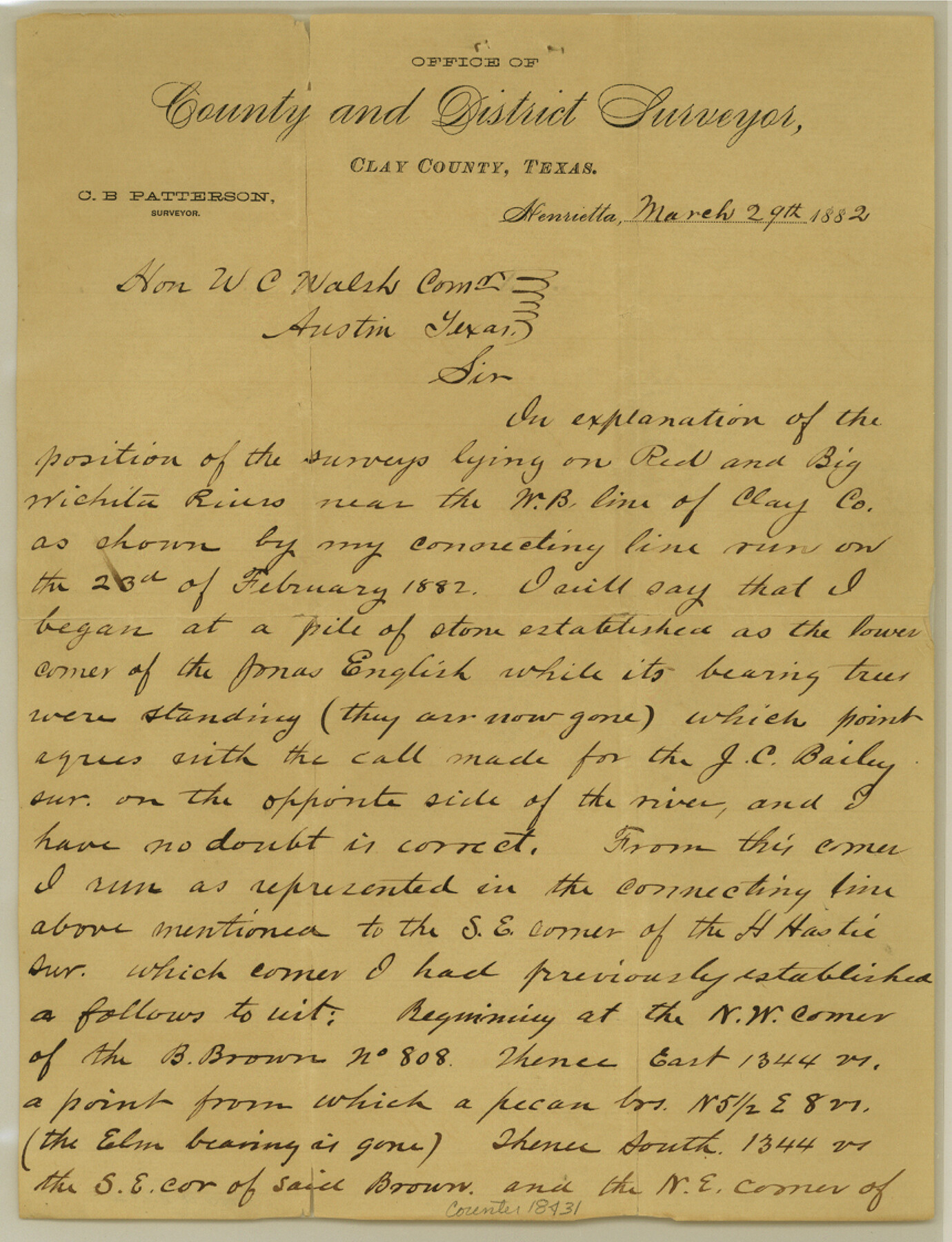
[Explanation regarding the position of surveys lying on Red River and Big Wichita River near the west boundary line of Clay County]
-
Map/Doc
18431
-
Collection
General Map Collection
-
Object Dates
1882/3/29 (Creation Date)
1882/4/4 (File Date)
-
People and Organizations
C.B. Patterson (Surveyor/Engineer)
-
Counties
Wichita Clay
-
Subjects
Surveying Sketch File
-
Height x Width
11.2 x 8.6 inches
28.4 x 21.8 cm
-
Medium
paper, manuscript
-
Features
Red River
Big Wichita River
Part of: General Map Collection
Navigation Maps of Gulf Intracoastal Waterway, Port Arthur to Brownsville, Texas

Print $4.00
- Digital $50.00
Navigation Maps of Gulf Intracoastal Waterway, Port Arthur to Brownsville, Texas
1951
Size 16.6 x 21.2 inches
Map/Doc 65445
Williamson County

Print $40.00
- Digital $50.00
Williamson County
1946
Size 39.0 x 56.3 inches
Map/Doc 73326
Flight Mission No. CLL-4N, Frame 36, Willacy County

Print $20.00
- Digital $50.00
Flight Mission No. CLL-4N, Frame 36, Willacy County
1954
Size 18.4 x 22.1 inches
Map/Doc 87109
Nueces County Sketch File 64

Print $10.00
- Digital $50.00
Nueces County Sketch File 64
1979
Size 11.2 x 8.6 inches
Map/Doc 32975
Harris County Sketch File 28

Print $14.00
- Digital $50.00
Harris County Sketch File 28
1886
Size 12.7 x 8.2 inches
Map/Doc 25402
Liberty County Sketch File 11

Print $6.00
- Digital $50.00
Liberty County Sketch File 11
1858
Size 11.8 x 10.0 inches
Map/Doc 29905
Crockett County Rolled Sketch 61

Print $20.00
- Digital $50.00
Crockett County Rolled Sketch 61
Size 12.7 x 20.9 inches
Map/Doc 5604
Map of City of Lampasas, Texas

Print $20.00
- Digital $50.00
Map of City of Lampasas, Texas
1935
Size 26.1 x 17.6 inches
Map/Doc 4827
Angelina County Working Sketch 47

Print $20.00
- Digital $50.00
Angelina County Working Sketch 47
1976
Size 36.9 x 41.9 inches
Map/Doc 67130

Dallas County Boundary File 6e

Print $70.00
- Digital $50.00
Dallas County Boundary File 6e
Size 16.6 x 22.5 inches
Map/Doc 52254
Matagorda County Sketch File 35

Print $8.00
- Digital $50.00
Matagorda County Sketch File 35
1951
Size 11.1 x 8.8 inches
Map/Doc 30823
You may also like
Hardin County Working Sketch 44

Print $40.00
- Digital $50.00
Hardin County Working Sketch 44
1954
Size 53.2 x 39.9 inches
Map/Doc 65610
Pecos County Sketch File 113

Print $10.00
- Digital $50.00
Pecos County Sketch File 113
Size 11.3 x 8.7 inches
Map/Doc 34069
English Field Notes of the Spanish Archives - Books DBE, WBPS, GAN, WB3, and X

English Field Notes of the Spanish Archives - Books DBE, WBPS, GAN, WB3, and X
1835
Map/Doc 96546
Navarro County Sketch File 16

Print $24.00
- Digital $50.00
Navarro County Sketch File 16
1902
Size 9.7 x 6.3 inches
Map/Doc 32330
Map of Dallas & Wichita Railroad Survey

Print $40.00
- Digital $50.00
Map of Dallas & Wichita Railroad Survey
1874
Size 37.3 x 82.7 inches
Map/Doc 64417
Young County Working Sketch 19

Print $20.00
- Digital $50.00
Young County Working Sketch 19
1961
Size 27.2 x 23.7 inches
Map/Doc 62042
Lamar County Working Sketch 2

Print $20.00
- Digital $50.00
Lamar County Working Sketch 2
Size 27.9 x 25.6 inches
Map/Doc 70263
Supreme Court of the United States, October Term, 1923, No. 15, Original - The State of Oklahoma, Complainant vs. The State of Texas, Defendant, The United States, Intervener; Report of the Boundary Commissioners

Print $98.00
- Digital $50.00
Supreme Court of the United States, October Term, 1923, No. 15, Original - The State of Oklahoma, Complainant vs. The State of Texas, Defendant, The United States, Intervener; Report of the Boundary Commissioners
1924
Size 6.1 x 9.2 inches
Map/Doc 3058
Crockett County Rolled Sketch 78

Print $20.00
- Digital $50.00
Crockett County Rolled Sketch 78
1952
Size 20.5 x 19.5 inches
Map/Doc 5619
Nueces County Rolled Sketch 129

Print $20.00
- Digital $50.00
Nueces County Rolled Sketch 129
1998
Size 18.1 x 24.5 inches
Map/Doc 7164
Eastland County Working Sketch 27

Print $20.00
- Digital $50.00
Eastland County Working Sketch 27
1952
Size 25.2 x 21.4 inches
Map/Doc 68808
Comanche County

Print $20.00
- Digital $50.00
Comanche County
1896
Size 42.2 x 47.6 inches
Map/Doc 66784