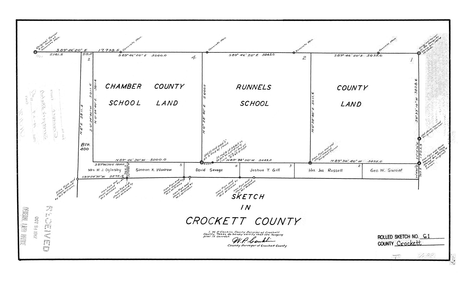
Crockett County Rolled Sketch 61
Sketch in Crockett County
-
Map/Doc
5604
-
Collection
General Map Collection
-
Object Dates
1947/10/29 (File Date)
-
People and Organizations
W.P. Conklin (Surveyor/Engineer)
-
Counties
Crockett
-
Subjects
Surveying Rolled Sketch
-
Height x Width
12.7 x 20.9 inches
32.3 x 53.1 cm
Part of: General Map Collection

Erath County Working Sketch 39

Print $20.00
- Digital $50.00
Erath County Working Sketch 39
1976
Size 26.9 x 28.0 inches
Map/Doc 69120
Maps of Gulf Intracoastal Waterway, Texas - Sabine River to the Rio Grande and connecting waterways including ship channels

Print $20.00
- Digital $50.00
Maps of Gulf Intracoastal Waterway, Texas - Sabine River to the Rio Grande and connecting waterways including ship channels
1966
Size 14.7 x 21.0 inches
Map/Doc 61992
Howard County Sketch File 8

Print $3.00
- Digital $50.00
Howard County Sketch File 8
Size 20.8 x 18.7 inches
Map/Doc 11796
Map of Fort Worth

Print $40.00
- Digital $50.00
Map of Fort Worth
1902
Size 61.3 x 34.8 inches
Map/Doc 93274
Kinney County Sketch File 31

Print $40.00
- Digital $50.00
Kinney County Sketch File 31
1934
Size 15.3 x 13.6 inches
Map/Doc 29176
Kimble County Working Sketch 80

Print $20.00
- Digital $50.00
Kimble County Working Sketch 80
1971
Size 32.3 x 24.3 inches
Map/Doc 70148
Flight Mission No. BRE-1P, Frame 27, Nueces County

Print $20.00
- Digital $50.00
Flight Mission No. BRE-1P, Frame 27, Nueces County
1956
Size 18.5 x 22.4 inches
Map/Doc 86622
Houston County Sketch File 5a

Print $5.00
- Digital $50.00
Houston County Sketch File 5a
Size 8.5 x 9.4 inches
Map/Doc 26758
Val Verde County Sketch File XXX6

Print $6.00
- Digital $50.00
Val Verde County Sketch File XXX6
Size 17.0 x 9.9 inches
Map/Doc 39102
Galveston County

Print $40.00
- Digital $50.00
Galveston County
1939
Size 45.0 x 56.5 inches
Map/Doc 95505
Texas Official Travel Map [Major Metropolitan Areas]
![96830, Texas Official Travel Map [Major Metropolitan Areas], General Map Collection](https://historictexasmaps.com/wmedia_w700/maps/96830.tif.jpg)
Texas Official Travel Map [Major Metropolitan Areas]
2008
Size 33.2 x 36.1 inches
Map/Doc 96830
You may also like
Fisher County Sketch File 9

Print $4.00
- Digital $50.00
Fisher County Sketch File 9
1893
Size 11.1 x 8.5 inches
Map/Doc 22575
Leon County Sketch File 32

Print $4.00
- Digital $50.00
Leon County Sketch File 32
1955
Size 14.2 x 8.7 inches
Map/Doc 29832
Cherokee County Working Sketch 15

Print $20.00
- Digital $50.00
Cherokee County Working Sketch 15
1957
Size 22.5 x 26.1 inches
Map/Doc 67970
Flight Mission No. BRA-9M, Frame 62, Jefferson County

Print $20.00
- Digital $50.00
Flight Mission No. BRA-9M, Frame 62, Jefferson County
1953
Size 18.7 x 22.3 inches
Map/Doc 85645
Archer County Working Sketch 21

Print $20.00
- Digital $50.00
Archer County Working Sketch 21
1976
Size 18.2 x 27.4 inches
Map/Doc 67162
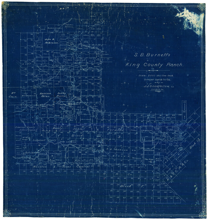
S.B. Burnett's King County Ranch
Print $20.00
- Digital $50.00
S.B. Burnett's King County Ranch
1902
Size 32.3 x 30.6 inches
Map/Doc 4441
[Surveys above the San Antonio Road]
![69758, [Surveys above the San Antonio Road], General Map Collection](https://historictexasmaps.com/wmedia_w700/maps/69758.tif.jpg)
Print $2.00
- Digital $50.00
[Surveys above the San Antonio Road]
1846
Size 8.5 x 7.6 inches
Map/Doc 69758
Concho County Sketch File 37

Print $20.00
- Digital $50.00
Concho County Sketch File 37
1938
Size 18.7 x 29.1 inches
Map/Doc 11162
Orange County Rolled Sketch 25

Print $20.00
- Digital $50.00
Orange County Rolled Sketch 25
1951
Size 29.0 x 43.5 inches
Map/Doc 10723
Pecos County Sketch File 87

Print $18.00
- Digital $50.00
Pecos County Sketch File 87
1916
Size 13.3 x 8.9 inches
Map/Doc 33975
Williamson County Sketch File 15

Print $4.00
- Digital $50.00
Williamson County Sketch File 15
Size 10.0 x 8.0 inches
Map/Doc 40334
Comment on Illustrations [SMS Ranch Booklet]
![96594, Comment on Illustrations [SMS Ranch Booklet], Cobb Digital Map Collection](https://historictexasmaps.com/wmedia_w700/pdf_converted_jpg/qi_pdf_thumbnail_40597.jpg)
Comment on Illustrations [SMS Ranch Booklet]
1916
Size 6.1 x 9.2 inches
Map/Doc 96594