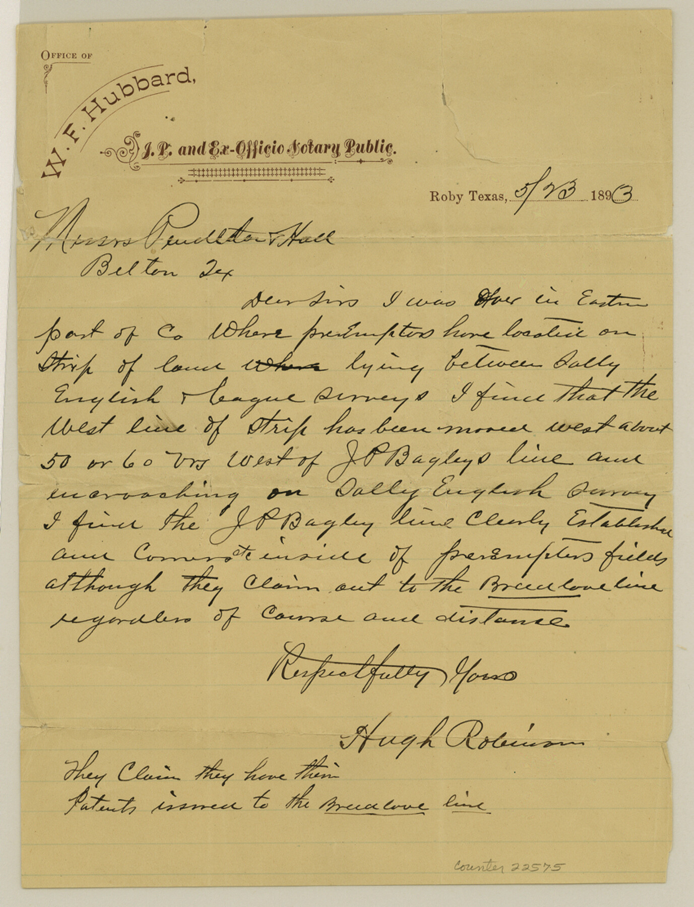
Fisher County Sketch File 9
[Letter regarding location of pre-emption surveys in eastern part of county]
-
Map/Doc
22575
-
Collection
General Map Collection
-
Object Dates
1893/5/23 (Creation Date)
-
People and Organizations
Hugh Robinson (Surveyor/Engineer)
J.P. Bagley (Surveyor/Engineer)
W.C. Breedlove (Surveyor/Engineer)
-
Counties
Fisher
-
Subjects
Surveying Sketch File
-
Height x Width
11.1 x 8.5 inches
28.2 x 21.6 cm
-
Medium
paper, manuscript
Part of: General Map Collection
Hutchinson County Sketch File 10

Print $40.00
- Digital $50.00
Hutchinson County Sketch File 10
Size 55.8 x 9.2 inches
Map/Doc 10500
Lampasas County Boundary File 16

Print $14.00
- Digital $50.00
Lampasas County Boundary File 16
Size 8.9 x 8.2 inches
Map/Doc 56216
Right of Way and Track Map, The Missouri, Kansas and Texas Ry. of Texas operated by the Missouri, Kansas and Texas Ry. of Texas, Henrietta Division

Print $40.00
- Digital $50.00
Right of Way and Track Map, The Missouri, Kansas and Texas Ry. of Texas operated by the Missouri, Kansas and Texas Ry. of Texas, Henrietta Division
1918
Size 25.5 x 57.0 inches
Map/Doc 64071
Edwards County Working Sketch 114

Print $20.00
- Digital $50.00
Edwards County Working Sketch 114
1972
Size 33.6 x 33.1 inches
Map/Doc 68990
Burnet County Working Sketch 16

Print $20.00
- Digital $50.00
Burnet County Working Sketch 16
1979
Size 22.8 x 32.5 inches
Map/Doc 67859
Concho, San Saba & Llano Valley Railway, Sterling City Branch, Texas. Right of Way and Track Map

Print $40.00
- Digital $50.00
Concho, San Saba & Llano Valley Railway, Sterling City Branch, Texas. Right of Way and Track Map
1910
Size 18.1 x 121.2 inches
Map/Doc 64438
Map of the Fort Worth & Denver City Railway, Wichita County, Texas

Print $40.00
- Digital $50.00
Map of the Fort Worth & Denver City Railway, Wichita County, Texas
1885
Size 23.7 x 66.5 inches
Map/Doc 64455

Hockley County Boundary File 1

Print $8.00
- Digital $50.00
Hockley County Boundary File 1
Size 13.5 x 8.5 inches
Map/Doc 54798
Lynn County Boundary File 14

Print $6.00
- Digital $50.00
Lynn County Boundary File 14
Size 8.9 x 14.2 inches
Map/Doc 56754
Midland County

Print $20.00
- Digital $50.00
Midland County
1930
Size 45.7 x 39.6 inches
Map/Doc 66930
Presidio County Rolled Sketch 139

Print $20.00
- Digital $50.00
Presidio County Rolled Sketch 139
2002
Size 24.5 x 27.5 inches
Map/Doc 78647
You may also like
Flight Mission No. BRA-8M, Frame 141, Jefferson County

Print $20.00
- Digital $50.00
Flight Mission No. BRA-8M, Frame 141, Jefferson County
1953
Size 18.8 x 22.4 inches
Map/Doc 85633
Reeves County Rolled Sketch 40

Print $20.00
- Digital $50.00
Reeves County Rolled Sketch 40
2019
Size 18.1 x 24.2 inches
Map/Doc 95826
San Patricio County Rolled Sketch 29

Print $20.00
- Digital $50.00
San Patricio County Rolled Sketch 29
Size 39.2 x 45.5 inches
Map/Doc 9893
Real County Working Sketch 55

Print $20.00
- Digital $50.00
Real County Working Sketch 55
1960
Size 21.6 x 35.1 inches
Map/Doc 71947
Map of Galveston, Turtle & East Bays & portion of the Gulf of Mexico in Chambers & Galveston Counties, Texas showing subdivision therof for mineral development

Print $20.00
- Digital $50.00
Map of Galveston, Turtle & East Bays & portion of the Gulf of Mexico in Chambers & Galveston Counties, Texas showing subdivision therof for mineral development
1935
Size 40.7 x 47.7 inches
Map/Doc 2939
Matagorda Bay Including Lavaca and Tres Palacios Bays

Print $40.00
- Digital $50.00
Matagorda Bay Including Lavaca and Tres Palacios Bays
1973
Size 37.0 x 48.4 inches
Map/Doc 73363
Fort Bend County Rolled Sketch B

Print $20.00
- Digital $50.00
Fort Bend County Rolled Sketch B
Size 20.4 x 28.9 inches
Map/Doc 5904
Right-of-Way and Track Map, Texas State Railroad operated by the T. and N.O. R.R. Co.

Print $40.00
- Digital $50.00
Right-of-Way and Track Map, Texas State Railroad operated by the T. and N.O. R.R. Co.
1917
Size 24.7 x 56.0 inches
Map/Doc 64172
Marion County Working Sketch 46

Print $20.00
- Digital $50.00
Marion County Working Sketch 46
2011
Size 21.4 x 29.1 inches
Map/Doc 90032
La Salle County Sketch File 40

Print $6.00
- Digital $50.00
La Salle County Sketch File 40
1918
Size 11.2 x 8.7 inches
Map/Doc 29594
Map showing Center Lines on Holley St.

Print $3.00
- Digital $50.00
Map showing Center Lines on Holley St.
1912
Size 6.1 x 17.5 inches
Map/Doc 495
Wichita County Sketch File 17

Print $20.00
- Digital $50.00
Wichita County Sketch File 17
1889
Size 29.7 x 22.4 inches
Map/Doc 12680