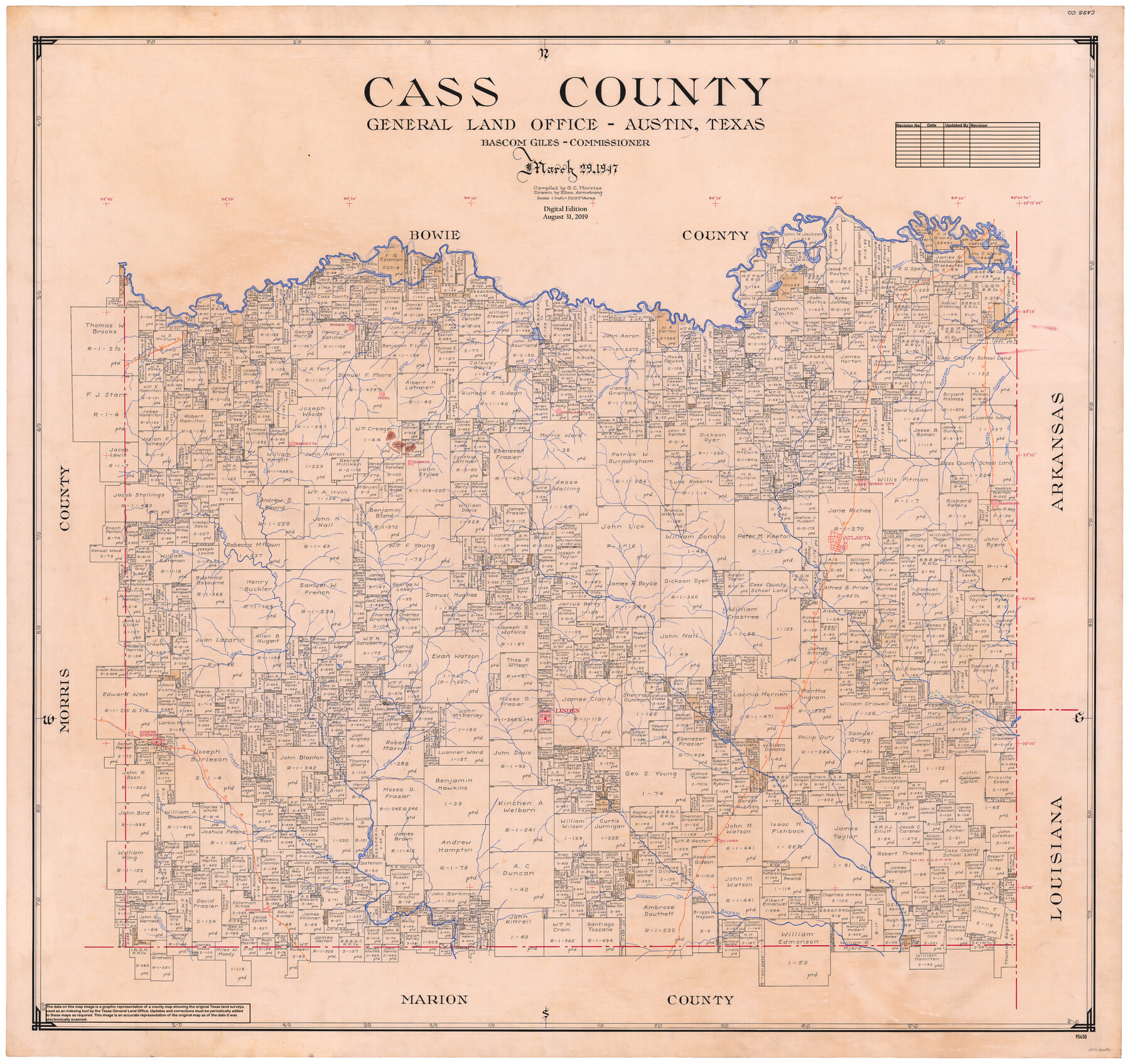
Cass County
General Land Office Official County Map
-
Map/Doc
95450
-
Collection
General Map Collection
-
Object Dates
2019/8/31 (Revision Date)
1947/3/29 (Creation Date)
-
People and Organizations
Cheyenne Betancourt (Draftsman)
Eltea Armstrong (Draftsman)
G.C. Morriss (Compiler)
Bascom Giles (GLO Commissioner)
-
Counties
Cass
-
Subjects
County OCM
-
Height x Width
40.7 x 43.2 inches
103.4 x 109.7 cm
-
Medium
digital image
-
Scale
1" = 2000 varas
Part of: General Map Collection
Copy of Surveyor's Field Book, Morris Browning - In Blocks 7, 5 & 4, I&GNRRCo., Hutchinson and Carson Counties, Texas

Print $2.00
- Digital $50.00
Copy of Surveyor's Field Book, Morris Browning - In Blocks 7, 5 & 4, I&GNRRCo., Hutchinson and Carson Counties, Texas
1888
Size 7.0 x 8.8 inches
Map/Doc 62278
Freestone County Working Sketch 15

Print $40.00
- Digital $50.00
Freestone County Working Sketch 15
1980
Size 56.5 x 33.7 inches
Map/Doc 69257
Howard County Rolled Sketch 12A

Print $20.00
- Digital $50.00
Howard County Rolled Sketch 12A
1948
Size 23.3 x 13.9 inches
Map/Doc 6244
Fort Bend County State Real Property Sketch 13

Print $40.00
- Digital $50.00
Fort Bend County State Real Property Sketch 13
1987
Size 36.3 x 47.9 inches
Map/Doc 61687

Montague County Working Sketch 41

Print $40.00
- Digital $50.00
Montague County Working Sketch 41
1923
Size 43.3 x 70.1 inches
Map/Doc 65350
Swisher County Rolled Sketch 3

Print $20.00
- Digital $50.00
Swisher County Rolled Sketch 3
Size 21.3 x 19.4 inches
Map/Doc 7904
Calhoun County Sketch File 3

Print $4.00
- Digital $50.00
Calhoun County Sketch File 3
Size 8.0 x 12.0 inches
Map/Doc 35899
Flight Mission No. DAG-18K, Frame 73, Matagorda County

Print $20.00
- Digital $50.00
Flight Mission No. DAG-18K, Frame 73, Matagorda County
1952
Size 18.5 x 22.2 inches
Map/Doc 86366
La Salle County Sketch File 10

Print $4.00
- Digital $50.00
La Salle County Sketch File 10
1877
Size 9.0 x 7.0 inches
Map/Doc 42997
Jasper County Working Sketch 8

Print $20.00
- Digital $50.00
Jasper County Working Sketch 8
1915
Size 20.1 x 31.4 inches
Map/Doc 66470
Harbor of Brazos Santiago, Texas

Print $20.00
- Digital $50.00
Harbor of Brazos Santiago, Texas
1887
Size 27.1 x 18.3 inches
Map/Doc 72995
You may also like
Map of Palo Pinto County Texas

Print $20.00
- Digital $50.00
Map of Palo Pinto County Texas
1879
Size 22.0 x 17.3 inches
Map/Doc 3933
[Val Verde County]
![63095, [Val Verde County], General Map Collection](https://historictexasmaps.com/wmedia_w700/maps/63095.tif.jpg)
Print $20.00
- Digital $50.00
[Val Verde County]
1898
Size 39.1 x 32.4 inches
Map/Doc 63095
Stonewall County Boundary File 4

Print $32.00
- Digital $50.00
Stonewall County Boundary File 4
Size 14.4 x 9.1 inches
Map/Doc 58977
Jefferson County Sketch File 15a

Print $8.00
- Digital $50.00
Jefferson County Sketch File 15a
1872
Size 15.6 x 6.7 inches
Map/Doc 28156
Flight Mission No. BRE-2P, Frame 62, Nueces County

Print $20.00
- Digital $50.00
Flight Mission No. BRE-2P, Frame 62, Nueces County
1956
Size 18.3 x 22.5 inches
Map/Doc 86757
Schleicher County Sketch File 27

Print $20.00
- Digital $50.00
Schleicher County Sketch File 27
Size 23.0 x 19.2 inches
Map/Doc 12305
Revised map of the State of Texas

Print $20.00
- Digital $50.00
Revised map of the State of Texas
1876
Size 19.6 x 19.7 inches
Map/Doc 95755
Hudspeth County Sketch File 17

Print $11.00
- Digital $50.00
Hudspeth County Sketch File 17
1929
Size 9.3 x 14.6 inches
Map/Doc 26954
Aransas County Rolled Sketch 3

Print $20.00
- Digital $50.00
Aransas County Rolled Sketch 3
Size 20.9 x 26.5 inches
Map/Doc 77188
Kleberg County Rolled Sketch 10-33

Print $20.00
- Digital $50.00
Kleberg County Rolled Sketch 10-33
1950
Size 36.5 x 32.1 inches
Map/Doc 9393
Crane County Working Sketch 11

Print $20.00
- Digital $50.00
Crane County Working Sketch 11
1941
Size 18.8 x 18.4 inches
Map/Doc 68288
Brooks County Rolled Sketch 7

Print $20.00
- Digital $50.00
Brooks County Rolled Sketch 7
1916
Size 28.5 x 30.4 inches
Map/Doc 5336