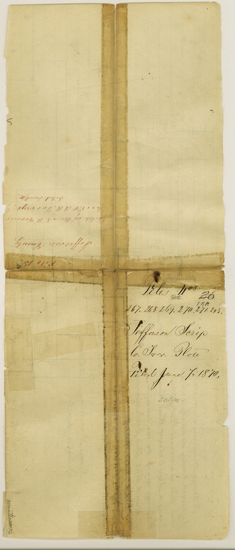
Jefferson County Sketch File 15a
[Sketch around Pine Island Bayou in the northwest part of the county]
-
Map/Doc
28156
-
Collection
General Map Collection
-
Object Dates
3/22/1872 (Creation Date)
3/22/1872 (File Date)
6/7/1870 (File Date)
-
People and Organizations
Stakemann (Surveyor/Engineer)
George Armstrong (Surveyor/Engineer)
-
Counties
Jefferson Hardin Liberty
-
Subjects
Surveying Sketch File
-
Height x Width
15.6 x 6.7 inches
39.6 x 17.0 cm
-
Medium
paper, manuscript
-
Features
Pine Island Bayou
Cotton Creek
Mellon Marsh Bayou
Part of: General Map Collection
[Del Rio, Texas]
![2070, [Del Rio, Texas], General Map Collection](https://historictexasmaps.com/wmedia_w700/maps/2070-1.tif.jpg)
Print $20.00
- Digital $50.00
[Del Rio, Texas]
1886
Size 24.2 x 34.3 inches
Map/Doc 2070
Panola County Working Sketch 36

Print $40.00
- Digital $50.00
Panola County Working Sketch 36
1984
Map/Doc 71445
Ward County Working Sketch 37

Print $20.00
- Digital $50.00
Ward County Working Sketch 37
1969
Size 31.3 x 46.9 inches
Map/Doc 72343
Public Land on Mustang Island, Nueces County

Print $20.00
- Digital $50.00
Public Land on Mustang Island, Nueces County
1910
Size 17.0 x 17.5 inches
Map/Doc 93362
Flight Mission No. BRA-16M, Frame 74, Jefferson County

Print $20.00
- Digital $50.00
Flight Mission No. BRA-16M, Frame 74, Jefferson County
1953
Size 18.6 x 22.5 inches
Map/Doc 85691
Jasper County Working Sketch 8

Print $20.00
- Digital $50.00
Jasper County Working Sketch 8
1915
Size 20.1 x 31.4 inches
Map/Doc 66470
Willacy County

Print $20.00
- Digital $50.00
Willacy County
1921
Size 25.2 x 32.2 inches
Map/Doc 73325
Anderson County Sketch File 1

Print $4.00
- Digital $50.00
Anderson County Sketch File 1
1845
Size 12.5 x 8.3 inches
Map/Doc 12737
Concho County Boundary File 4

Print $2.00
- Digital $50.00
Concho County Boundary File 4
Size 12.7 x 8.4 inches
Map/Doc 51825
Jefferson County Rolled Sketch 3

Print $20.00
- Digital $50.00
Jefferson County Rolled Sketch 3
1909
Size 36.0 x 16.2 inches
Map/Doc 6384
Jim Wells County Boundary File 2

Print $4.00
- Digital $50.00
Jim Wells County Boundary File 2
Size 8.7 x 11.3 inches
Map/Doc 55544
Terrell County Working Sketch 82

Print $20.00
- Digital $50.00
Terrell County Working Sketch 82
1991
Size 31.7 x 24.8 inches
Map/Doc 69603
You may also like
Guadalupe County Sketch File 8

Print $7.00
- Digital $50.00
Guadalupe County Sketch File 8
1871
Size 10.4 x 8.3 inches
Map/Doc 24674
Concho County Rolled Sketch 26

Print $20.00
- Digital $50.00
Concho County Rolled Sketch 26
1979
Size 15.1 x 18.1 inches
Map/Doc 5558
[Sketch for Mineral Application 17237 / Mineral File 11855 - Neches River, Joe A. Sanders]
![2819, [Sketch for Mineral Application 17237 / Mineral File 11855 - Neches River, Joe A. Sanders], General Map Collection](https://historictexasmaps.com/wmedia_w700/maps/2819.tif.jpg)
Print $2.00
- Digital $50.00
[Sketch for Mineral Application 17237 / Mineral File 11855 - Neches River, Joe A. Sanders]
1927
Size 12.8 x 8.2 inches
Map/Doc 2819
Stonewall County Rolled Sketch 34

Print $20.00
- Digital $50.00
Stonewall County Rolled Sketch 34
Size 37.5 x 30.2 inches
Map/Doc 7878
[SW Corner of Yoakum County]
![92443, [SW Corner of Yoakum County], Twichell Survey Records](https://historictexasmaps.com/wmedia_w700/maps/92443-1.tif.jpg)
Print $20.00
- Digital $50.00
[SW Corner of Yoakum County]
Size 24.2 x 18.5 inches
Map/Doc 92443
United States Bathymetric and Fishing Maps including Topographic/Bathymetric Maps

Print $40.00
- Digital $50.00
United States Bathymetric and Fishing Maps including Topographic/Bathymetric Maps
1992
Size 21.5 x 54.9 inches
Map/Doc 76128
Llano County Sketch File 17

Print $20.00
- Digital $50.00
Llano County Sketch File 17
1949
Size 21.8 x 20.2 inches
Map/Doc 12012
Shelby County Working Sketch 11

Print $20.00
- Digital $50.00
Shelby County Working Sketch 11
1945
Size 32.2 x 43.2 inches
Map/Doc 63864
Atascosa County Sketch File 8a

Print $4.00
- Digital $50.00
Atascosa County Sketch File 8a
Size 13.9 x 8.4 inches
Map/Doc 13761
Fayette County Working Sketch Graphic Index

Print $40.00
- Digital $50.00
Fayette County Working Sketch Graphic Index
1978
Size 42.9 x 54.7 inches
Map/Doc 76541
Reagan County Working Sketch 31

Print $20.00
- Digital $50.00
Reagan County Working Sketch 31
1964
Size 38.7 x 36.6 inches
Map/Doc 71873
Uvalde County Working Sketch 15

Print $20.00
- Digital $50.00
Uvalde County Working Sketch 15
1945
Size 18.5 x 26.9 inches
Map/Doc 72085