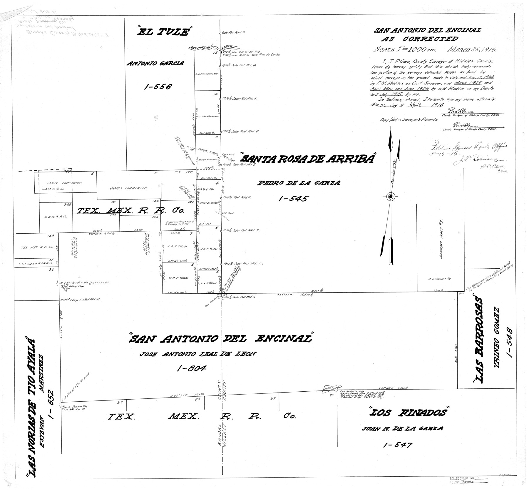
Brooks County Rolled Sketch 7
San Antonio del Encinal as corrected
-
Map/Doc
5336
-
Collection
General Map Collection
-
Object Dates
1916/3/25 (Creation Date)
1916/5/12 (File Date)
-
People and Organizations
T.P. Gore (Surveyor/Engineer)
-
Counties
Brooks Willacy
-
Subjects
Surveying Rolled Sketch
-
Height x Width
28.5 x 30.4 inches
72.4 x 77.2 cm
-
Scale
1" = 1000 varas
Part of: General Map Collection
Flight Mission No. CRK-5P, Frame 157, Refugio County

Print $20.00
- Digital $50.00
Flight Mission No. CRK-5P, Frame 157, Refugio County
1956
Size 18.8 x 22.6 inches
Map/Doc 86938
Map of Travis County

Print $20.00
- Digital $50.00
Map of Travis County
1861
Size 24.0 x 28.6 inches
Map/Doc 4088
Loving County Working Sketch 21

Print $20.00
- Digital $50.00
Loving County Working Sketch 21
1984
Size 26.7 x 36.0 inches
Map/Doc 70655
Crane County Sketch File 19

Print $4.00
- Digital $50.00
Crane County Sketch File 19
1927
Size 11.4 x 8.8 inches
Map/Doc 19584
Sterling County Rolled Sketch 25

Print $20.00
- Digital $50.00
Sterling County Rolled Sketch 25
Size 31.4 x 35.3 inches
Map/Doc 9955
Navigation Maps of Gulf Intracoastal Waterway, Port Arthur to Brownsville, Texas

Print $4.00
- Digital $50.00
Navigation Maps of Gulf Intracoastal Waterway, Port Arthur to Brownsville, Texas
1951
Size 16.7 x 21.5 inches
Map/Doc 65442
Flight Mission No. BQY-4M, Frame 44, Harris County

Print $20.00
- Digital $50.00
Flight Mission No. BQY-4M, Frame 44, Harris County
1953
Size 18.5 x 22.4 inches
Map/Doc 85259
McLennan County Sketch File 3

Print $4.00
- Digital $50.00
McLennan County Sketch File 3
1857
Size 11.1 x 8.1 inches
Map/Doc 31233
Navarro County Sketch File 3

Print $8.00
- Digital $50.00
Navarro County Sketch File 3
1847
Size 10.2 x 8.1 inches
Map/Doc 32300
Colorado County Boundary File 1

Print $8.00
- Digital $50.00
Colorado County Boundary File 1
Size 14.0 x 8.6 inches
Map/Doc 51768
Flight Mission No. CRE-3R, Frame 39, Jackson County

Print $20.00
- Digital $50.00
Flight Mission No. CRE-3R, Frame 39, Jackson County
1956
Size 18.6 x 22.2 inches
Map/Doc 85386
Gregg County Boundary File 4

Print $14.00
- Digital $50.00
Gregg County Boundary File 4
Size 14.1 x 8.6 inches
Map/Doc 53992
You may also like
Palo Pinto County

Print $40.00
- Digital $50.00
Palo Pinto County
1941
Size 48.3 x 39.4 inches
Map/Doc 66966
![[San Benito Promotional Booklet]](https://historictexasmaps.com/wmedia_w700/pdf_converted_jpg/qi_pdf_thumbnail_64211.jpg)
Van Zandt County Rolled Sketch 11

Print $20.00
- Digital $50.00
Van Zandt County Rolled Sketch 11
2019
Size 23.6 x 36.0 inches
Map/Doc 95717
Webb County Sketch File 9-2

Print $4.00
- Digital $50.00
Webb County Sketch File 9-2
1916
Size 11.3 x 8.6 inches
Map/Doc 39764
[Block B5, Capitol Leagues 217, 218, and 239]
![91438, [Block B5, Capitol Leagues 217, 218, and 239], Twichell Survey Records](https://historictexasmaps.com/wmedia_w700/maps/91438-1.tif.jpg)
Print $3.00
- Digital $50.00
[Block B5, Capitol Leagues 217, 218, and 239]
Size 15.1 x 10.0 inches
Map/Doc 91438
Dimmit County Working Sketch 15

Print $20.00
- Digital $50.00
Dimmit County Working Sketch 15
1942
Size 19.0 x 34.5 inches
Map/Doc 68676
Edwards County Working Sketch 112

Print $20.00
- Digital $50.00
Edwards County Working Sketch 112
1972
Size 20.0 x 26.4 inches
Map/Doc 68988
Collin County Working Sketch 6

Print $20.00
- Digital $50.00
Collin County Working Sketch 6
1996
Size 11.2 x 42.2 inches
Map/Doc 68100
[Panhandle Counties]
![92067, [Panhandle Counties], Twichell Survey Records](https://historictexasmaps.com/wmedia_w700/maps/92067-1.tif.jpg)
Print $2.00
- Digital $50.00
[Panhandle Counties]
Size 12.3 x 9.1 inches
Map/Doc 92067
Morris County Rolled Sketch 2A

Print $20.00
- Digital $50.00
Morris County Rolled Sketch 2A
Size 24.0 x 18.8 inches
Map/Doc 10257
Map of Fannin County

Print $40.00
- Digital $50.00
Map of Fannin County
1841
Size 50.4 x 46.8 inches
Map/Doc 7821
Flight Mission No. CRC-3R, Frame 97, Chambers County

Print $20.00
- Digital $50.00
Flight Mission No. CRC-3R, Frame 97, Chambers County
1956
Size 18.5 x 22.3 inches
Map/Doc 84835